102.67.179.59 - IP Lookup: Free IP Address Lookup, Postal Code Lookup, IP Location Lookup, IP ASN, Public IP
Country:
Region:
City:
Location:
Time Zone:
Postal Code:
ISP:
ASN:
language:
User-Agent:
Proxy IP:
Blacklist:
IP information under different IP Channel
ip-api
Country
Region
City
ASN
Time Zone
ISP
Blacklist
Proxy
Latitude
Longitude
Postal
Route
db-ip
Country
Region
City
ASN
Time Zone
ISP
Blacklist
Proxy
Latitude
Longitude
Postal
Route
IPinfo
Country
Region
City
ASN
Time Zone
ISP
Blacklist
Proxy
Latitude
Longitude
Postal
Route
IP2Location
102.67.179.59Country
Region
kwazulu-natal
City
durban
Time Zone
Africa/Johannesburg
ISP
Language
User-Agent
Latitude
Longitude
Postal
ipdata
Country
Region
City
ASN
Time Zone
ISP
Blacklist
Proxy
Latitude
Longitude
Postal
Route
Popular places and events near this IP address
Kingsmead Cricket Ground
Cricket ground
Distance: Approx. 845 meters
Latitude and longitude: -29.85,31.02777778
Kingsmead is a cricket ground in Durban, KwaZulu-Natal, South Africa. Its stated capacity is 25,000, although grass terracing makes up part of the viewing area. The 'end names' are the Umgeni End (north) and the Old Fort Road End (south).

Inkosi Albert Luthuli International Convention Centre
Convention centre in Durban, South Africa
Distance: Approx. 442 meters
Latitude and longitude: -29.85361111,31.03
The Inkosi Albert Luthuli International Convention Centre Complex, often abbreviated as ICC Durban, is a large events facility located in the city centre of Durban, KwaZulu-Natal, South Africa. It is named after 1960 Nobel Peace Prize laureate and former president of the African National Congress, Inkosi Albert Luthuli. Opened by former president Nelson Mandela in 1997, the Durban ICC was South Africa’s first International Convention Centre and has played a pioneering role in attracting international events to Durban since its inception.
Battle of Congella
Distance: Approx. 768 meters
Latitude and longitude: -29.85111111,31.02611111
The Battle of Congella, beginning 23 May 1842, was between the British of the Cape colony and Voortrekkers or the Boer forces of the Natalia Republic. The Republic of Natalia sought an independent port of entry, free from British control and thus sought to conquer the Port Natal trading settlement which had been settled by mostly British merchants in modern-day KwaZulu-Natal. The battle ended in a British victory due to the heroic ride of Dick King for reinforcements.

The Cenotaph, Durban
World War I memorial in South Africa
Distance: Approx. 398 meters
Latitude and longitude: -29.85870278,31.02521667
The Cenotaph was erected in Farewell Square, Durban, South Africa, as a war memorial to soldiers who died in World War I. Standing about 11 metres (36 feet) high, the Cenotaph is built out of granite decorated with glazed ceramic tiles depicting two angels raising the soul of a dead soldier. The vivid color of the figurative decoration makes the Cenotaph possibly unique among World War I memorials of its kind. The design was the result of a competition in 1921, won by the Cape Town architectural firm of Eagle, Pilkington, and McQueen.

John Ross House (Durban, South Africa)
Skyscraper
Distance: Approx. 382 meters
Latitude and longitude: -29.86082,31.03011
The John Ross House in Durban, South Africa is a 33-storey skyscraper on Victoria Embankment. It is named after "John Ross" (real name, Charles Rawden Maclean), who at the age of 15 walked from Port Natal to Delagoa Bay and back to procure medicine and supplies. His statue stands outside the building.

Trams in Durban
Former public transport system in Durban, South Africa
Distance: Approx. 675 meters
Latitude and longitude: -29.85861111,31.02222222
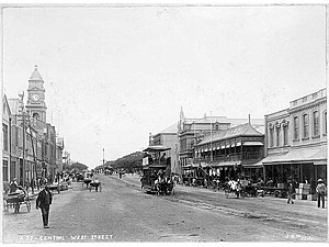
The Durban tramway network formed part of the public transport system in Durban, South Africa, for nearly 70 years until the end of the 1940s.
88 on Field
Skyscraper in Durban, KwaZulu-Natal, South Africa
Distance: Approx. 678 meters
Latitude and longitude: -29.858,31.0221
88 on Field is a skyscraper in Durban, KwaZulu-Natal, South Africa. It was built in 1985, has 25 floors and is 147 meters (482 feet) tall.
Durban Club
Club in Durban, South Africa
Distance: Approx. 611 meters
Latitude and longitude: -29.86109,31.02431
In May 1854 Durban had a population of 1,204 settlers which meant that it qualified to be elevated to the status of a Borough. On 14 June 1854, 20 prominent Durban residents signed an agreement to form the first D'Urban Club, named after Sir Benjamin D'Urban, Governor of the Cape Colony. The newly formed club was to be used for the playing of billiards, chess and as a reading and newsroom.
Point Waterfront
Place in KwaZulu-Natal, South Africa
Distance: Approx. 777 meters
Latitude and longitude: -29.8611,31.036
Point Waterfront is a harbour-side town located at the entrance to the Port of Durban. During the last 50 years the town suffered decay and was left mostly abandoned. The uShaka Marine World is located here.
Quadrant House (Durban)
Building in Durban, South Africa
Distance: Approx. 750 meters
Latitude and longitude: -29.86134722,31.022725
The Quadrant House is a Grade II listed building situated in Durban, South Africa.

Durban City Hall
Building in Durban, South Africa
Distance: Approx. 275 meters
Latitude and longitude: -29.8585,31.0265
Durban City Hall is a historic city hall located at Durban in KwaZulu-Natal, South Africa.

St. Paul's Anglican Church, Durban
South African church
Distance: Approx. 324 meters
Latitude and longitude: -29.85726,31.02576
St. Paul's Anglican Church is an Anglican church in Durban, KwaZulu-Natal, South Africa. The original St.
Weather in this IP's area
clear sky
24 Celsius
25 Celsius
24 Celsius
24 Celsius
1009 hPa
95 %
1009 hPa
1008 hPa
10000 meters
3.53 m/s
6 m/s
30 degree
1 %

