102.49.205.150 - IP Lookup: Free IP Address Lookup, Postal Code Lookup, IP Location Lookup, IP ASN, Public IP
Country:
Region:
City:
Location:
Time Zone:
Postal Code:
IP information under different IP Channel
ip-api
Country
Region
City
ASN
Time Zone
ISP
Blacklist
Proxy
Latitude
Longitude
Postal
Route
Luminati
Country
Region
04
City
temara
ASN
Time Zone
Africa/Casablanca
ISP
Itissalat Al-MAGHRIB
Latitude
Longitude
Postal
IPinfo
Country
Region
City
ASN
Time Zone
ISP
Blacklist
Proxy
Latitude
Longitude
Postal
Route
IP2Location
102.49.205.150Country
Region
tanger-tetouan-al hoceima
City
boukhalef
Time Zone
Africa/Casablanca
ISP
Language
User-Agent
Latitude
Longitude
Postal
db-ip
Country
Region
City
ASN
Time Zone
ISP
Blacklist
Proxy
Latitude
Longitude
Postal
Route
ipdata
Country
Region
City
ASN
Time Zone
ISP
Blacklist
Proxy
Latitude
Longitude
Postal
Route
Popular places and events near this IP address

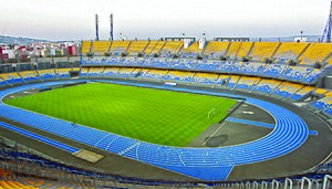
Ibn Batouta Stadium
Multiuse stadium in Tangier, Morocco
Distance: Approx. 3856 meters
Latitude and longitude: 35.741211,-5.858105
The Ibn Batouta Stadium or Grand stade of Tangier (Arabic: ملعب ابن بطوطة; Berber languages: ⴰⵏⵏⴰⵔ ⵏ ⵉⴱⵏ ⴱⴰⵜⵓⵜⴰ) is a multi-use stadium in Tangier, Morocco. It is used mostly for football matches and big events such as ceremonies or concerts. The stadium now has a legal capacity of 65,000 after renovation construction finished for hosting the 2022 FIFA Club World Cup.
Tangier Exportation Free Zone
Distance: Approx. 2099 meters
Latitude and longitude: 35.7184,-5.9145
Tangier Exportation Free Zone is a free economic zone located south of Tangier, Morocco. The zone has an area of 3.45 km2. It is managed by Tangier Free Zone (TFZ).
Tangier Anglo-Moroccan School
Private school in Tangier, Morocco
Distance: Approx. 2493 meters
Latitude and longitude: 35.737575,-5.87254167
Construction of the Anglo-Moroccan School (AMS) in Tangier, Morocco was completed in August 2008. The AMS project created by Russell Edwards was started in 2005 with substantial assistance from the Moroccan authorities. The aim was to create a modern international style school that would help Tangier by providing education for the growing number of children of foreign nationals and Moroccan expatriates living in Tangier.

Grand Mosque of Tangier
Mosque in Tangier, Morocco
Distance: Approx. 7794 meters
Latitude and longitude: 35.76615,-5.82365
The Grand Mosque of Tangier (Arabic: مسجد طنجة الكبير) is the historic main mosque (Friday mosque) of Tangier, Morocco, located in the city's old medina. While the design of the current mosque dates from the early 19th century during the Alaouite period, the site has been occupied by a succession of religious buildings since antiquity.
National Cricket Stadium, Tangier
Distance: Approx. 5855 meters
Latitude and longitude: 35.77166667,-5.85583333
The National Cricket Stadium was a cricket ground located in Tangiers, Morocco. It was the only stadium in Morocco that had been used for senior cricket. The stadium hosted its first international tournament from 12 to 21 August 2002.
École nationale des sciences appliquées de Tanger
Distance: Approx. 599 meters
Latitude and longitude: 35.73694444,-5.89527778
The École nationale des sciences appliquées de Tanger(ENSAT) located in Tangier the capital of the northern region of Morocco, is a Moroccan engineering school created through a partnership between the University Abdelmalek Essaâdi and INSA de Lyon. It is a public establishment, training state engineers with general specializations in :Cybersecurity and CyberIntelligence, telecommunication systems & networks, Computer Engineering, Electronic Systems Engineering and Control, and Industrial Engineering & logistics.
Caves of Hercules
Moroccan cultural heritage site
Distance: Approx. 4712 meters
Latitude and longitude: 35.76027778,-5.93916667
The Caves of Hercules is an archaeological cave complex located in Cape Spartel, Morocco.
Cape Spartel
Promontory on the northwestern tip of Morocco
Distance: Approx. 7566 meters
Latitude and longitude: 35.80055556,-5.90611111
Cape Spartel (Arabic: رأس سبارطيل; French: Cap Spartel; Spanish: Cabo Espartel) is a promontory in Morocco about 1,000 feet (300 m) above sea level at the entrance to the Strait of Gibraltar, 12 km west of Tangier. It is the northwesternmost point of the African continent. Below the cape are the Caves of Hercules.
American School of Tangier
Distance: Approx. 8276 meters
Latitude and longitude: 35.775121,-5.824187
American School of Tangier (AST; Arabic: المدرسة الأمریکیة بطنجة) is an American international school in Tangier, Morocco, serving preschool through grade 12. In Morocco it is considered a non-profit organization, and AST is incorporated in the U.S. state of Delaware as a 501(c)(3) nonprofit. AST is accredited by the Middle States Association of Colleges and Schools.

Bni Makada
Distance: Approx. 7571 meters
Latitude and longitude: 35.7511,-5.8188
Bni Makada is one of the four arrondissements or districts of the city of Ṭanja, Morocco. Administratively it is part of the prefecture of Ṭanja-Aẓila in the region of Ṭanja-Tiṭwan-Elḥusima. The 2014 Moroccan census recorded a population of 386,191 people living in 91,737 households.

Lycée Moulay Rachid
Senior high school in Tangier, Morocco
Distance: Approx. 8658 meters
Latitude and longitude: 35.783,-5.8263
Lycée Moulay Rachid ("Moulay Rachid High School"; Arabic: الثانوية التأهيلية مولاي رشيد; Kabyle: ⵜⴰⵙⵔⴰⵔⵜ ⵏ ⵎⵓⵍⴰⵢ? ⵔⴰⵛⵞⴷ) is a coeducational senior high school/sixth-form college in the Al Ouchak area of Tangier, Morocco, named after Prince Moulay Rachid. It was first established in 1975 as the Collège 3ème arrondissement.

Perdicaris Park
Public park in Tangier, Morocco
Distance: Approx. 6323 meters
Latitude and longitude: 35.788,-5.883
The Perdicaris Park, also known as the Rmilat Forest and formerly as Villa Aidonia or Place of the Nightingales, is a public park covering 70 hectares in the Rmilat neighborhood of Tangier, Morocco. It is located on the northern slopes of the Jebel Kebir hill facing the Strait of Gibraltar, between the Cape Spartel reserve to its west and the Jebel Kebir Royal Palace to its east. It is named after Greek-American notable Ion Hanford Perdicaris, who created it in the 1870s and was kidnapped there in the mid-1904 Perdicaris Incident.
Weather in this IP's area
clear sky
13 Celsius
12 Celsius
13 Celsius
13 Celsius
1024 hPa
71 %
1024 hPa
1021 hPa
10000 meters
5.66 m/s
80 degree

