Country:
 Egypt
EgyptRegion:
City:
Latitude and Longitude:
Time Zone:
Postal Code:
IP information under different IP Channel
ip-api
Country
Region
City
ASN
Time Zone
ISP
Blacklist
Proxy
Latitude
Longitude
Postal
Route
IPinfo
Country
Region
City
ASN
Time Zone
ISP
Blacklist
Proxy
Latitude
Longitude
Postal
Route
MaxMind
Country
Region
City
ASN
Time Zone
ISP
Blacklist
Proxy
Latitude
Longitude
Postal
Route
Luminati
Country
EGRegion
c
City
cairo
ASN
Time Zone
Africa/Cairo
ISP
TE Data
Latitude
Longitude
Postal
db-ip
Country
Region
City
ASN
Time Zone
ISP
Blacklist
Proxy
Latitude
Longitude
Postal
Route
ipdata
Country
Region
City
ASN
Time Zone
ISP
Blacklist
Proxy
Latitude
Longitude
Postal
Route
Popular places and events near this IP address

Cairo Marriott Hotel
Building in Egypt
Distance: Approx. 288 meters
Latitude and longitude: 30.05694444,31.22472222
The Cairo Marriott Hotel is a large hotel located in the Zamalek district of Gezira Island in Egypt and is just west of Downtown Cairo. It is one of the tallest buildings in Cairo. The Marriott opened in 1982, but its central wing was built as the Gezirah Palace for the Khedive Isma'il Pasha in 1869 and converted to a luxury hotel in 1894.
Boulaq
District in Cairo, Egypt
Distance: Approx. 715 meters
Latitude and longitude: 30.053,31.23
Boulaq (Arabic: بولاق, romanized: Būlāq from Ancient Greek: φυλακή "guard, customs post"), is a district of Cairo, in Egypt. It neighbours Downtown Cairo, Azbakeya, and the River Nile.

Gezirah Palace
Palace in Cairo, Egypt
Distance: Approx. 247 meters
Latitude and longitude: 30.05722222,31.225
The Gezirah Palace (Arabic: قصر الجزيرة) was one of the Egyptian royal palaces of the Muhammad Ali Dynasty. It is located in the Zamalek district on Gezira Island in the Nile, just west of Downtown Cairo.
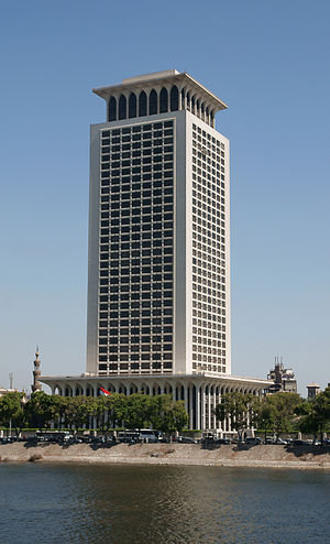
Ministry of Foreign Affairs (Egypt)
Egyptian government ministry
Distance: Approx. 523 meters
Latitude and longitude: 30.055,31.23
The Ministry of Foreign Affairs of the Arab Republic of Egypt (Arabic: وزارة الخارجية المصرية) is the Egyptian government ministry which oversees the foreign relations of Egypt. On 3 July 2024 Badr Abdelatty was appointed Minister of Foreign Affairs.

Tomb of Salar and Sangar al-Gawli
Distance: Approx. 218 meters
Latitude and longitude: 30.05805556,31.22888889
The Tomb of Salar and Sangar al-Gawli is a historic funerary and religious complex located in Cairo, Egypt, on the plateau of Qal'at al-Kabsh. It contains the mausoleums of Sayf al-Din Salar and A'lam al-Din Sanjar al-Jawli, who were Mamluk emirs of the 14th century. Currently, the complex is abandoned.

Cairo fire
1952 anti-British riots in downtown Cairo, Egypt
Distance: Approx. 218 meters
Latitude and longitude: 30.05805556,31.22888889
The Cairo fire (Arabic: حريق القاهرة), also known as Black Saturday, was a series of riots that took place on 26 January 1952, marked by the burning and looting of some 750 buildings—retail shops, cafes, cinemas, hotels, restaurants, theatres, nightclubs, and the city's Casino Opera —in downtown Cairo. The direct trigger of the riots was the Battle of Ismailia, an attack on an Egyptian police installation in Ismaïlia by British forces on 25 January, in which roughly 50 auxiliary policemen were killed. The spontaneous anti-British protests that followed these deaths were quickly seized upon by organized elements in the crowd, who burned and ransacked large sectors of Cairo amidst the unexplained absence of security forces.

All Saints' Cathedral, Cairo
Anglican cathedral in Egypt
Distance: Approx. 312 meters
Latitude and longitude: 30.058,31.2237
All Saints' Cathedral, Cairo was consecrated in 1988 and is the home of the Episcopal/Anglican Diocese of Egypt with North Africa and the Horn of Africa. The cathedral is located close to the Marriott Hotel in Zamalek, a residential area of the city that sits on an island in the middle of the River Nile. The building and land were donated by King Farouk.
Timeline of Cairo
Distance: Approx. 218 meters
Latitude and longitude: 30.05805556,31.22888889
The following is a timeline of the history of the city of Cairo, Egypt.
Prince Amr Ibrahim Palace
Historic building in Egypt and museum (established 1921)
Distance: Approx. 415 meters
Latitude and longitude: 30.0552,31.2257
The Prince Amr Ibrahim Palace is a historical building in Cairo's Zamalek island, which is used as the Egypt's first ceramics museum, the Museum of Islamic Ceramics and as an art center.

Sulayman Pasha Mosque
1528 mosque in Cairo, Egypt
Distance: Approx. 218 meters
Latitude and longitude: 30.05805556,31.22888889
Sulayman Pasha al-Khadem Mosque (Arabic: مسجد سليمان باشا الخادم), also known as Sariat al-Jabal Mosque, is a historical mosque established in 1528 by Suleiman Pasha Al-Khadem, one of the Ottoman rulers of Egypt. It is located inside the Cairo Citadel at the top of Mount Mokattam, and originally erected for the use of the janissaries stationed in the northern enclosure. It is the first mosque established in Egypt in Ottoman architectural style.

Sinan Pasha Mosque (Cairo)
Mosque in Cairo, Egypt
Distance: Approx. 445 meters
Latitude and longitude: 30.062109,31.229399
The Sinan Pasha Mosque (Arabic: مسجد سنان باشا) is a mosque in the Bulaq district in Cairo. It was established by the governor of Cairo Koca Sinan Pasha around 1571. When the mosque was built the site was on the Nile shore which has since shifted westward.

Academy of the Arabic Language in Cairo
Regulatory institution for the Arabic language
Distance: Approx. 441 meters
Latitude and longitude: 30.062,31.2241
The Academy of the Arabic Language in Cairo (Arabic: مجمع اللغة العربية بالقاهرة, romanized: Majmaʻ al-Lughah al-ʻArabīyah) is a language academy for Arabic created in Cairo, Egypt in 1932 by Fuad I of Egypt. It publishes Al-Mu'jam al-Kabir (The Great Dictionary) and Al-Mu'jam al-Wasīt (The Intermediary Dictionary), two of the most important dictionaries of the Arabic language.
Weather in this IP's area
scattered clouds
26 Celsius
26 Celsius
26 Celsius
26 Celsius
1013 hPa
53 %
1013 hPa
1011 hPa
10000 meters
1.54 m/s
50 degree
40 %
06:58:55
18:21:08