Country:
 South Africa
Region:
City:
Latitude and Longitude:
Time Zone:
Postal Code:
IP information under different IP Channel
ip-api
Country
Region
City
ASN
Time Zone
ISP
Blacklist
Proxy
Latitude
Longitude
Postal
Route
IPinfo
Country
Region
City
ASN
Time Zone
ISP
Blacklist
Proxy
Latitude
Longitude
Postal
Route
MaxMind
Country
Region
City
ASN
Time Zone
ISP
Blacklist
Proxy
Latitude
Longitude
Postal
Route
Luminati
Country
ZARegion
ec
City
portelizabeth
ASN
Time Zone
Africa/Johannesburg
ISP
METROFIBRE-NETWORX
Latitude
Longitude
Postal
db-ip
Country
Region
City
ASN
Time Zone
ISP
Blacklist
Proxy
Latitude
Longitude
Postal
Route
ipdata
Country
Region
City
ASN
Time Zone
ISP
Blacklist
Proxy
Latitude
Longitude
Postal
Route
Popular places and events near this IP address

Nelson Mandela Bay Metropolitan Municipality
Metropolitan municipality in Eastern Cape, South Africa
Distance: Approx. 2106 meters
Latitude and longitude: -33.95,25.6
The Nelson Mandela Bay Municipality (Xhosa: uMasipala oMbaxa iNelson Mandela Bay; Afrikaans: Nelson Mandelabaai Metropolitaanse Munisipaliteit) is one of eight metropolitan municipalities in South Africa. It is located on the shores of Algoa Bay in the Eastern Cape province and comprises the city of Gqeberha, the nearby towns of Uitenhage and Despatch, and the surrounding rural area. The name "Nelson Mandela Bay Metropolitan Municipality" was chosen to honour former President Nelson Mandela.
Sarah Baartman District Municipality
District municipality in Eastern Cape, South Africa
Distance: Approx. 2106 meters
Latitude and longitude: -33.95,25.6
The Sarah Baartman District Municipality (Xhosa: uMasipala weSithili sase Sarah Baartman; Afrikaans: Sarah Baartman-distriksmunisipaliteit), formerly the Cacadu District Municipality, is situated in the western part of the Eastern Cape province of South Africa, covering an area of 58,242 square kilometres. The area of the district municipality includes seven local municipalities. The seat is the city of Gqeberha, although Gqeberha is not itself in the district (it is in the Nelson Mandela Bay Metropolitan Municipality).
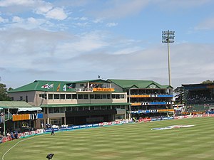
St George's Park Cricket Ground
Cricket ground
Distance: Approx. 2104 meters
Latitude and longitude: -33.96638889,25.61027778
St George's Park Cricket Ground (commonly known as St George's Park, Crusaders Ground or simply Crusaders) is a cricket ground in Gqeberha, (formerly known as Port Elizabeth), in South Africa. It is the home of the Port Elizabeth Cricket Club, one of the oldest cricket clubs in South Africa, the Eastern Province Club and Sunrisers Eastern Cape. It is also one of the venues at which Test matches and One Day Internationals are played in South Africa.
Roman Catholic Diocese of Port Elizabeth
Roman Catholic diocese in South Africa
Distance: Approx. 2106 meters
Latitude and longitude: -33.95,25.6
The Roman Catholic Diocese of Port Elizabeth (Latin: Portus Elizabethen(sis)) is a diocese located in the city of Port Elizabeth in the ecclesiastical province of Cape Town in South Africa.

Prince Alfred's Guard Memorial
Distance: Approx. 2131 meters
Latitude and longitude: -33.9639,25.6062
Prince Alfred's Guard Memorial is a provincial heritage site in St George's Park in Port Elizabeth in South Africa's Eastern Cape province. The memorial is situated on top of Port Elizabeth's second oldest reservoir. On November 6, 1907 the Honourable Edgar H Walton, MLA, Treasurer General of the Cape Colony, unveiled the memorial to the fallen of the Prince Alfred's Guard.

Horse Memorial
Provincial heritage site in Port Elizabeth, Eastern Cape, South Africa
Distance: Approx. 1788 meters
Latitude and longitude: -33.9622,25.6094
The Horse Memorial (Afrikaans: Perdstandbeeld) is a provincial heritage site in Port Elizabeth in the Eastern Cape province of South Africa, in memory of the horses that served and died during the Second Boer War, where Britain brought a large number of horses to South Africa. Designed by Joseph Whitehead, the life-sized bronze memorial features a kneeling soldier presenting a bucket of water to a service horse.
Nelson Mandela Metropolitan Art Museum
Art museums in Eastern Cape, South Africa
Distance: Approx. 1974 meters
Latitude and longitude: -33.965571,25.611339
Nelson Mandela Metropolitan Art Museum was opened on 22 June 1956 as the King George VI Art Gallery. It is located in St George's Park in Port Elizabeth, South Africa. It was renamed in December 2002 in honour of Nelson Mandela and in line with the name of the Nelson Mandela Bay Metropolitan Municipality, of which Port Elizabeth is a part.
Port Elizabeth railway station
Railway station in South Africa
Distance: Approx. 1127 meters
Latitude and longitude: -33.96055556,25.625
Port Elizabeth railway station is a railway station, located in Port Elizabeth, South Africa. In 1873, Prime Minister John Molteno of the Cape Colony commenced work on connecting Port Elizabeth to the developing national railway network, resulting in the station complex being located in the historic central district, near the harbour. The prosperity which followed the construction of railways to the interior earned for the port the designation of "the Liverpool of South Africa." The station was completed in 1875.

Fort Frederick, Eastern Cape
Fort in South Africa
Distance: Approx. 1784 meters
Latitude and longitude: -33.966588,25.621436
Fort Frederick in Port Elizabeth, South Africa, was built in 1799 in order to stop the French from conquering the Cape Colony during the Napoleonic wars and played a vital role in establishing British rule in South Africa in combination with the Battle of Blaauwberg. The fort has never fired a shot from its guns.
St. Augustine's Cathedral, Port Elizabeth
Church in Port Elizabeth, South Africa
Distance: Approx. 1240 meters
Latitude and longitude: -33.96173,25.62238
St. Augustine's Cathedral, also called the Catholic Cathedral of Port Elizabeth, is a Roman Catholic cathedral located on Prospect Hill in the city of Port Elizabeth, part of the Eastern Cape Province on the coast of the African country of South Africa. The first stone of the present Gothic structure was placed in 1861 under the impulse of Father Thomas Murphy; the church was finished and consecrated in 1866.
Baakens River
River in the Eastern Cape, South Africa
Distance: Approx. 1592 meters
Latitude and longitude: -33.96388889,25.62916667
The Baakens River, also known as Gqeberha River (Xhosa: [ᶢǃʱɛ̀ɓéːxà]), is a river that empties at Port Elizabeth's city centre and harbour in Algoa Bay. The river flows for about 23 km (14 mi) from its catchment area at Sherwood, Hunter's Retreat, and Rowallan Park through mainly urban area to its mouth. Mostly, it is a small quiet stream.

Donkin Memorial
Four-sided stone pyramid in South Africa
Distance: Approx. 1296 meters
Latitude and longitude: -33.96208,25.62049
The Donkin Memorial is a four-sided stone pyramid located in the Donkin Reserve, central Gqeberha, South Africa. It was constructed at the behest of Sir Rufane Donkin (acting governor of the Cape 1820–1821) in memory of his wife Elizabeth Donkin née Markam, who died in India in 1818. The pyramid measures 10 metres (33 ft) high and is constructed of local stone.
Weather in this IP's area
clear sky
14 Celsius
14 Celsius
14 Celsius
15 Celsius
1025 hPa
82 %
1025 hPa
1025 hPa
10000 meters
1.54 m/s
240 degree
06:15:08
18:09:39