Country:
 Democratic Republic of the Congo
Region:
City:
Latitude and Longitude:
Time Zone:
Postal Code:
IP information under different IP Channel
ip-api
Country
Region
City
ASN
Time Zone
ISP
Blacklist
Proxy
Latitude
Longitude
Postal
Route
IPinfo
Country
Region
City
ASN
Time Zone
ISP
Blacklist
Proxy
Latitude
Longitude
Postal
Route
MaxMind
Country
Region
City
ASN
Time Zone
ISP
Blacklist
Proxy
Latitude
Longitude
Postal
Route
Luminati
Country
CDASN
Time Zone
Africa/Lubumbashi
ISP
OLIVERSOFT
Latitude
Longitude
Postal
db-ip
Country
Region
City
ASN
Time Zone
ISP
Blacklist
Proxy
Latitude
Longitude
Postal
Route
ipdata
Country
Region
City
ASN
Time Zone
ISP
Blacklist
Proxy
Latitude
Longitude
Postal
Route
Popular places and events near this IP address

Karisimbi (commune)
Commune in Goma, North Kivu
Distance: Approx. 4996 meters
Latitude and longitude: -1.63333,29.18333
Karisimbi is a commune of the city of Goma in the North Kivu Province of the eastern region of the Democratic Republic of the Congo. It is named after the nearby Mount Karisimbi.

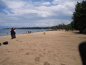
Goma
Provincial capital and city in North Kivu, DR Congo
Distance: Approx. 2750 meters
Latitude and longitude: -1.67944444,29.23361111
Goma is the capital and largest city of the North Kivu Province in the eastern region of the Democratic Republic of the Congo. It is located on the northern shore of Lake Kivu and shares borders with Bukumu Chiefdom to the north, Rwanda to the east and Masisi Territory to the west. The city lies in the Albertine Rift, the western branch of the East African Rift, and is only 13–18 km (8.1–11.2 mi) south of the active volcano Mount Nyiragongo.
Gisenyi
City in Western Province, Rwanda
Distance: Approx. 5667 meters
Latitude and longitude: -1.7,29.25
Gisenyi, historically rendered as Kisenyi, is the second largest city in Rwanda, located in the Rubavu district in Rwanda's Western Province. Gisenyi is contiguous with Goma, the city across the border in the Democratic Republic of the Congo.
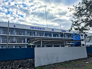
University of Goma
University in the DRC
Distance: Approx. 2173 meters
Latitude and longitude: -1.6777,29.217
The University of Goma (French: Université de Goma, colloquially denoted by its acronym UNIGOM) is a public university strategically situated in Goma, within the North Kivu Province of the eastern region of the Democratic Republic of the Congo. UNIGOM was established in 1993 as the Centre Universitaire du Nord-Kivu (CUNK) and later elevated to university status in 2005. It offers education primarily in French and aims to provide quality education, conduct research, and serve the community.
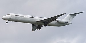
Hewa Bora Airways Flight 122
2008 aviation accident
Distance: Approx. 3307 meters
Latitude and longitude: -1.68138889,29.23944444
On 15 April 2008, Hewa Bora Airways Flight 122, a McDonnell Douglas DC-9-51 plane crashed into a residential and market area of Goma of the Democratic Republic of the Congo immediately south of Goma International Airport.
Umuganda Stadium
Distance: Approx. 5052 meters
Latitude and longitude: -1.6755,29.2626
The Stade Umuganda is a multi-use stadium in Gisenyi, Rwanda. It is currently used mostly for football matches, on club level by Etincelles FC and Marines F.C. of the Rwandan Premier League. The stadium has a capacity of 5,000 spectators.
Gisenyi Airport
Airport in Gisenyi, Rwanda
Distance: Approx. 4843 meters
Latitude and longitude: -1.68,29.258334
Gisenyi Airport is an airport in Rwanda. It has IATA airport code GYI (not to be confused with North Texas Regional Airport with FAA location identifier GYI).

Goma (commune)
Commune in Goma, North Kivu
Distance: Approx. 3909 meters
Latitude and longitude: -1.6933,29.2252
Goma is a commune of the city of Goma in the North Kivu Province of the eastern region of the Democratic Republic of the Congo. It encompasses the southernmost sector of the city, extending from the principal main road (referred to as National Road 2) towards the shores of Lake Kivu. As per a 2018 estimate, the commune had approximately 333,727 residents.

2013 Compagnie Africaine d'Aviation Fokker 50 crash
Plane crash in the Democratic Republic of the Congo
Distance: Approx. 3111 meters
Latitude and longitude: -1.68333333,29.23333333
On 4 March 2013, a Fokker 50 operated by Compagnie Africaine d'Aviation on a domestic cargo flight from Lodja to Goma, Democratic Republic of the Congo, crashed in poor weather on approach to Goma Airport. There were nine people on board, of which six were killed. No fatalities were reported on the ground, despite the aircraft crashing into a populated area.
Gasmeth Energy Gas Works
Distance: Approx. 6420 meters
Latitude and longitude: -1.70916667,29.24805556
The Gasmeth Energy Gas Works (GEGW) is a planned methane gas extraction and processing plant in Rwanda.
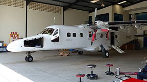
2019 Busy Bee Congo Dornier 228 crash
Plane crash in the Democratic Republic of the Congo
Distance: Approx. 3307 meters
Latitude and longitude: -1.68138889,29.23944444
On 24 November 2019, a Dornier 228-201 twin turboprop aircraft, operated by local carrier Busy Bee Congo, crashed shortly after takeoff from Goma International Airport in a densely populated section of the city, killing 21 of the 22 on board and 6 on the ground. It is the deadliest accident involving the Dornier 228.
Adventist University of Goma
Distance: Approx. 1975 meters
Latitude and longitude: -1.65856202,29.20275082
Adventist University of Goma is a private Christian co-educational school owned and operated by the Seventh-day Adventist Church in the Democratic Republic of Congo. The university is located in Goma, North Kivu, Democratic Republic of Congo. It is a part of the Seventh-day Adventist education system, the world's second largest Christian school system.
Weather in this IP's area
light rain
23 Celsius
23 Celsius
23 Celsius
23 Celsius
1013 hPa
66 %
1013 hPa
851 hPa
10000 meters
0.83 m/s
1.64 m/s
222 degree
98 %
05:43:47
17:52:43