Country:
 South Africa
Region:
City:
Latitude and Longitude:
Time Zone:
Postal Code:
IP information under different IP Channel
ip-api
Country
Region
City
ASN
Time Zone
ISP
Blacklist
Proxy
Latitude
Longitude
Postal
Route
IPinfo
Country
Region
City
ASN
Time Zone
ISP
Blacklist
Proxy
Latitude
Longitude
Postal
Route
MaxMind
Country
Region
City
ASN
Time Zone
ISP
Blacklist
Proxy
Latitude
Longitude
Postal
Route
Luminati
Country
ZARegion
nw
City
rustenburg
ASN
Time Zone
Africa/Johannesburg
ISP
Afr-ix Telecom Sau
Latitude
Longitude
Postal
db-ip
Country
Region
City
ASN
Time Zone
ISP
Blacklist
Proxy
Latitude
Longitude
Postal
Route
ipdata
Country
Region
City
ASN
Time Zone
ISP
Blacklist
Proxy
Latitude
Longitude
Postal
Route
Popular places and events near this IP address
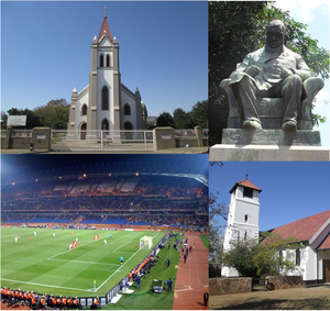
Rustenburg
City in North West province, South Africa
Distance: Approx. 1182 meters
Latitude and longitude: -25.66666667,27.24277778
Rustenburg (; Afrikaans pronunciation: [ˈrœstənbœrχ], Afrikaans and Dutch: City of Rest) is a city at the foot of the Magaliesberg mountain range. Rustenburg is the most populous city in North West province, South Africa (549,575 in 2011 and 626,522 in the 2016 census). In 2017, the city's Gross Domestic Product (GDP) reached ZAR 63.8 billion, accounting for 21.1% of the GDP of the North West Province, and 1.28% of the GDP of South Africa.
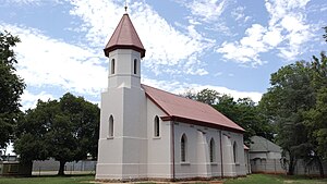
Kroondal
Place in North West, South Africa
Distance: Approx. 9064 meters
Latitude and longitude: -25.72527778,27.30777778
Kroondal is a village situated in North West Province of South Africa with a large German speaking community. It lies on the N4 road. The village originated from a farm in existence since 1843, initially known as Kronendal, on which a mission was established - one of 22 German Lutheran missions in Natal and the former Transvaal.
Mankwe
Place in North West, South Africa
Distance: Approx. 9507 meters
Latitude and longitude: -25.593,27.195
Mankwe is a small settlement north of Pilanesberg and Rustenburg in the North West province of South Africa. It falls under the Moses Kotane Local Municipality and the Bojanala District Municipality.
Olympia Park
Sports stadium in South Africa
Distance: Approx. 3082 meters
Latitude and longitude: -25.6625,27.22194444
Olympia Park Stadion is a multi-purpose stadium located in Rustenburg, South Africa. Not to be confused with the Royal Bafokeng Stadium, where the 2010 FIFA World Cup games were played, it is currently used mostly for football and rugby matches; it was utilized as a training field for teams participating in the 2010 FIFA World Cup after being upgraded to meet FIFA specifications.
Zinniaville
Place in North West, South Africa
Distance: Approx. 1840 meters
Latitude and longitude: -25.648,27.241
Zinniaville is a small suburb in the city of Rustenburg, in the North West Province of South Africa. Zinniaville is close to the world's two biggest platinum mines. It lies close to the old border of Bophuthatswana.
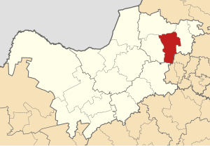
Rustenburg Local Municipality
Local municipality in North West, South Africa
Distance: Approx. 8127 meters
Latitude and longitude: -25.66666667,27.33333333
Rustenburg Municipality (Tswana: Mmasepala wa Rustenburg; Afrikaans: Rustenburg Munisipaliteit) is a local municipality within the Bojanala Platinum District Municipality, in the North West province of South Africa. Rustenburg is situated at the foot of the Magalies mountain range. Rustenburg (meaning "town of rest" or "resting place" in Afrikaans) was proclaimed a township in 1851.

Rustenburg Airfield
Airport
Distance: Approx. 2623 meters
Latitude and longitude: -25.64416667,27.27111111
Rustenburg Airfield (ICAO: FARG), licensed according to South African Civil Aviation Authority standards, is a municipal airport situated near Rustenburg in the North West province of South Africa.
Bathopele mine
Mine in Rustenburg, North West, South Africa
Distance: Approx. 6137 meters
Latitude and longitude: -25.6875,27.30611111
The Bathopele mine is a mechanised mine located in the north-western part of South Africa in Rustenburg, North West. Bathopele represents one of the largest platinum reserves in South Africa having estimated reserves of 5.3 million oz of platinum. The mine produces around 120,000 oz of platinum/year.

Kgaswane Mountain Reserve
Ramsar site reserve within the Magaliesberg Biosphere, North West, South Africa
Distance: Approx. 8424 meters
Latitude and longitude: -25.715,27.194
Kgaswane Mountain Reserve is a nature reserve of 5,300 hectares (13,000 acres) consisting of veld and mountains run by the North West Parks and Tourism Board. It is located 5 km (3.1 mi) south-west of Rustenburg on the northern slopes of the Magaliesberg, inside of the Magaliesberg Biosphere Reserve and alongside the western portion of the Magaliesberg Protected Natural Environment. Kgaswane is home to many species of flora and bird life and large and small mammals, and has been designated as a protected Ramsar site since 2019.
Weather in this IP's area
broken clouds
15 Celsius
13 Celsius
15 Celsius
15 Celsius
1013 hPa
24 %
1013 hPa
885 hPa
10000 meters
3.03 m/s
4.57 m/s
198 degree
72 %
06:03:40
18:05:52