Country:
 Ghana
GhanaRegion:
City:
Latitude and Longitude:
Time Zone:
Postal Code:
IP information under different IP Channel
ip-api
Country
Region
City
ASN
Time Zone
ISP
Blacklist
Proxy
Latitude
Longitude
Postal
Route
IPinfo
Country
Region
City
ASN
Time Zone
ISP
Blacklist
Proxy
Latitude
Longitude
Postal
Route
MaxMind
Country
Region
City
ASN
Time Zone
ISP
Blacklist
Proxy
Latitude
Longitude
Postal
Route
Luminati
Country
GHASN
Time Zone
Africa/Accra
ISP
UOEA-AS
Latitude
Longitude
Postal
db-ip
Country
Region
City
ASN
Time Zone
ISP
Blacklist
Proxy
Latitude
Longitude
Postal
Route
ipdata
Country
Region
City
ASN
Time Zone
ISP
Blacklist
Proxy
Latitude
Longitude
Postal
Route
Popular places and events near this IP address

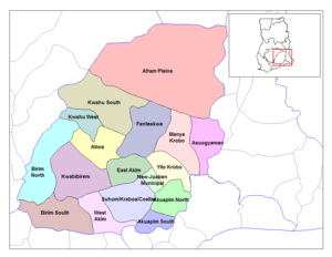
Yilo Krobo Municipal District
Municipal District in Ghana
Distance: Approx. 6132 meters
Latitude and longitude: 6.105,-0.016
Yilo Krobo Municipal District is one of the thirty-three districts in Eastern Region, Ghana. Originally created as an ordinary district assembly in 1988 when it was known as Yilo Krobo District, which it was created from the former Kaoga District Council, until it was elevated to municipal district assembly status on 6 February 2012 to become Yilo Krobo Municipal District. The municipality is located in the eastern part of Eastern Region and has Somanya as its capital town.

Somanya
Town in Eastern Region, Ghana
Distance: Approx. 5994 meters
Latitude and longitude: 6.10388889,-0.015
Somanya is a town and the capital of Yilo Krobo District, a district in the Eastern Region of south Ghana. Somanya has a 2013 settlement population of 20,596 people.And currently has a settlement population of 16,441,362 in the year 2021. Because the town is surrounded by a number of farming communities to the north of it, the name Somanya is used to encompass a collection of smaller communities around a bigger one.
Adukrom
Town in Eastern Region, Ghana
Distance: Approx. 8736 meters
Latitude and longitude: 6.0141,-0.0777
Adukrom is a town in the Okere District Assembly in the Eastern Region of Ghana. It shares borders with Awukugua Akuapem where Okomfo anokye was born The town is known for the Nifahene Stool of Akuapem and the capital of Okere District and situated on the Togo Atakora hills on the main Ho-Koforidua main trunk road in the northern part of Akuapem. It is also the political and administrative capital of the Okere Constituency which is currently represented in Parliament by the New Patriotic Party Member of Parliament, Hon.
Okere District
District in Ghana
Distance: Approx. 3319 meters
Latitude and longitude: 6.0788,-0.0173
Okere District is one of the thirty-three districts in Eastern Region, Ghana. Originally it was formerly part of the then-larger Akuapim North District in 1988, which was created from the former Akuapim District Council; until it was elevated to municipal district assembly status on 15 March 2012 to become Akuapim North Municipal District. However on 15 March 2018, the northeast part of the district was split off to create Okere District; thus the remaining part has been retained as Akuapim North Municipal District when the Legislative Instrument (L.I) 2342 in 2017 in pursuance to the Government’s Decentralization Policy and Local Government Reform Policy was implemented to split off the Okere District from the Akuapim North Municipal District.
Kaoga District
Former District Council in Ghana
Distance: Approx. 6132 meters
Latitude and longitude: 6.105,-0.016
Kaoga District is a former district council that was located in Eastern Region, Ghana. Originally created as an ordinary district assembly in 1975. However on 10 March 1989, it was split off into three new district assemblies: Yilo Krobo District (capital: Somanya), Manya Krobo District (capital: Odumase) and Asuogyaman District (capital: Atimpoku).
Weather in this IP's area
broken clouds
24 Celsius
24 Celsius
24 Celsius
24 Celsius
1014 hPa
93 %
1014 hPa
1005 hPa
10000 meters
1.65 m/s
2.38 m/s
221 degree
64 %
05:45:50
17:44:52