Country:
Region:
City:
Latitude and Longitude:
Time Zone:
Postal Code:
IP information under different IP Channel
ip-api
Country
Region
City
ASN
Time Zone
ISP
Blacklist
Proxy
Latitude
Longitude
Postal
Route
Luminati
Country
ASN
Time Zone
Africa/Nairobi
ISP
DCSL1-AS
Latitude
Longitude
Postal
IPinfo
Country
Region
City
ASN
Time Zone
ISP
Blacklist
Proxy
Latitude
Longitude
Postal
Route
db-ip
Country
Region
City
ASN
Time Zone
ISP
Blacklist
Proxy
Latitude
Longitude
Postal
Route
ipdata
Country
Region
City
ASN
Time Zone
ISP
Blacklist
Proxy
Latitude
Longitude
Postal
Route
Popular places and events near this IP address

Nairobi
Capital and largest city of Kenya
Distance: Approx. 225 meters
Latitude and longitude: -1.28638889,36.81722222
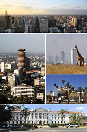
Nairobi ( ny-ROH-bee) is the capital and largest city of Kenya. The name is derived from the Maasai phrase Enkare Nairobi, which translates to 'place of cool waters', a reference to the Nairobi River which flows through the city. The city proper had a population of 4,397,073 in the 2019 census.
Jamia Mosque (Kenya)
Mosque in Nairobi, Kenya
Distance: Approx. 327 meters
Latitude and longitude: -1.2836,36.8207
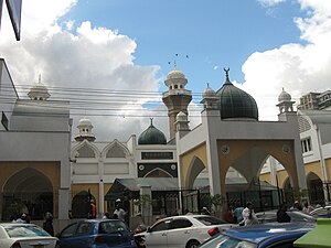
Jamia Mosque is a mosque located on Banda Street, Nairobi, Kenya in the Central Business District. Jamia Mosque is an important center of Islamic practice in the East and Central African region. As a landmark and heritage site at the heart of Nairobi’s CBD, Jamia Mosque-Nairobi displays an iconic image and an architectural masterpiece.
I&M Bank Tower
Commercial in Nairobi, Africa
Distance: Approx. 235 meters
Latitude and longitude: -1.284723,36.82
The I&M Bank Tower is a skyscraper in Nairobi, Kenya's capital and largest city. It was designed and constructed by Laxmanbhai Construction LTD and designed by Planning Systems Services Ltd under Lee Hun Wan & Sons. Its original design was drawn from Amsterdam's whirl shaped traditional modeling.

Roman Catholic Archdiocese of Nairobi
Roman Catholic archdiocese in Kenya
Distance: Approx. 411 meters
Latitude and longitude: -1.2871,36.8205
The Roman Catholic Archdiocese of Nairobi (Latin: Nairobien(sis)) is the Metropolitan See for the ecclesiastical province of Nairobi in Kenya, and the Primatial see for Kenya.

Nairobi City County
County of Kenya
Distance: Approx. 187 meters
Latitude and longitude: -1.2833,36.8167
Nairobi City County is one of the 47 counties of Kenya. With an estimated population of 5,454,000 in 2024, it is the third-smallest in area of the counties, yet the most populous one. It also serves as the capital of Kenya.

Nyayo House
Government Building in Nairobi, Kenya
Distance: Approx. 270 meters
Latitude and longitude: -1.2869,36.8181
Nyayo House is a skyscraper in Nairobi, Kenya. It hosts several government departments such as immigration (the State Department for Immigration, Border Control, and Regulation of Persons) and also serves as the headquarters of Nairobi Province. The building is located at the corner of Uhuru Highway and Kenyatta Avenue.
Timeline of Nairobi
Distance: Approx. 187 meters
Latitude and longitude: -1.283333,36.816667
The following is a timeline of the history of the city of Nairobi, Kenya.
Hazina Towers
Building in Nairobi, Kenya
Distance: Approx. 342 meters
Latitude and longitude: -1.282491,36.815562
Hazina Towers, also Hazina Trading Centre, is a building under construction in Nairobi, the capital and largest city in Kenya. The building was originally planned to be 39 storeys tall.
Housing Finance Group of Kenya
Distance: Approx. 186 meters
Latitude and longitude: -1.28511111,36.81944444
Housing Finance Group of Kenya (HFGK), also Housing Finance Group Limited (HFGL), is a financial services holding company based in Kenya. HFGK maintains its headquarters in Nairobi, the capital and largest city, with subsidiaries and branches in major urban centers in the country.

McMillan Memorial Library, Nairobi
Public library situated in Nairobi, Kenya
Distance: Approx. 382 meters
Latitude and longitude: -1.283587,36.821215
The McMillan Memorial Library is a public library situated in Nairobi, Kenya. It is the oldest library in Nairobi, and the second oldest in Kenya after the Seif bin Salim Library in Mombasa.
All Saints' Cathedral, Nairobi
Cathedral of the Anglican Church of Kenya
Distance: Approx. 247 meters
Latitude and longitude: -1.28666667,36.8175
All Saints' Cathedral, Nairobi is a Cathedral of the Anglican Church of Kenya (ACK).
Nairobi Gallery
Art Gallery in Nairobi, Kenya
Distance: Approx. 257 meters
Latitude and longitude: -1.286789,36.817833
The Nairobi Gallery (Swahili: Nyumba ya sanaa ya Nairobi) is an art gallery located an at the edge of the Nairobi central business district. The gallery is dedicated to showcasing African art.
Weather in this IP's area
overcast clouds
18 Celsius
19 Celsius
18 Celsius
18 Celsius
1015 hPa
92 %
1015 hPa
836 hPa
10000 meters
2.37 m/s
5.05 m/s
28 degree
100 %
06:12:25
18:22:56


