Country:
Region:
City:
Latitude and Longitude:
Time Zone:
Postal Code:
IP information under different IP Channel
ip-api
Country
Region
City
ASN
Time Zone
ISP
Blacklist
Proxy
Latitude
Longitude
Postal
Route
Luminati
Country
Region
02
City
daressalaam
ASN
Time Zone
Africa/Dar_es_Salaam
ISP
WANANCHI
Latitude
Longitude
Postal
IPinfo
Country
Region
City
ASN
Time Zone
ISP
Blacklist
Proxy
Latitude
Longitude
Postal
Route
db-ip
Country
Region
City
ASN
Time Zone
ISP
Blacklist
Proxy
Latitude
Longitude
Postal
Route
ipdata
Country
Region
City
ASN
Time Zone
ISP
Blacklist
Proxy
Latitude
Longitude
Postal
Route
Popular places and events near this IP address

Kivukoni
Ward of Ilala District, Dar es Salaam Region
Distance: Approx. 269 meters
Latitude and longitude: -6.8142,39.2901
Kivukoni (Kata ya Kivukoni, in Swahili) is an administrative ward of the Ilala Municipical Council of the Dar es Salaam Region in Tanzania. Kivikoni's name come from the Swahili word meaning "a crossing place". The ward is bordered by Upanga East ward to the west, Kisutu ward to the southwest, and Kigamboni ward across the Kivukoni channel.

Mafuta House
Distance: Approx. 220 meters
Latitude and longitude: -6.8151,39.288
Benjamin William Mkapa Pension Tower, formerly known as Mafuta House, is one of the tallest buildings in Dar es Salaam, Tanzania. It is a multi-million U.S. Dollar building owned by the National Social Security Fund (NSSF) that will be used for retail and commercial space. After a 5-year halt due to lack of funds by its previous owners, Tanzania Petroleum Development Corporation (TPDC) and the National Housing Corporation (NHC), its construction resumed in late 2004 when NSSF purchased the unfinished building and continued the construction.

Gerezani
Ward of Ilala District, Dar es Salaam Region
Distance: Approx. 289 meters
Latitude and longitude: -6.8183,39.2875
Gerezani (Kata ya Gerezani, in Swahili) is an administrative ward of the Ilala Municipical Council of the Dar es Salaam Region in Tanzania. The Kariakoo and Mchikichini wards border the ward on its northern side. The ward is bordered by Mchafukoge to the east.
CRDB Bank
Commercial bank in Tanzania
Distance: Approx. 268 meters
Latitude and longitude: -6.81486111,39.28763889
CRDB Bank Plc is a commercial bank in Tanzania. It is licensed by the Bank of Tanzania, the central bank and national banking regulator. As of September 2022, CRDB Bank was the largest commercial bank in Tanzania.

Azania Front Lutheran Church
Distance: Approx. 233 meters
Latitude and longitude: -6.8176,39.2912
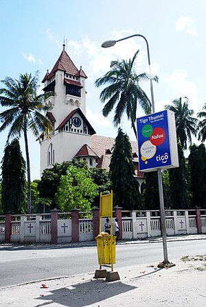
The Azania Front Lutheran Church is a Lutheran church in Dar es Salaam, Tanzania, serving as a cathedral for the local diocese. It is among the most well-known landmarks and tourist attractions of the city. It is in the city center, close to the ocean, facing the harbour.

Askari Monument
Military memorial in Dar es Salaam, Tanzania
Distance: Approx. 23 meters
Latitude and longitude: -6.8166341,39.2895626
The Askari Monument or Dar es Salaam African Memorial in Kivukoni Ward in Ilala District of Dar es Salaam, Tanzania, is a memorial to the askari (African soldiers) who fought in the British campaign against the German Army in East Africa in World War I. It was unveiled in 1927. The monument is located at the centre of a roundabout on Samora Avenue at the perpendicular junction to Maktaba Street and Azikiwe Street, a place that reportedly also marks the exact centre of downtown Dar es Salaam. The monument was erected in honour of the King's African Rifles and the Carrier Corps.
White Fathers' House
Distance: Approx. 256 meters
Latitude and longitude: -6.8187866,39.289088
The White Fathers' House (also known as Atiman House) is a historical building in Dar es Salaam, Tanzania. It is located in Sokoine Street, north-east of St. Joseph's Cathedral.

Ministry of Energy and Minerals
Distance: Approx. 313 meters
Latitude and longitude: -6.81527778,39.29194444
The Ministry of Energy and Minerals was the government ministry of Tanzania responsible for facilitating the development of the energy and mineral sectors. The Ministry was ultimately split in 2017 by President John Magufuli to tighten supervision on the two industries.
Ministry of Constitutional and Legal Affairs
Distance: Approx. 203 meters
Latitude and longitude: -6.81833333,39.28944444
The Ministry of Constitution and Legal Affairs is a government ministry of Tanzania that was formed in 2006. The ministry is responsible for creating and promoting good governance, justice, and equality by ensuring universal access to legal services.

Ministry of Energy (Tanzania)
Government ministry in Tanzania
Distance: Approx. 313 meters
Latitude and longitude: -6.81527778,39.29194444
The Ministry of Energy is the government ministry of Tanzania which is responsible for facilitating the development of the energy sectors.
Bank of Africa Tanzania
Tanzanian commercial bank
Distance: Approx. 302 meters
Latitude and longitude: -6.8175,39.29194444
Bank of Africa Tanzania Limited, also known as BOA Tanzania (BOAT), is one of the commercial banks in Tanzania that have been licensed by the Bank of Tanzania, the country's central bank and national banking regulator.

Ministry of Minerals (Tanzania)
Distance: Approx. 313 meters
Latitude and longitude: -6.81527778,39.29194444
The Ministry of Minerals is the government ministry of Tanzania which is responsible for facilitating the development of the mining sector.
Weather in this IP's area
scattered clouds
31 Celsius
34 Celsius
31 Celsius
31 Celsius
1009 hPa
55 %
1009 hPa
1007 hPa
10000 meters
5.14 m/s
50 degree
40 %
05:54:55
18:20:39