102.216.193.209 - IP Lookup: Free IP Address Lookup, Postal Code Lookup, IP Location Lookup, IP ASN, Public IP
Country:
Region:
City:
Location:
Time Zone:
Postal Code:
ISP:
ASN:
language:
User-Agent:
Proxy IP:
Blacklist:
IP information under different IP Channel
ip-api
Country
Region
City
ASN
Time Zone
ISP
Blacklist
Proxy
Latitude
Longitude
Postal
Route
db-ip
Country
Region
City
ASN
Time Zone
ISP
Blacklist
Proxy
Latitude
Longitude
Postal
Route
IPinfo
Country
Region
City
ASN
Time Zone
ISP
Blacklist
Proxy
Latitude
Longitude
Postal
Route
IP2Location
102.216.193.209Country
Region
abuja federal capital territory
City
maitama
Time Zone
Africa/Lagos
ISP
Language
User-Agent
Latitude
Longitude
Postal
ipdata
Country
Region
City
ASN
Time Zone
ISP
Blacklist
Proxy
Latitude
Longitude
Postal
Route
Popular places and events near this IP address

Abuja
Capital of the Federal Republic of Nigeria
Distance: Approx. 3622 meters
Latitude and longitude: 9.06666667,7.48333333
Abuja () is the capital city of the Federal Republic of Nigeria, strategically situated at the geographic midpoint of the country within the Federal Capital Territory (FCT). As the seat of the Federal Government of Nigeria, it hosts key national institutions, landmarks, and buildings spread across its over 50 districts. It replaced Lagos, (most populous city in Nigeria) as the capital on 12 December 1991.

Aso Rock
Monolith in Nigeria
Distance: Approx. 4364 meters
Latitude and longitude: 9.08333333,7.53611111
Aso Rock is a large outcrop of granitic rock located on the outskirts of Abuja, the capital of Nigeria. The Aso Rock is a 400-metre (1,300 ft) prominent monolith with a peak height of 936-metre (3,071 ft) above sea level. It is one of the city's most noticeable features.
Aso Villa
Official residence of the Nigerian president
Distance: Approx. 4320 meters
Latitude and longitude: 9.06227,7.518532
The Aso Rock Villa (officially Aso Rock Presidential Villa) is the workplace and official residence of the President of Nigeria since 1991, when Nigeria moved its capital from Lagos to Abuja. It is located at Yakubu Gowon Crescent, Asokoro District, Abuja in the Federal Capital Territory of Nigeria. The Aso Rock Villa hosts the offices of the President and Vice President and it is the seat of the Executive Arm of the Federal Government of Nigeria.

House of Representatives (Nigeria)
Lower house of the Nigerian National Assembly
Distance: Approx. 3370 meters
Latitude and longitude: 9.06805556,7.51111111
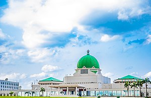
The House of Representatives (also called Green Chamber) is the lower chamber of Nigeria's bicameral National Assembly. The Senate is the upper chamber. The Green Chamber has 360 members who are elected in single-member constituencies using the plurality (or first-past-the-post) system, most recently in 2023.

Embassy of Germany, Abuja
Distance: Approx. 1821 meters
Latitude and longitude: 9.0979,7.482
The German Embassy in Abuja is Germany's diplomatic mission to Nigeria. The embassy is located at 9 Lake Maracaibo Close, off Amazon Street Maitama / Abuja F.C.T. The consulate-general is located in Lagos at 15, Walter Carrington Crescent, Victoria Island - Lagos, Nigeria. The embassy is also home to a consulate various departments and a military attaché.

Maitama
District in Abuja, Nigeria
Distance: Approx. 1439 meters
Latitude and longitude: 9.08449,7.491704
Maitama is a district in Phase 1 of Abuja, the capital city of Nigeria. The district hosts various foreign embassies, high commissions, and governmental buildings. It houses several of Abuja's most well known landmarks, such as the Millennium Park, Minister's Hill, the Unity Fountain, the IBB Golf Club, and the Transcorp Hilton.

Millennium Tower (Abuja)
Mixed-Use in FCT, Nigeria
Distance: Approx. 4468 meters
Latitude and longitude: 9.0558427,7.4928093
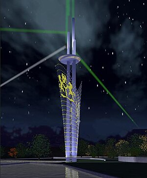
The Millennium Tower and Cultural Centre project is one of a number of projects in the Central District of Nigeria's capital city of Abuja. At 170 metres (560 ft), it is the tallest artificial structure in Abuja. The tower was designed by Manfredi Nicoletti and is part of the Nigeria National Complex which also includes the Nigerian Cultural Centre, an eight-storey, low rise, pyramid shaped Cultural Centre.
Ibrahim Babangida College of Agriculture
Distance: Approx. 4601 meters
Latitude and longitude: 9.06163296,7.47455372
The Ibrahim Babangida College of Agriculture is a tertiary educational institution in Obubra, Cross River State, Nigeria. 20 million naira was allocated for infrastructure development in 2001, but only 3.9 million was reported as spent. No further allocations were provided in 2002–2005.
Anglican Diocese of Abuja
Anglican diocese in Nigeria
Distance: Approx. 3622 meters
Latitude and longitude: 9.06666667,7.48333333
The Anglican Diocese of Abuja is one of 13 within the Anglican Province of Abuja, itself one of 14 provinces within the Church of Nigeria. As of March 2020, the bishop is Archbishop Henry Ndukuba, who is also Primate of the Church of Nigeria.

June 2014 Kaduna and Abuja attacks
Distance: Approx. 3620 meters
Latitude and longitude: 9.0667,7.4833
Between 23 and 25 June 2014, a series of attacks occurred in central Nigeria. On 23–24 June, gunmen attacked a number of villages in Kaduna State, killing around 150 people. The attack was blamed on Fulani tribesmen.
Nigerian Export-Import Bank
Nigerian export credit agency
Distance: Approx. 3753 meters
Latitude and longitude: 9.06222222,7.49361111
The Nigerian Export-Import Bank (NEXIM) is an export credit agency in Nigeria, established in 1991. In its function, NEXIM focuses on the development and expansion of the non-oil sectors of the Nigerian economy, with a view to reducing the country's over-reliance on oil exports.

Crushed Rock, Mpape
Abandoned quarry in Nigeria
Distance: Approx. 4297 meters
Latitude and longitude: 9.13416667,7.49666667
Crushed Rock is an abandoned quarry in Mpape, Abuja, the capital of Nigeria. The quarry was opened in 1977, just a year after the decision to relocate Nigeria's capital to Abuja from Lagos. During the 1980s the quarry provided much of the stone for the construction of the new city.
Weather in this IP's area
broken clouds
22 Celsius
21 Celsius
22 Celsius
22 Celsius
1009 hPa
20 %
1009 hPa
952 hPa
10000 meters
2.22 m/s
2.52 m/s
45 degree
82 %