Country:
Region:
City:
Latitude and Longitude:
Time Zone:
Postal Code:
IP information under different IP Channel
ip-api
Country
Region
City
ASN
Time Zone
ISP
Blacklist
Proxy
Latitude
Longitude
Postal
Route
Luminati
Country
Region
02
City
daressalaam
ASN
Time Zone
Africa/Dar_es_Salaam
ISP
WANANCHI
Latitude
Longitude
Postal
IPinfo
Country
Region
City
ASN
Time Zone
ISP
Blacklist
Proxy
Latitude
Longitude
Postal
Route
db-ip
Country
Region
City
ASN
Time Zone
ISP
Blacklist
Proxy
Latitude
Longitude
Postal
Route
ipdata
Country
Region
City
ASN
Time Zone
ISP
Blacklist
Proxy
Latitude
Longitude
Postal
Route
Popular places and events near this IP address
Kariakoo
Ward of Ilala District, Dar es Salaam Region
Distance: Approx. 844 meters
Latitude and longitude: -6.8197,39.273
Kariakoo (Kata ya Kariakoo, in Swahili) is an administrative ward of the Ilala Municipal Council of the Dar es Salaam Region in Tanzania. Jangwani ward and Mchafukoge ward form the ward's northern and eastern boundaries. The Gerezani and Mchikichini wards border the ward to the south and west respectively.

Magomeni
Ward of Kinondoni District, Dar es Salaam Region
Distance: Approx. 1039 meters
Latitude and longitude: -6.8108,39.2596
Magomeni (Kata ya Magomeni, in Swahili) is an administrative ward in Kinondoni District of the Dar es Salaam Region in Tanzania. The ward is surrounded on its northern side by the wards of Makumbusho, Mwananyamala, and Hananasif. The ward is bordered to the east by the Ilala MC wards of Upanga West and Mchikichini.

Jangwani
Ward of Ilala District, Dar es Salaam Region
Distance: Approx. 718 meters
Latitude and longitude: -6.8166,39.2743
Jangwani (Kata ya Jangawani, in Swahili) is an administrative ward of the Ilala Municipical Council of the Dar es Salaam Region in Tanzania. The Upanga East and Upanga West wards border the ward on its northern side. The ward is bordered by Mchafukoge and Kisutu to the east.

Mchikichini
Ward of Ilala District, Dar es Salaam Region
Distance: Approx. 1002 meters
Latitude and longitude: -6.8208,39.2633
Mchikichini (Kata ya Mchikichini, in Swahili) is an administrative ward of the Ilala Municipical Council of the Dar es Salaam Region in Tanzania. Upanga West forms the ward's northern boundary. Its eastern border is formed by Jangwani and Kariakoo.

Upanga West
Ward of Ilala District, Dar es Salaam Region
Distance: Approx. 1060 meters
Latitude and longitude: -6.8055,39.2738
Upanga West (Kata ya Upanga Magharibi, in Swahili) is an administrative ward of the Ilala Municipical Council of the Dar es Salaam Region in Tanzania. Hananasif of Kinondoni is the northern boundary of the ward. Upanga East borders the ward on the east, and Mchikichini, Mzimuni, and Jangwani border it on the south.

Muhimbili University of Health and Allied Sciences
University in Ilala District, Dar es Salaam Region
Distance: Approx. 824 meters
Latitude and longitude: -6.80777778,39.27333333
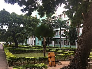
Muhimbili University of Health and Allied Sciences (MUHAS) ( Chuo Kikuu cha Afya na Sayansi Shirikishi Muhimbili, in Swahili) is a public university located in Upanga West, Ilala District of Dar es Salaam Region in Tanzania. It is accredited by the Tanzania Commission for Universities (TCU).

Dar es Salaam Institute of Technology
Educational institution in Tanzania
Distance: Approx. 317 meters
Latitude and longitude: -6.81067222,39.26891944
The Dar es Salaam Institute of Technology (DIT) is one of the high learning institutions in Tanzania. Originally established in 1957, it is fully accredited by the National Council for Technical Education (NACTE) to offer technician and engineering programmes leading to the awards of Ordinary Diploma(OD) in engineering, Bachelor of Engineering (BEng) respectively and Master of Engineering(MEng). Historically, DIT was established in 1997 by the Act of Parliament, “the DIT Act No.6 of 1997” to replace the Dar es Salaam Technical College, which had a long history of technical training in Tanzania.
Tanzania Buddhist Temple and Meditation Center
Distance: Approx. 1201 meters
Latitude and longitude: -6.805592,39.275993
Tanzania Buddhist Temple and Meditation Center is a Buddhist temple located in Dar es Salaam.

Dar es Salaam commuter rail
Public transit system in Tanzania
Distance: Approx. 378 meters
Latitude and longitude: -6.81629,39.266651
The Dar es Salaam commuter rail, informally known as Treni ya Mwakyembe ("Train of Mwakyembe"), is an urban and suburban commuter rail network serving the Tanzanian commercial city of Dar es Salaam. It is one of the two initiatives taken by the government to ease travel within the congested city; the other being the Dar es Salaam bus rapid transit system. Services are provided by the Tanzania-Zambia Railway Authority (TAZARA) and the Tanzania Railways Corporation (TRC).

Regency Medical Centre
Hospital in Dar es Salaam, Tanzania
Distance: Approx. 1179 meters
Latitude and longitude: -6.81297222,39.27925
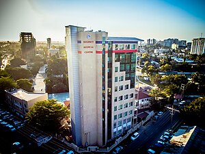
Regency Medical Centre is a multi-specialty hospital located on Aly Khan Road, in Dar es Salaam, Tanzania. Established in 1999, the hospital was founded by Dr. Rajni Kanabar, who was also the hospital's Chairman and the convener of the Tanzania Babies Heart Project till 25 June 2019.
Muhimbili National Hospital
Hospital in Dar es Salaam, Tanzania
Distance: Approx. 756 meters
Latitude and longitude: -6.80773,39.27221
Muhimbili National Hospital (Hospitali ya Taifa ya Muhimbili, in Swahili) is a 1500-bed public teaching hospital located in Upanga West ward of Ilala District in Dar es Salaam Region of Tanzania. It is the national referral hospital as well as academic and research facility for the Muhimbili University of Health and Allied Sciences. It offers speciality care across the spectrum of clinical medicine.
International Commercial Bank Tanzania
Commercial bank in Tanzania
Distance: Approx. 1015 meters
Latitude and longitude: -6.81361111,39.27777778
International Commercial Bank Tanzania Limited (ICBT), is a commercial bank in Tanzania, the third-largest economy in the East African Community. It is licensed by the Bank of Tanzania, the country's central bank and national banking regulator.
Weather in this IP's area
scattered clouds
31 Celsius
33 Celsius
31 Celsius
31 Celsius
1008 hPa
51 %
1008 hPa
1008 hPa
10000 meters
5.24 m/s
5.48 m/s
94 degree
41 %
05:55:00
18:20:44
