Country:
Region:
City:
Latitude and Longitude:
Time Zone:
Postal Code:
IP information under different IP Channel
ip-api
Country
Region
City
ASN
Time Zone
ISP
Blacklist
Proxy
Latitude
Longitude
Postal
Route
Luminati
Country
ASN
Time Zone
Africa/Nairobi
ISP
FLL2-AS
Latitude
Longitude
Postal
IPinfo
Country
Region
City
ASN
Time Zone
ISP
Blacklist
Proxy
Latitude
Longitude
Postal
Route
db-ip
Country
Region
City
ASN
Time Zone
ISP
Blacklist
Proxy
Latitude
Longitude
Postal
Route
ipdata
Country
Region
City
ASN
Time Zone
ISP
Blacklist
Proxy
Latitude
Longitude
Postal
Route
Popular places and events near this IP address

Mombasa
City in Mombasa County, Kenya
Distance: Approx. 1896 meters
Latitude and longitude: -4.05,39.66666667
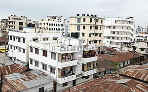
Mombasa ( mom-BASS-ə; also US: -BAH-sə) is a coastal city in southeastern Kenya along the Indian Ocean. It was the first capital of British East Africa, before Nairobi was elevated to capital status in 1907. It now serves as the capital of Mombasa County.

Fort Jesus
Fort located on Mombasa Island, Kenya
Distance: Approx. 180 meters
Latitude and longitude: -4.06273611,39.67963611
Fort Jesus (Portuguese: Forte Jesus de Mombaça, Spanish: Fuerte de Jesús) is a fort located on Mombasa Island. Designed by the Italian architect Giovanni Battista Cairati, it was built between 1593 and 1596 by order of King Felipe II of Spain, who also reigned as King Filipe I of Portugal and the Algarves, to guard the Old Port of Mombasa. Fort Jesus is the only fort maintained by the Portuguese on the Swahili coast and is recognised as a testament to the first successful attempt by a Western power to establish influence over the Indian Ocean trade.
2007 IAAF World Cross Country Championships
International athletics championship event
Distance: Approx. 1244 meters
Latitude and longitude: -4.07222222,39.67833333
The 2007 IAAF World Cross Country Championships took place on March 24, 2007. The races were held at the Mombasa Golf Course in Mombasa, Kenya. Four races took place, one for men, women, junior men and junior women respectively.

Moi Avenue (Mombasa)
Distance: Approx. 1283 meters
Latitude and longitude: -4.06166667,39.66805556
Moi Avenue is a primary thoroughfare in Mombasa, Kenya. The road runs from west to east from Kilindini to a roundabout with Digo Road. Originally called the Kilindini Road, its name was later changed in recognition of Kenya's second President, Daniel arap Moi.
Mombasa Old Town
Place in Mombasa County, Kenya
Distance: Approx. 435 meters
Latitude and longitude: -4.05888889,39.67638889
Old Town is an area of Mombasa, Kenya. Situated on the south-east side of Mombasa Island, the Old Town covers an area of 72 hectares (180 acres), and is inhabited by a mix of Swahili, Arab, Asian, Portuguese and British settlers. In 1997, the Old Town and Fort Jesus were submitted by the National Museums of Kenya for selection in UNESCO's list of World Heritage Sites.
Aga Khan Hospital, Mombasa
Hospital in Mombasa, Kenya
Distance: Approx. 1428 meters
Latitude and longitude: -4.070149,39.670471
Established in 1944, the Aga Khan Hospital, in Mombasa Kenya, is part of the Aga Khan Health Services (AKHS). It is a 96-bed acute care facility offering health care. The hospital provides general medical services, specialist clinics and high-tech diagnostic services.

Majengo, Mombasa
Place in Mombasa County, Kenya
Distance: Approx. 1717 meters
Latitude and longitude: -4.04861111,39.67055556
Majengo is a ward of Mombasa city, Kenya, located on Mombasa Island. It is estimated to have a population of 38,800 in 2011. It is divided between in the Kisauni and Mvita electoral constituencies.
Nyali
Place in Mombasa County, Kenya
Distance: Approx. 1868 meters
Latitude and longitude: -4.05,39.667
Nyali is a residential area and Sub-County within Mombasa City, located on the mainland north of Mombasa County. It is connected to Mombasa Island by the New Nyali Bridge. Nyali is known for its many high-class hotels and residential houses, modern standards, and long white sand beaches making it a popular destination for both local and foreign tourists.
Coast Gymkhana Club Ground
Distance: Approx. 1203 meters
Latitude and longitude: -4.065125,39.66953333
Coast Gymkhana Club Ground is a cricket ground in Mombasa, Kenya. The first recorded match held on the ground came in 1999 when a Coast Cricket Association XI played the touring Marylebone Cricket Club. The ground held its first List A match in 2010 when Kenya played the United Arab Emirates.
Holy Ghost Cathedral, Mombasa
Church in Mombasa, Kenya
Distance: Approx. 930 meters
Latitude and longitude: -4.063553,39.671585
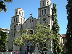
The Holy Ghost Cathedral or just Mombasa Cathedral, is the main place of Catholic worship in the city of Mombasa, Kenya, and the seat of the Bishop of the Archdiocese of Mombasa. The first "Catholic mission" of Mombasa was founded in 1889 by Father Alexander le Roy, a Missionary of the Holy Spirit. The residence and the chapel of the first missionaries was in Ndia Kuu (the ancient city of Mombasa), but in 1895 the living conditions had become unbearable, and it was necessary to build a larger building.

Mombasa Hospital
Hospital in Coast Province, Kenya
Distance: Approx. 475 meters
Latitude and longitude: -4.065212,39.680814
The Mombasa Hospital, established by the British in 1891 as the English Hospital, is the oldest and largest private hospital in Coast Province of Kenya. It is located in the Kinzingo area of Mombasa and is accredited by the Kenyan Ministry of Health as a Level 4 hospital.

Mombasa tusks
Aluminum monument in Mombasa, Kenya
Distance: Approx. 1500 meters
Latitude and longitude: -4.0615,39.6661
The Mombasa Tusks, also referred to as Mapembe ya Ndovu or Mapembeni or Pembe za Ndovu (Swahili for elephant tusks), form a monument over Moi Avenue, a major thoroughfare in Mombasa, Kenya. Built in the 1950s to commemorate visits by the British royal family, the monument originally comprised two wooden structures resembling tusks; nowadays, there are four aluminium tusks in an M shape. The monument is under the jurisdiction of the National Museums of Kenya in addition to the city's municipal government.
Weather in this IP's area
few clouds
31 Celsius
35 Celsius
31 Celsius
31 Celsius
1009 hPa
58 %
1009 hPa
1007 hPa
10000 meters
5.14 m/s
140 degree
20 %
05:57:10
18:15:17


