Country:
Region:
City:
Latitude and Longitude:
Time Zone:
Postal Code:
IP information under different IP Channel
ip-api
Country
Region
City
ASN
Time Zone
ISP
Blacklist
Proxy
Latitude
Longitude
Postal
Route
Luminati
Country
ASN
Time Zone
Africa/Nairobi
ISP
Click-Fiber-AS
Latitude
Longitude
Postal
IPinfo
Country
Region
City
ASN
Time Zone
ISP
Blacklist
Proxy
Latitude
Longitude
Postal
Route
db-ip
Country
Region
City
ASN
Time Zone
ISP
Blacklist
Proxy
Latitude
Longitude
Postal
Route
ipdata
Country
Region
City
ASN
Time Zone
ISP
Blacklist
Proxy
Latitude
Longitude
Postal
Route
Popular places and events near this IP address

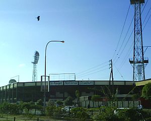
Nyayo National Stadium
Multi-purpose stadium in Nairobi, Kenya
Distance: Approx. 2449 meters
Latitude and longitude: -1.30419444,36.82447222
Nyayo National Stadium is a multi-purpose stadium in Nairobi, Kenya. It is located at the square of Mombasa Road, Langata Road and the Aerodrome Road. It is approximately two kilometers from the City Center, directly opposite Nairobi Mega Mall, formerly known as Nakumatt Mega.
Solar Ice Rink
Distance: Approx. 2008 meters
Latitude and longitude: -1.329034,36.855821
The Solar Ice Rink is an ice rink located in Nairobi, Kenya. The rink is located in the Panari Sky Centre, a large retail, leisure and hotel accommodation complex. Opened in 2005, the Solar Ice Rink is the largest rink in Africa, and the first rink in East Africa and Central Africa.
South C
Residential estate in Nairobi, Kenya
Distance: Approx. 1801 meters
Latitude and longitude: -1.317,36.825
South C or South Compton ( during colonial times) is a upper-class residential estate located in the southland area of Nairobi. South C lies next to Wilson Airport. It is bordered by South B to the north-east, Langata Estate to the west and the Nairobi National Park to the south.
African Airlines Association
African industry association
Distance: Approx. 753 meters
Latitude and longitude: -1.325,36.83888889
The African Airlines Association (French: Association des Compagnies Aériennes Africaines), abbreviated AFRAA, is a trade association of African airlines. AFRAA was founded in Accra, Ghana, in 1968, and is, as of February 2021, headquartered in Nairobi, Kenya. The primary purpose of AFRAA is to establish and facilitate co-operation between African airlines.
National Oil Corporation of Kenya
State corporation of Kenya
Distance: Approx. 1247 meters
Latitude and longitude: -1.325,36.8319
The National Oil Corporation of Kenya (NOCK), is a state corporation of Kenya founded by Act of Parliament in 1981, with a mandate of participating in all aspects of the Kenyan petroleum industry. The company was incorporated in 1981 and began operations in 1984.
Highway Secondary School
School
Distance: Approx. 488 meters
Latitude and longitude: -1.317529,36.836854
The Highway Secondary is a public boys' boarding school located in Nairobi's South B suburb, Kenya. The school is named for the Mombasa Highway that runs along the school's southern perimeter. The school is classified as an Extra County school.
South B
Distance: Approx. 1316 meters
Latitude and longitude: -1.31,36.833
South B is the name of a Division of the sub-county of Starehe in Nairobi, Kenya and the name of a "sub-location" of Mukuru Nyayo within the Division. The 2019 Kenya Census gives a population of 102,441 for South B Division and 34,216 for the sub-location. South B is about 3 kilometres (1.9 mi) south-east of Nairobi Central Business District; the Industrial Area lies to the east and the South C district to the south-west.
2011 Safari Sevens
Distance: Approx. 2449 meters
Latitude and longitude: -1.30419444,36.82447222
The 2011 Safari Sevens were the 16th annual edition of the Safari Sevens.
2012 Safari Sevens
Distance: Approx. 2449 meters
Latitude and longitude: -1.30419444,36.82447222
The 2012 Safari Sevens are the 17th annual edition of the Safari Sevens.
2013 Safari Sevens
Distance: Approx. 2449 meters
Latitude and longitude: -1.30419444,36.82447222
The 2013 Safari Sevens are the 18th annual edition of the Safari Sevens.
Kenya Electricity Transmission Company
Kenyan electricity transmission company
Distance: Approx. 1149 meters
Latitude and longitude: -1.32472222,36.83277778
Kenya Electricity Transmission Company Limited, commonly referred to as KETRACO, is a wholly-owned parastatal of the Government of Kenya which serves as the primary Transmission System Operator in the Republic of Kenya.
Nairobi West
Area of Nairobi, Kenya
Distance: Approx. 2600 meters
Latitude and longitude: -1.31055556,36.81916667
Nairobi West is a neighbourhood in the city of Nairobi. It is approximately 2.7 kilometres (1.7 mi) southwest of the central business district of Nairobi.
Weather in this IP's area
overcast clouds
18 Celsius
19 Celsius
18 Celsius
18 Celsius
1016 hPa
93 %
1016 hPa
839 hPa
10000 meters
2.17 m/s
4.89 m/s
27 degree
100 %
06:12:16
18:22:53