Country:
 Togo
TogoRegion:
City:
Latitude and Longitude:
Time Zone:
Postal Code:
IP information under different IP Channel
ip-api
Country
Region
City
ASN
Time Zone
ISP
Blacklist
Proxy
Latitude
Longitude
Postal
Route
IPinfo
Country
Region
City
ASN
Time Zone
ISP
Blacklist
Proxy
Latitude
Longitude
Postal
Route
MaxMind
Country
Region
City
ASN
Time Zone
ISP
Blacklist
Proxy
Latitude
Longitude
Postal
Route
Luminati
Country
TGRegion
m
City
lome
ASN
Time Zone
Africa/Lome
ISP
ST-Digital-AS
Latitude
Longitude
Postal
db-ip
Country
Region
City
ASN
Time Zone
ISP
Blacklist
Proxy
Latitude
Longitude
Postal
Route
ipdata
Country
Region
City
ASN
Time Zone
ISP
Blacklist
Proxy
Latitude
Longitude
Postal
Route
Popular places and events near this IP address

Lomé
Capital and largest city of Togo
Distance: Approx. 969 meters
Latitude and longitude: 6.13083333,1.21527778
Lomé (UK: LOH-may, US: loh-MAY) is the capital and largest city of Togo. It has an urban population of 837,437 while there were 2,188,376 permanent residents in its metropolitan area as of the 2022 census. Located on the Gulf of Guinea at the southwest corner of the country, with its entire western border along the easternmost edge of Ghana's Volta Region, Lomé is the country's administrative and industrial center, which includes an oil refinery.

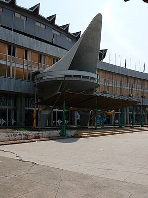
Hotel 2 Fevrier Lomé
Hotel in Lomé, Togo
Distance: Approx. 1183 meters
Latitude and longitude: 6.127645,1.214083
The Hôtel 2 Février is a 102m, 36-story hotel in Lomé, Togo on Place De L'Indépendance street, opened in 1980. It is the tallest building in Togo. Because it is the only high-rise in Lomé (and in Togo), it is visible from just about anywhere in the city.
Roman Catholic Archdiocese of Lomé
Roman Catholic archdiocese in Togo
Distance: Approx. 788 meters
Latitude and longitude: 6.1249,1.2263
The Roman Catholic Archdiocese of Lomé (Latin: Lomen(sis)) is the Metropolitan See for the ecclesiastical province of Lomé in Togo.
Togo National Museum
Museum in Togo
Distance: Approx. 743 meters
Latitude and longitude: 6.1304,1.2174
Togo National Museum (French: Musée national du Togo) is the national museum of Togo, located in the capital of Lomé. Founded in 1975, it features cultural and historical exhibits. The museum showcases artifacts dating back thousands of years, including musical instruments such as the xalam, baskets decorated with shells and calabashes used to preserve food and water, clay pots, wood carvings, clothes, metalwork, and tobacco pipes.

Lomé Grand Market
Public market in Lomé, Togo
Distance: Approx. 683 meters
Latitude and longitude: 6.1256261,1.2254183
The Lomé Grand Market (French: Grand marché de Lomé) is a public market in Lomé, the capital of Togo. It is located near the famous Sacred Heart Cathedral of Lomé, at the heart of the city. It occupies an entire city block and consists of three sections: Atipoji, Asigame and Assivito.
Tokoin
Neighborhood of Lomé, Togo
Distance: Approx. 2203 meters
Latitude and longitude: 6.15,1.21666667
Tokoin is a neighborhood of Lomé, Togo. It contains the Tokoin Teaching Hospital, and Lomé–Tokoin Airport.

1963 Togolese coup d'état
Coup that assassinated President Sylvanus Olympio
Distance: Approx. 141 meters
Latitude and longitude: 6.13194444,1.22277778
The 1963 Togolese coup d'état was a military coup that occurred in the West African country of Togo on 13 January 1963. The coup leaders — notably Emmanuel Bodjollé, Étienne Eyadéma (later Gnassingbé Eyadéma) and Kléber Dadjo — took over government buildings, arrested most of the cabinet, and assassinated Togo's first president, Sylvanus Olympio, outside the American embassy in Lomé. The coup leaders quickly brought Nicolas Grunitzky and Antoine Meatchi, both of whom were exiled political opponents of Olympio, together to form a new government.
Sacred Heart Cathedral, Lomé
Church in Lomé, Togo
Distance: Approx. 767 meters
Latitude and longitude: 6.125,1.226
The Sacred Heart Cathedral (French: Cathédrale du Sacré-Cœur de Lomé) is the cathedral of the Roman Catholic Archdiocese of Lomé (since 14 September 1955), one of the seven Catholic church districts of Togo. Built in just over a year (April 1901 to September 1902) by the German colonial authorities, it quickly became one of the iconic buildings of the new capital of Togo.
List of ambassadors of China to Togo
Distance: Approx. 1392 meters
Latitude and longitude: 6.129189,1.236341
The Chinese Ambassador to Togo is the official representative of the People's Republic of China to the Togolese Republic.

Independence Monument (Togo)
Monument in Lomé, Togo
Distance: Approx. 903 meters
Latitude and longitude: 6.13,1.216
The Independence Monument (French: Monument de l'Indépendance) in Lomé, the capital of Togo, was built as a tribute to the country's independence from France on 27 April 1960. It features a white bust of a woman holding up a cooking pot, in front of a silhouette of a figure holding up their arms as if they were breaking chains that shackled them together. The sides of the silhouette bear a number of inscriptions, including one which says in French: "People of Togo, because of your faith and sacrifice, the Togolese nation was born." Another side bears the national motto and the following inscription: "Proclamation of the independence of Togo, 27 April 1960.
1967 Togolese coup d'état
1967 coup in Togo
Distance: Approx. 141 meters
Latitude and longitude: 6.13194444,1.22277778
The 1967 Togolese coup d'état was a bloodless military coup that occurred in the West African country of Togo on 13 January 1967. The leader of the coup, Lieutenant Colonel Étienne Eyadéma (later General Gnassingbé Eyadéma) ousted Togo's second President, Nicolas Grunitzky, whom he essentially brought to power following the 1963 coup d'état. Following the coup, political parties were banned, and all constitutional processes were suspended.
1986 Togolese coup attempt
1986 coup attempt in Togo
Distance: Approx. 141 meters
Latitude and longitude: 6.13194444,1.22277778
The 1986 Togolese coup d'état attempt was a coup attempt that occurred in the West African country of Togo on 23 September 1986. The coup attempt consisted of a group of some 70 armed dissidents crossed into capital Lomé from Ghana in an unsuccessful attempt to overthrow the government of President General Gnassingbé Eyadéma.
Weather in this IP's area
few clouds
24 Celsius
25 Celsius
24 Celsius
24 Celsius
1013 hPa
94 %
1013 hPa
1012 hPa
10000 meters
20 %
05:40:53
17:39:11