102.185.133.212 - IP Lookup: Free IP Address Lookup, Postal Code Lookup, IP Location Lookup, IP ASN, Public IP
Country:
Region:
City:
Location:
Time Zone:
Postal Code:
IP information under different IP Channel
ip-api
Country
Region
City
ASN
Time Zone
ISP
Blacklist
Proxy
Latitude
Longitude
Postal
Route
Luminati
Country
Region
gz
City
dokki
ASN
Time Zone
Africa/Cairo
ISP
RAYA Telecom - Egypt
Latitude
Longitude
Postal
IPinfo
Country
Region
City
ASN
Time Zone
ISP
Blacklist
Proxy
Latitude
Longitude
Postal
Route
IP2Location
102.185.133.212Country
Region
ad daqahliyah
City
al mansurah
Time Zone
Africa/Cairo
ISP
Language
User-Agent
Latitude
Longitude
Postal
db-ip
Country
Region
City
ASN
Time Zone
ISP
Blacklist
Proxy
Latitude
Longitude
Postal
Route
ipdata
Country
Region
City
ASN
Time Zone
ISP
Blacklist
Proxy
Latitude
Longitude
Postal
Route
Popular places and events near this IP address
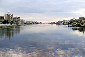
Mansoura, Egypt
City in Dakahlia, Egypt
Distance: Approx. 1522 meters
Latitude and longitude: 31.05,31.38333333
Mansoura (Arabic: المنصورة; Al Manṣūra, IPA: [el.mɑnˈsˤuːɾɑ], rural: [el.mænˈsˤuːɾe]) is a city in Egypt located on the eastern bank of the Damietta branch of the Nile river. The city is the capital of the Dakahlia Governorate and has a population of 621,953 as of 2021.

Battle of Mansurah (1250)
Part of the Seventh Crusade
Distance: Approx. 1027 meters
Latitude and longitude: 31.0456,31.3826
The Battle of Mansurah was fought from 8 to 11 February 1250, between Crusaders led by Louis IX, King of France, and Ayyubid forces led by Sultana Shajar al-Durr, vizier Fakhr ad-Din ibn as-Shaikh, Faris ad-Din Aktai, Baibars al-Bunduqdari and Qutuz. It was fought in present-day Mansoura, Egypt. The Crusader force was enticed into entering the town where it was set upon by the Muslim force.
El Mansoura Stadium
Distance: Approx. 2252 meters
Latitude and longitude: 31.0375,31.35722222
El-Mansoura Stadium is a multi-use stadium in El Mansoura, Egypt. It is used mostly for football matches, and hosts the home games of El Mansoura SC. The stadium holds 18,000 people. It opened in 1962.
Air battle of Mansoura
1973 battle of the Yom Kippur War
Distance: Approx. 565 meters
Latitude and longitude: 31.04083333,31.38388889
The air battle of Mansoura was an air battle that took place in 1973 during the Yom Kippur War between the Egyptian Air Force (EAF) and the Israeli Air Force (IAF) near the town of El Mansoura, in the Nile Delta. The Israeli air force launched air strikes on October 14 against the Egyptian air bases at Tanta and Mansoura. Israeli aircraft were spotted approaching from the Mediterranean Sea.
Dakahlia Governorate
Governorate of Egypt
Distance: Approx. 1522 meters
Latitude and longitude: 31.05,31.38333333
Dakahlia Governorate (Arabic: محافظة الدقهلية Muḥāfaẓah el Daqahliyah, pronounced [ed.dæʔæhˈlejjæ]) is an Egyptian governorate lying northeast of Cairo, Egypt. Its area is approximately 3,500 km2. Although the capital of the governorate is Mansoura, it got its name from the ancient town of Daqahlah (Arabic: دقهلة, from Coptic: ⲧⲕⲉϩⲗⲓ, lit. 'shrine') which is located in the modern Damietta Governorate.
Talkha
City in Dakahlia, Egypt
Distance: Approx. 2089 meters
Latitude and longitude: 31.054735,31.375644
Talkha (Arabic: طلخا pronounced [ˈtˤɑlxɑ]) is a city in Dakahlia Governorate, Egypt. The city is located on the west bank of the Damietta, a distributary of the Nile in the Delta region. Is about 120 km northeast of Cairo.

Behbeit El Hagar
Village in Gharbia Governorate, Egypt
Distance: Approx. 8952 meters
Latitude and longitude: 31.02777778,31.2875
Behbeit El Hagar (Ancient Egyptian: Pr-ḥꜣbyt(.t), lit. 'house of festival hall', Coptic: ⲡⲁϩⲃⲉⲓⲑⲓⲟⲥ, Ancient Greek: Πααβηιθις) is a village and an archaeological site in Lower Egypt that contains the remains of an ancient Egyptian temple to the goddess Isis, known as the Iseion. The village and the site lie in Gharbia Governorate along the Damietta branch of the Nile, 7 kilometers (4.5 mi) northeast of Sebennytos and 8 kilometers (5 mi) west of Mansoura. In ancient times it was part of the nome of Sebennytos, the Twelfth Lower Egyptian Nome.

Chemins de fer de la Basse-Egypte
Distance: Approx. 2555 meters
Latitude and longitude: 31.016088,31.393039
The Chemins de fer de la Basse-Egypte built and operated a network of up to seven lines of metre-gauge (1,000 mm, 3 ft 3+3⁄8 in) railway track in the area around Mansourah in Egypt.
Al Mansurah Air Base
Distance: Approx. 9378 meters
Latitude and longitude: 30.965,31.43277778
Al Mansurah Air Base is an Egyptian Air Force airbase located within Dakahlia Governorate, Egypt. The air base is home to both No. 57 Squadron and No.
Weather in this IP's area
scattered clouds
11 Celsius
11 Celsius
11 Celsius
11 Celsius
1015 hPa
95 %
1015 hPa
1015 hPa
10000 meters
3.87 m/s
8.48 m/s
247 degree
26 %

