Country:
 Great Britain
Region:
City:
Latitude and Longitude:
Time Zone:
Postal Code:
IP information under different IP Channel
ip-api
Country
Region
City
ASN
Time Zone
ISP
Blacklist
Proxy
Latitude
Longitude
Postal
Route
IPinfo
Country
Region
City
ASN
Time Zone
ISP
Blacklist
Proxy
Latitude
Longitude
Postal
Route
MaxMind
Country
Region
City
ASN
Time Zone
ISP
Blacklist
Proxy
Latitude
Longitude
Postal
Route
Luminati
Country
GBRegion
eng
City
marylebone
ASN
Time Zone
Europe/London
ISP
COGENT-174
Latitude
Longitude
Postal
db-ip
Country
Region
City
ASN
Time Zone
ISP
Blacklist
Proxy
Latitude
Longitude
Postal
Route
ipdata
Country
Region
City
ASN
Time Zone
ISP
Blacklist
Proxy
Latitude
Longitude
Postal
Route
Popular places and events near this IP address

Regent's Park tube station
London Underground station
Distance: Approx. 23 meters
Latitude and longitude: 51.5235,-0.1464
Regent's Park is a London Underground station 175 metres (191 yd) south of Regent's Park. It is on the Bakerloo line between Baker Street and Oxford Circus stations. Its access is on Marylebone Road, within Park Crescent, in Travelcard Zone 1, in which zone it is the second-least used station (least-used is Lambeth North) – it saw 3.5 million entries or exits in 2015.

Great Portland Street tube station
London Underground station
Distance: Approx. 182 meters
Latitude and longitude: 51.5238,-0.1438
Great Portland Street station is a London Underground stop between Baker Street and Euston Square stations. It lies on the Circle, Hammersmith & City and Metropolitan lines. Great Portland Street station is listed as a building of National Significance and is in Travelcard Zone 1.

Portland Hospital
English private maternity hospital
Distance: Approx. 199 meters
Latitude and longitude: 51.5227,-0.1436
The Portland Hospital for Women and Children is a private maternity hospital on Great Portland Street, City of Westminster, London, England, owned by the Hospital Corporation of America.
Southbank International School
International school in London, England
Distance: Approx. 190 meters
Latitude and longitude: 51.5216,-0.146
Southbank International School is a co-educational private school located in the City of Westminster, Kensington and Hampstead, London, England. It is an international school for 2 to 18-year olds, from early childhood to Key Stage 5. It has three campuses serving the educational needs of the international community in central London and surrounding areas.
Crown Estate Paving Commission
United Kingdom legislation
Distance: Approx. 171 meters
Latitude and longitude: 51.5247,-0.1453
The Crown Estate Paving Commission (CEPC) is the body responsible for managing certain aspects of the built environment around Regent's Park, London. The commissioners have been referred to as the Crown Estate Paving Commissioners or the Crown Paving Commissioners. The CEPC was established by statute in 1824.

Park Crescent, London
Protected architecture in south of Regent's Park.
Distance: Approx. 45 meters
Latitude and longitude: 51.5229,-0.1462
Park Crescent is at the north end of Portland Place and south of Marylebone Road in London. The crescent consists of elegant stuccoed terraced houses by the architect John Nash, which form a semicircle. The crescent is part of Nash's and wider town-planning visions of Roman-inspired imperial West End approaches to Regent's Park.

Park Square, London
Distance: Approx. 92 meters
Latitude and longitude: 51.524,-0.147
Park Square is a large garden square or private appendix to Regent's Park in London and is split from a further green, the long northern side of Park Crescent, by Marylebone Road and (single-entrance) Regent's Park tube station. It consists of two facing rows of large, very classically formed, stuccoed, terraced houses with decorative lower floor balconies and a colonnade of consecutive porticos by architect John Nash, and was built in 1823–24. Alike, shorter-length terraces flank its corners at right angles, equally Grade I listed buildings: Ulster Terrace, Ulster Place, St Andrew's Place and Albany Terrace.

International Students House, London
Set of lodgings in London, England
Distance: Approx. 103 meters
Latitude and longitude: 51.5236,-0.1449
International Students House, London (colloquially shortened to ISH) is a set of lodgings for international and British students in London. It permanently occupies one large building in streets that faces Park Crescent which in turn across a square green faces the park itself. It operates as a financially self-supporting registered charity under a board of trustees.

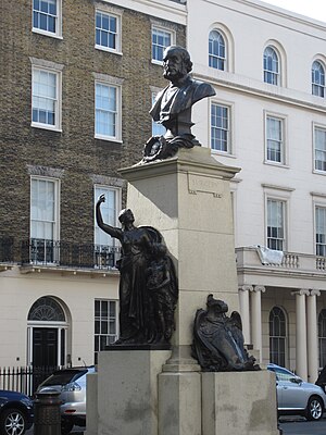
John F. Kennedy Memorial, London
Memorial in London, United Kingdom
Distance: Approx. 133 meters
Latitude and longitude: 51.52389,-0.144622
A 1965 memorial bust of John F. Kennedy by Jacques Lipchitz stands in the lobby of International Students House on Great Portland Street in London, England, and is visible from the outside through the glass doors. It was moved there in April 2019 from its original location on the Marylebone Road, to the west of Great Portland Street underground station, after it was vandalised in 2017.
Joseph Lister Memorial
Memorial by Joseph Lister in London
Distance: Approx. 94 meters
Latitude and longitude: 51.52248,-0.14596
The Joseph Lister Memorial is a memorial to Joseph Lister, 1st Baron Lister by the sculptor Thomas Brock, situated in Portland Place in Marylebone, London. The memorial is positioned in the centre of the road opposite numbers 71 to 81 and is Grade II listed. It is close to Lister's home at 12 Park Crescent.

40 Devonshire Street
Distance: Approx. 191 meters
Latitude and longitude: 51.5217,-0.1473
40 Devonshire Street is a grade II listed town house in Devonshire Street, in the City of Westminster, London. The house was built around 1910 in red brick with stone dressings in the arts and crafts Georgian revival style on a tall stone plinth. It was part of an attempt by the Portland Estate to revive the residential character of the area which they felt had become too professional.

Statue of the Duke of Kent
Statue in London, England
Distance: Approx. 33 meters
Latitude and longitude: 51.52301,-0.14619
The statue of the Duke of Kent is a sculpture located in Park Crescent, just south of Regent's Park and at the northern end of Portland Place in Central London. It is on land owned by the Crown Estate in the City of Westminster and was designed by the Irish artist Sebastian Gahagan. It commemorates Prince Edward, Duke of Kent and Strathearn, the fourth son of George III and brother of George IV (who was on the throne when the statue was erected) and William IV, as well as the father of the future Queen Victoria.
Weather in this IP's area
moderate rain
14 Celsius
14 Celsius
13 Celsius
15 Celsius
995 hPa
90 %
995 hPa
991 hPa
9000 meters
4.12 m/s
110 degree
75 %
07:11:27
18:24:54