102.163.40.151 - IP Lookup: Free IP Address Lookup, Postal Code Lookup, IP Location Lookup, IP ASN, Public IP
Country:
 Mauritius
Region:
City:
Location:
Time Zone:
Postal Code:
ISP:
ASN:
language:
User-Agent:
Proxy IP:
Blacklist:
IP information under different IP Channel
ip-api
Country
Region
City
ASN
Time Zone
ISP
Blacklist
Proxy
Latitude
Longitude
Postal
Route
db-ip
Country
Region
City
ASN
Time Zone
ISP
Blacklist
Proxy
Latitude
Longitude
Postal
Route
IPinfo
Country
Region
City
ASN
Time Zone
ISP
Blacklist
Proxy
Latitude
Longitude
Postal
Route
IP2Location
102.163.40.151Country
muRegion
pamplemousses
City
terre rouge
Time Zone
Indian/Mauritius
ISP
Language
User-Agent
Latitude
Longitude
Postal
ipdata
Country
Region
City
ASN
Time Zone
ISP
Blacklist
Proxy
Latitude
Longitude
Postal
Route
Popular places and events near this IP address

Jummah Mosque (Mauritius)
Mosque in Port Louis, Mauritius
Distance: Approx. 4277 meters
Latitude and longitude: -20.15986111,57.50486111
The Jummah Mosque (Arabic: مسجد جمعة) formerly "Mosque of the Arabs", is a mosque in Port Louis, Mauritius dating from the 1850s. The building combines Indian, Creole and Islamic architecture. The Jummah Mosque houses the remains of Jamal Shah (a pir from Kutch, India) in a marble tomb next to the mosque.

Aapravasi Ghat
Building complex in Port Louis, Mauritius
Distance: Approx. 4251 meters
Latitude and longitude: -20.158611,57.503056
Aapravasi Ghat (“The Immigration Depot”) is a building complex located in Port Louis, Mauritius, the first British colony to receive indentured, or contracted, labour workforce from many countries. From 1849 to 1923, half a million Indian indentured labourers passed through the Immigration Depot, to be transported to plantations throughout the British Empire. The large-scale migration of the labourers left an indelible mark on the societies of many former British colonies, with Indians constituting a substantial proportion of their national populations.

Rivière du Tombeau
River in Mauritius
Distance: Approx. 3016 meters
Latitude and longitude: -20.1,57.51666667
Rivière du Tombeau is a river in northwestern Mauritius. Its source is on the slopes of Pieter Both Mountain, from where it flows north and then west for a total of 16 kilometres, reaching the Indian Ocean at Baie-du-Tombeau, north of the capital of Port Louis.
Baie du Tombeau
Village in Pamplemousses District, Mauritius
Distance: Approx. 2310 meters
Latitude and longitude: -20.113831,57.506576
Baie du Tombeau is a village in Mauritius located in the Pamplemousses District, situated near the Rivière du Tombeau. The village is administered by the Baie du Tombeau Village Council under the aegis of the Pamplemousses District Council. According to the census by Statistics Mauritius in 2011, the population was at 14,687.
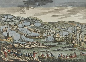
Invasion of Isle de France
1810 British invasion of Mauritius during the Napoleonic Wars
Distance: Approx. 3057 meters
Latitude and longitude: -20.15,57.51
The invasion of Isle de France was a complicated but successful British amphibious operation in the Indian Ocean, launched in November 1810 during the Napoleonic Wars. During the operation, a substantial military force was landed by the Royal Navy at Grand Baie, on the French colony of Isle de France (now Mauritius). Marching inland against weak French opposition, the British force was able to overwhelm the defenders in a series of minor engagements, culminating in the capture of the island's capital Port Napoleon and the surrender of Charles Decaen, the French governor.

Sainte-Croix, Mauritius
Distance: Approx. 2661 meters
Latitude and longitude: -20.15,57.525
Sainte-Croix is a suburb of the capital city, Port Louis, in Mauritius, an independent island in the Indian Ocean. It is most famous for its association with the Roman Catholic beatus Jacques-Désiré Laval, who worked in Sainte-Croix as a missionary from 1841 until his death in 1864. He is now buried at the Church of Sainte-Croix, and is thus a place of pilgrimage for Catholics in Mauritius.
Le Hochet
Village in Pamplemousses District, Mauritius
Distance: Approx. 1049 meters
Latitude and longitude: -20.135,57.52111111
Le Hochet is a village located in the Pamplemousses District of Mauritius. According to the 2011 census, the population was 15,034.

Droopnath Ramphul State College
Public school in Calebasses, Zone , Mauritius
Distance: Approx. 4260 meters
Latitude and longitude: -20.113959,57.563052
Droopnath Ramphul State College (DRSC) is an academy based in Calebasses, Pamplemouses, Mauritius admitting both boys and girls who performed well in the National Certificate of Education (NCE). Students are prepared for the School Certificate (SC) and the Higher School Certificate (HSC). The school derives its name from an eminent Judge Droopnath Ramphul.
St. François Xavier Stadium
Distance: Approx. 3255 meters
Latitude and longitude: -20.15388889,57.51472222
St. François Xavier Stadium is a multi-use stadium in Port Louis, Port Louis District, Mauritius. It is currently used mostly for staging football matches and is the home stadium of AS Port-Louis 2000.
1968 Mauritian riots
Christian–Muslim violent clashes in Port Louis
Distance: Approx. 3929 meters
Latitude and longitude: -20.16027778,57.515
The 1968 Mauritian riots or Bagarre raciale Plaine Verte refers to a number of violent clashes that occurred in the Port Louis neighbourhoods of Cité Martial, Bell Village, Roche Bois, St. Croix, Cité Martial and Plaine Verte as well as in the village of Madame Azor near Goodlands in Mauritius over a period of ten days, six weeks before the country's declaration of independence on 12 March 1968. The riot manifested as an open communal conflict between Creoles and Indo-Mauritian Muslims, and had its roots in gang rivalry, communal tensions caused by politicians, and uncertainties about the country's future given the imminence of independence from Britain.
1999 Mauritian riots
Riots and protests following a death in police custody
Distance: Approx. 2704 meters
Latitude and longitude: -20.14694444,57.51111111
The 1999 Mauritian riots were national-scale rioting and protests in Mauritius following the death of the popular "seggae" musician Joseph Réginald Topize, better known by his stage name "Kaya", in police custody. The rioting lasted for four days from 21 to 25 February 1999. Four civilians and one police officer were killed in the riots with hundreds of people suffering injuries.
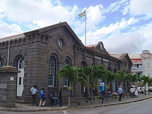
Mauritius Postal Museum
Postal Museum
Distance: Approx. 4458 meters
Latitude and longitude: -20.15996,57.50163
The Mauritius Postal Museum is the Postal museum in Port Louis, the capital city of Mauritius.
Weather in this IP's area
light rain
30 Celsius
37 Celsius
30 Celsius
30 Celsius
1011 hPa
79 %
1011 hPa
1007 hPa
10000 meters
5.94 m/s
5.81 m/s
64 degree
4 %