102.132.126.224 - IP Lookup: Free IP Address Lookup, Postal Code Lookup, IP Location Lookup, IP ASN, Public IP
Country:
 Democratic Republic of the Congo
Region:
City:
Location:
Time Zone:
Postal Code:
ISP:
ASN:
language:
User-Agent:
Proxy IP:
Blacklist:
IP information under different IP Channel
ip-api
Country
Region
City
ASN
Time Zone
ISP
Blacklist
Proxy
Latitude
Longitude
Postal
Route
db-ip
Country
Region
City
ASN
Time Zone
ISP
Blacklist
Proxy
Latitude
Longitude
Postal
Route
IPinfo
Country
Region
City
ASN
Time Zone
ISP
Blacklist
Proxy
Latitude
Longitude
Postal
Route
IP2Location
102.132.126.224Country
cdRegion
tshopo
City
kisangani
Time Zone
Africa/Lubumbashi
ISP
Language
User-Agent
Latitude
Longitude
Postal
ipdata
Country
Region
City
ASN
Time Zone
ISP
Blacklist
Proxy
Latitude
Longitude
Postal
Route
Popular places and events near this IP address
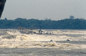
Boyoma Falls
Series of waterfalls on the Congo River in Orientale Province, Democratic Republic of the Congo
Distance: Approx. 2936 meters
Latitude and longitude: 0.49111111,25.20638889
Boyoma Falls (Swahili: Maporomoko ya Maji ya Boyoma, French: chutes de Boyoma, Dutch: Boyomawatervallen), formerly known as Stanley Falls (French: Chutes Stanley; Dutch: Stanleywatervallen), is a series of seven cataracts, each no more than 5 m (16 ft) high, extending over more than 100 km (62 mi) along a curve of the Lualaba River between the river port towns of Ubundu and Kisangani (also known as Boyoma) in the Orientale Province of the Democratic Republic of the Congo.: Vol.Two, 175 The seven cataracts have a total drop of 61 m (200 ft). They form the largest waterfall by volume of annual flow rate in the world, exceeding both the Niagara Falls and the Iguazu Falls. The two major cataracts are the first below Ubundu, forming a narrow and crooked stream that is hardly accessible, and the last that can be seen and visited from Kisangani.

Kisangani
City in the northeastern DR Congo
Distance: Approx. 4 meters
Latitude and longitude: 0.51666667,25.2
Kisangani (), formerly Stanleyville (Dutch: Stanleystad), is the capital of Tshopo Province, located on the Congo River in the eastern part of the central Congo Basin in the Democratic Republic of the Congo. It is the country's fifth-most populous urban area, with an estimated population of 1,602,144 as of 2016, and the largest of the cities in the tropical woodlands of the Congo. Geographically, Kisangani is flanked by Banalia Territory to the north, Bafwasende to the east, Ubundu Territory to the south, and is bordered by both Opala and Isangi Territories to the west.

Roman Catholic Archdiocese of Kisangani
Roman Catholic archdiocese in the Democratic Republic of the Congo
Distance: Approx. 1688 meters
Latitude and longitude: 0.5096,25.1866
The Roman Catholic Archdiocese of Kisangani (Latin: Kisanganien(sis)) is the Metropolitan See for the ecclesiastical province of Kisangani in the Democratic Republic of the Congo.

University of Kisangani
Public university in Kisangani, DRC
Distance: Approx. 2669 meters
Latitude and longitude: 0.5138,25.1762
The University of Kisangani (UNIKIS) is located in the city of Kisangani in the Democratic Republic of the Congo. It was founded in 1963 by Protestant missionaries as the Free University of the Congo (French: Université libre du Congo, ULC); it was transformed into part of the National University of Zaire in 1971, and in 1981 was separated from that National University, along with the University of Kinshasa and the University of Lubumbashi, assuming its present identity as the University of Kisangani. Its president is Professor Dr.

Haut-Congo Province
Former province in Republic of the Congo
Distance: Approx. 4 meters
Latitude and longitude: 0.51666667,25.2
Haut-Congo Province was a province of the Republic of the Congo (Léopoldville), now the Democratic Republic of the Congo. It was formed in April 1962 from part of the Orientale Province. In 1966 it was merged back into the reconstituted Orientale Province.

Stade Lumumba
Distance: Approx. 1577 meters
Latitude and longitude: 0.521216,25.186576
Stade Lumumba is a stadium located in Kisangani, Democratic Republic of the Congo. It has a capacity of 10,000 spectators for football matches. It serves as the home of AS Nika, TS Malekesa and AS Makiso of the Linafoot.

Tshopo
Province of the Democratic Republic of the Congo
Distance: Approx. 4 meters
Latitude and longitude: 0.51666667,25.2
Tshopo is one of the 21 provinces of the Democratic Republic of the Congo created in the 2015 repartitioning. It is situated in the north central part of the country on the Tshopo River, for which it is named. Tshopo, Bas-Uele, Haut-Uele, and Ituri provinces are the result of the dismemberment of the former Orientale province.

Simisini Air Base
Military airport of Kisangani, Democratic Republic of the Congo
Distance: Approx. 4948 meters
Latitude and longitude: 0.51722222,25.15555556
Kisangani Simisini Air Base (ICAO: FZIA) is a military airport in the city of Kisangani, capital of the Tshopo Province of the Democratic Republic of the Congo. Located in the western portion of Kisangani, 1 kilometre (0.6 mi) north of the Congo River, most of its traffic has moved to Bangoka International Airport. The airport is now a military airfield, though it also serves humanitarian flights and some private operations.
Our Lady of the Rosary Cathedral, Kisangani
Church in Kisangani, Democratic Republic of the Congo
Distance: Approx. 1709 meters
Latitude and longitude: 0.50978,25.1863
The Our Lady of the Rosary Cathedral (French: Cathédrale Notre-Dame du Rosaire) is a religious building belonging to the Catholic Church and is located in the town of Kisangani (formerly Stanleyville) in the province of Tshopo (formerly Eastern Province) in the African country of the Democratic Republic of Congo.

Stanleyville District
District in Orientale, Democratic Republic of the Congo
Distance: Approx. 4 meters
Latitude and longitude: 0.516667,25.2
Stanleyville District (French: District de Stanleyville, Dutch: District Stanleystad) was a district of the Belgian Congo and Democratic Republic of the Congo. It went through various changes in extent. Between 1933 and 1963 it had roughly the same extent as the current Tshopo province.

Stanley Falls District
District in Belgian Congo
Distance: Approx. 4 meters
Latitude and longitude: 0.516667,25.2
Stanley Falls District (French: District des Stanley Falls, Dutch: District Stanley Falls) was a district of the Congo Free State. It covered most of the eastern part of the colony along the Congo River south from Stanleyville (present-day Kisangani).
Marist University of the Congo
Distance: Approx. 271 meters
Latitude and longitude: 0.518863,25.201116
The Marist University of the Congo (UMC) is a private university in the Democratic Republic of the Congo, located in Kisangani, Tshopo Province.
Weather in this IP's area
overcast clouds
38 Celsius
38 Celsius
38 Celsius
38 Celsius
1000 hPa
25 %
1000 hPa
957 hPa
10000 meters
0.79 m/s
1.6 m/s
124 degree
98 %