102.128.137.161 - IP Lookup: Free IP Address Lookup, Postal Code Lookup, IP Location Lookup, IP ASN, Public IP
Country:
 South Africa
Region:
City:
Location:
Time Zone:
Postal Code:
ISP:
ASN:
language:
User-Agent:
Proxy IP:
Blacklist:
IP information under different IP Channel
ip-api
Country
Region
City
ASN
Time Zone
ISP
Blacklist
Proxy
Latitude
Longitude
Postal
Route
db-ip
Country
Region
City
ASN
Time Zone
ISP
Blacklist
Proxy
Latitude
Longitude
Postal
Route
IPinfo
Country
Region
City
ASN
Time Zone
ISP
Blacklist
Proxy
Latitude
Longitude
Postal
Route
IP2Location
102.128.137.161Country
zaRegion
western cape
City
rosebank
Time Zone
Africa/Johannesburg
ISP
Language
User-Agent
Latitude
Longitude
Postal
ipdata
Country
Region
City
ASN
Time Zone
ISP
Blacklist
Proxy
Latitude
Longitude
Postal
Route
Popular places and events near this IP address

Rondebosch
Place in Western Cape, South Africa
Distance: Approx. 928 meters
Latitude and longitude: -33.96333333,18.47638889
Rondebosch is one of the Southern Suburbs of Cape Town, South Africa. It is primarily a residential suburb, with shopping and business districts as well as the main campus of the University of Cape Town.

South African College of Music
Department of the Faculty of Humanities at the University of Cape Town
Distance: Approx. 410 meters
Latitude and longitude: -33.95638889,18.47
The South African College of Music, abbreviated as SACM, is a department of the Faculty of Humanities at the University of Cape Town. It is located on the university's Lower Campus in Rondebosch, Cape Town.

Rustenburg School for Girls
School in Cape Town, Western Cape, South Africa
Distance: Approx. 461 meters
Latitude and longitude: -33.95668889,18.47885556
Rustenburg Girls' High School and Rustenburg Girls' Junior School are two separate semi private schools with a shared history, originating in the suburb of Rondebosch in Cape Town, South Africa. Rustenburg was founded in 1894 and divided into separate junior and high schools in 1932.
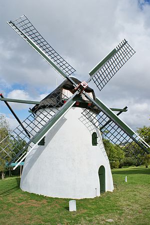
Mostert's Mill
Historic windmill in Cape Town, South Africa
Distance: Approx. 817 meters
Latitude and longitude: -33.95222222,18.46611111
Mostert's Mill (Afrikaans: Mostert se Meul) is a historic windmill in Mowbray, Cape Town, South Africa. It was built in 1796 and is the oldest surviving complete windmill in South Africa. It was almost completely destroyed by a wildfire on 18 April 2021 but was fully restored by April 2024 and is once more operational and used to grind wheat into whole meal, using the power of the wind.

Mowbray, Cape Town
Place in Western Cape, South Africa
Distance: Approx. 1027 meters
Latitude and longitude: -33.94611111,18.47611111
Mowbray is one of the Southern Suburbs of Cape Town, South Africa and lies on the slopes of Devil's Peak. Mowbray is at a junction of several major Cape Town highways and has an important multi-modal public transport interchange at Mowbray railway station. Its original name was Driekoppen ("Three heads" in Dutch).

Rosebank, Cape Town
Place in Western Cape, South Africa
Distance: Approx. 40 meters
Latitude and longitude: -33.95555556,18.47416667
Rosebank is one of the Southern Suburbs of Cape Town, South Africa, located between the suburbs of Mowbray and Rondebosch.
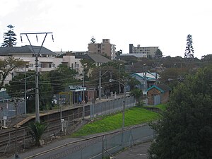
Rosebank railway station
Metrorail station on the Southern Line in Rosebank, Cape Town
Distance: Approx. 116 meters
Latitude and longitude: -33.9547,18.4731
Rosebank railway station is a Metrorail station on the Southern Line in Rosebank, a suburb of Cape Town. It is located between Main Road and Liesbeek Parkway; on the west side it is accessible from Ryan Road and Hope Road, while on the east side it is accessible from Lower Nursery Road. Rosebank is the closest railway station to the main campus of the University of Cape Town, being located only 300 metres (1,000 ft) from the university's Jammie Shuttle bus stop at Tugwell Hall residence.

Rondebosch Boys' Preparatory School
Boys' state school in South Africa
Distance: Approx. 1032 meters
Latitude and longitude: -33.96444444,18.475
Rondebosch Boys' Preparatory School is a state primary school in Rondebosch, a suburb of Cape Town, South Africa. It was detached from Rondebosch Boys' High School and established as a separate school in 1929.
Mowbray railway station
Metrorail station on the Southern Line
Distance: Approx. 950 meters
Latitude and longitude: -33.94666667,18.47388889
Mowbray railway station is a Metrorail station on the Southern Line, serving the suburb of Mowbray in Cape Town. The station has three tracks, served by a side platform and an island platform; the station building is at ground level on the western side of the tracks. Adjacent to the station is a major bus station of the Golden Arrow Bus Services and a large minibus taxi rank; Mowbray is the western end of the Klipfontein Road transport corridor to the Cape Flats.
Rondebosch railway station
Metrorail station on the Southern Line
Distance: Approx. 797 meters
Latitude and longitude: -33.96222222,18.4725
Rondebosch railway station is a Metrorail station on the Southern Line, serving the suburb of Rondebosch in Cape Town. The station has two side platforms and two tracks; the station building is at ground level on the eastern side of the tracks. The station is also served by Golden Arrow Bus Services.

Rondebosch Common
Conservation area in Cape Town
Distance: Approx. 844 meters
Latitude and longitude: -33.95555556,18.48333333
Rondebosch Common is an open common of about 40 hectares (100 acres) in Rondebosch, Cape Town in South Africa. A common is defined as "a piece of open land for public use, esp. in a village or town".

Rondebosch Fountain
Historic site in Cape Town, South Africa
Distance: Approx. 792 meters
Latitude and longitude: -33.96144444,18.47008333
Rondebosch Fountain is an ornamental Victorian drinking trough for horses, standing on a traffic island on the intersection between Belmont Road and Main Road in the centre of Rondebosch in Cape Town, South Africa. It was declared a National Monument on 10 April 1964. Originally known as the Moodie Fountain, the fountain was made of cast iron in 1891 and consisted of a circular drinking trough supported on horses' legs, with a central post topped with a hexagonal lantern.
Weather in this IP's area
light rain
18 Celsius
18 Celsius
17 Celsius
18 Celsius
1012 hPa
77 %
1012 hPa
1010 hPa
10000 meters
7.6 m/s
14.75 m/s
239 degree