Country:
 Mauritius
Region:
City:
Latitude and Longitude:
Time Zone:
Postal Code:
IP information under different IP Channel
ip-api
Country
Region
City
ASN
Time Zone
ISP
Blacklist
Proxy
Latitude
Longitude
Postal
Route
IPinfo
Country
Region
City
ASN
Time Zone
ISP
Blacklist
Proxy
Latitude
Longitude
Postal
Route
MaxMind
Country
Region
City
ASN
Time Zone
ISP
Blacklist
Proxy
Latitude
Longitude
Postal
Route
Luminati
Country
MURegion
fl
City
centredeflacq
ASN
Time Zone
Indian/Mauritius
ISP
MauritiusTelecom
Latitude
Longitude
Postal
db-ip
Country
Region
City
ASN
Time Zone
ISP
Blacklist
Proxy
Latitude
Longitude
Postal
Route
ipdata
Country
Region
City
ASN
Time Zone
ISP
Blacklist
Proxy
Latitude
Longitude
Postal
Route
Popular places and events near this IP address

Mauritius
Island country in the Indian Ocean
Distance: Approx. 2357 meters
Latitude and longitude: -20.2,57.5
Mauritius, officially the Republic of Mauritius, is an island country in the Indian Ocean, about 2,000 kilometres (1,100 nautical miles) off the southeastern coast of East Africa, east of Madagascar. It includes the main island (also called Mauritius), as well as Rodrigues, Agaléga, and St. Brandon (Cargados Carajos shoals).
Moka
Villages in Moka District, Mauritius
Distance: Approx. 2101 meters
Latitude and longitude: -20.219,57.496
Moka (Mauritian Creole pronunciation: [moka]) is a village in Mauritius located mainly in the Moka District. The western part of the village lies in the Plaines Wilhems District. Since 1967 it forms part of Constituency No.
Outer Islands of Mauritius
Distance: Approx. 2357 meters
Latitude and longitude: -20.2,57.5
The Outer Islands of Mauritius (French: Îles éparses de Maurice) is the first-level administrative divisions of the country and consists of the islands of Mauritius and several outlying islands. The Outer Islands of Mauritius are managed under the aegis of the Prime Minister of Mauritius through Prime Minister's Office by the Outer Islands Development Corporation which is the authority empowered under the law to manage the Outer Islands of Mauritius. The Prime Minister is also Minister for Rodrigues, Outer Islands and Territorial Integrity.
Le Bocage International School
Private international school in Moka, Mauritius
Distance: Approx. 1118 meters
Latitude and longitude: -20.215,57.505
Le Bocage International School (LBIS) is an English-medium, private international school offering educational services to boys and girls from the ages of 11–19. LBIS was founded in 1990 and is located at Mount Ory, Moka (Mauritius). LBIS is an IBO school that offers the International Baccalaureate Program for the Middle Years, form 1–5, and the Diploma years, form 6–7.
Saint Pierre, Mauritius
Distance: Approx. 192 meters
Latitude and longitude: -20.21666667,57.51666667
Saint Pierre is a village in the district of Moka in Mauritius. It is considered to be found in the heart of Mauritius.The climatic conditions is cold and ideal especially during summer with cold breeze. The village has significantly changed over the years with a new shopping centre, namely Kendra, gyms, driving more traffic to the village.

British Mauritius
British colony in Africa from 1810 to 1968
Distance: Approx. 2357 meters
Latitude and longitude: -20.2,57.5
Mauritius was a Crown colony off the southeast coast of Africa. Formerly part of the French colonial empire, British rule in Mauritius was established de facto with the invasion of Isle de France in November 1810, and de jure by the subsequent Treaty of Paris. British rule ended on 12 March 1968, when Mauritius became an independent country.

Dutch Mauritius
Former Dutch colony
Distance: Approx. 2357 meters
Latitude and longitude: -20.2,57.5
Mauritius was an official settlement of the Dutch East India Company on the island of Mauritius between 1638 and 1710, and used as a refreshing station for passing ships. It was already frequented by Dutch ships from 1598 onwards, but only settled in 1638, to prevent the French and the British from settling on the island.
Mauritius (1968–1992)
Monarchy of Mauritius with Elizabeth II as head of state
Distance: Approx. 2357 meters
Latitude and longitude: -20.2,57.5
Between independence in 1968 and becoming a republic in 1992, Mauritius was an independent sovereign state that shared its head of state with the United Kingdom and other states headed by Elizabeth II. In 1968, the United Kingdom's Mauritius Independence Act 1968 granted independence to the British Crown Colony of Mauritius. The British monarch, Elizabeth II, remained head of state as Queen of Mauritius, as well as being Queen of the United Kingdom and the other Commonwealth realms. The monarch's constitutional roles in Mauritius were mostly delegated to the Governor-General of Mauritius.
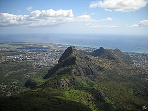
Moka Range
Mountain range in Mauritius
Distance: Approx. 1951 meters
Latitude and longitude: -20.2,57.525
The Moka Range is a mountain range in Mauritius. It contains two of Mauritius's three tallest peaks, Pieter Both and Le Pouce. It was formed from a basalt lava dome ten million years ago.
Best FM (Mauritius)
Radio station
Distance: Approx. 2188 meters
Latitude and longitude: -20.229811,57.501692
Best FM is a Hindi-language entertainment radio station in Mauritius that is owned and broadcast by the Mauritius Broadcasting Corporation. The radio started operating on the 5th of October 2010 and is entirely dedicated to Bollywood music and has as slogan "Aur Kya Chahiye?" (What else is neded?). The radio channel opened as its sister station Taal FM which has been rebranded to a regional radio station, broadcasting shows in 13 popular languages in Mauritius.
Lycée des Mascareignes
School
Distance: Approx. 1618 meters
Latitude and longitude: -20.2270879,57.524617
Lycée des Mascareignes is a private French international school in Saint Pierre, Moka, Mauritius. It serves senior high school classes (Seconde, Première, Terminale).
Mahatma Gandhi Institute (Mauritius)
Public school in Moka, Mauritius
Distance: Approx. 1868 meters
Latitude and longitude: -20.2272,57.5032
The Mahatma Gandhi Institute (commonly known as MGI), located in Moka on the island of Mauritius, is an educational institution focused of secondary, tertiary and pre-vocational education. It also promotes and facilitates research and preservation of cultural heritage and arts.
Weather in this IP's area
overcast clouds
20 Celsius
21 Celsius
20 Celsius
22 Celsius
1016 hPa
93 %
1016 hPa
975 hPa
10000 meters
1.94 m/s
2.42 m/s
86 degree
98 %
05:36:50
18:12:57