Country:
 Mauritius
Region:
City:
Latitude and Longitude:
Time Zone:
Postal Code:
IP information under different IP Channel
ip-api
Country
Region
City
ASN
Time Zone
ISP
Blacklist
Proxy
Latitude
Longitude
Postal
Route
IPinfo
Country
Region
City
ASN
Time Zone
ISP
Blacklist
Proxy
Latitude
Longitude
Postal
Route
MaxMind
Country
Region
City
ASN
Time Zone
ISP
Blacklist
Proxy
Latitude
Longitude
Postal
Route
Luminati
Country
MURegion
pw
City
vacoas
ASN
Time Zone
Indian/Mauritius
ISP
MauritiusTelecom
Latitude
Longitude
Postal
db-ip
Country
Region
City
ASN
Time Zone
ISP
Blacklist
Proxy
Latitude
Longitude
Postal
Route
ipdata
Country
Region
City
ASN
Time Zone
ISP
Blacklist
Proxy
Latitude
Longitude
Postal
Route
Popular places and events near this IP address
College Sainte-Marie (Mauritius)
School in Quatre Bornes, Mauritius
Distance: Approx. 3784 meters
Latitude and longitude: -20.281532,57.447528
College Sainte-Marie is a private secondary school based in Quatre Bornes, Mauritius. Students are prepared for the School Certificate and the Higher School Certificate. The school began enrolling students in September 2004.
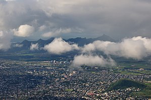
Quatre Bornes
Town in Plaines Wilhems, Mauritius
Distance: Approx. 4182 meters
Latitude and longitude: -20.26535833,57.47905278
Quatre Bornes (Mauritian Creole pronunciation: [kat(ʁe) boːn]), also known as La Ville des Fleurs (The City of Flowers), is a town in Mauritius, located mainly in the Plaines Wilhems District. Its western part lies in the Rivière Noire District. The town is administered by the Municipal Council of Quatre Bornes.

Plaines Wilhems District
District in Mauritius
Distance: Approx. 846 meters
Latitude and longitude: -20.3,57.48333333
Plaines Wilhems (Mauritian Creole pronunciation: [plɛn wilɛmz]) is a district of Mauritius. It is the most populous district, with an estimated population of 366,506 at the end of 2018. The district is mainly urban; it consists of four towns, the village of Midlands and part of two other villages.

Vacoas-Phoenix
Town in Plaines Wilhems, Mauritius
Distance: Approx. 335 meters
Latitude and longitude: -20.30004722,57.47450833
Vacoas-Phoenix (Mauritian Creole pronunciation: [vakwa feniks]) also known as French: Villes Jumelles (Twin Cities), is a town in Mauritius, located in the Plaines Wilhems District, the eastern part also lies in the Moka District. The town is administered by the Municipal Council of Vacoas-Phoenix. The town lies between Quatre Bornes and Curepipe.

Trou aux Cerfs
Distance: Approx. 3337 meters
Latitude and longitude: -20.315,57.505
Trou aux Cerfs (also known as Murr's Volcano) is a dormant volcano with a well-defined cone and crater. It is 605 m (1,985 ft) high and located in Curepipe, Mauritius. The crater has been alternately described as 300 and 350 meters in diameter, and is 80 meters deep.

Collège du Saint-Esprit
College in Quatre Bornes, Mauritius
Distance: Approx. 4120 meters
Latitude and longitude: -20.266173,57.47013
The Collège du Saint Esprit is a private catholic secondary school in Mauritius. It is one of the most prestigious and competitive secondary education institutions in the country.
Sir Abdool Raman Osman State College
Academy, national college in Mauritius
Distance: Approx. 3093 meters
Latitude and longitude: -20.282124,57.495596
Sir Abdool Raman Osman State College, abbreviated as SARO SC or simply SARO, is a public secondary school for boys and girls in Phoenix, Mauritius. It was found in 1996 as the Royal College of Phoenix and was renamed in late 1996 after Sir Abdool Raman Osman, the first Governor-General of Mauritius. The school became a National College in 2007.
Henrietta, Mauritius
Distance: Approx. 3530 meters
Latitude and longitude: -20.33333333,57.46666667
Henrietta is found in the town of Vacoas-Phoenix, Mauritius. It is said to be the 'finishing part' of Vacoas as beyond it there is only forest.
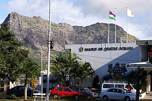
Municipal Council of Quatre Bornes
Distance: Approx. 4182 meters
Latitude and longitude: -20.265357,57.479053
The Municipal Council of Quatre Bornes (French: Conseil Municipal de Quatre Bornes) is the local authority responsible for the administration of the town of Quatre Bornes, Plaines Wilhems District, Mauritius. In 2015, three former councilors were convicted of conflict of interest.

Municipal Council of Vacoas-Phoenix
Distance: Approx. 335 meters
Latitude and longitude: -20.300047,57.474509
The Municipal Council of Vacoas-Phoenix (French: Conseil Municipal de Vacoas-Phoenix) also known as Municipality is the local authority responsible for the administration of the town of Vacoas-Phoenix, Plaines Wilhems District, Mauritius. The Mayor is Praveen Kumar Ramburn and the Deputy Mayor Mike Manfred Roy Mungur.

Rempart Mountain
Mountain of Rivière Noire District, Mauritius
Distance: Approx. 4724 meters
Latitude and longitude: -20.30305556,57.43055556
Rempart Mountain is a mountain near Tamarin in the Rivière Noire District, western Mauritius. Rempart Mountain is the fourth-highest peak in Mauritius, after Le Pouce. It is notable for its prominence, which is due to its three distinct peaks.
Quatre Bornes State Secondary School
School in Quatre Bornes, Mauritius
Distance: Approx. 4179 meters
Latitude and longitude: -20.2653,57.4776
Quatre Bornes State Secondary School (QBSSS) is a government-operated secondary school in Quatre Bornes, Mauritius. The school opened on the grounds of the Sodnac SSS in 2005. It moved to Belle Rose SSS and then to the former Strattford College facility in 2009.
Weather in this IP's area
broken clouds
23 Celsius
23 Celsius
21 Celsius
23 Celsius
1023 hPa
76 %
1023 hPa
977 hPa
10000 meters
0.45 m/s
2.68 m/s
267 degree
54 %
06:12:39
18:03:10