101.50.43.125 - IP Lookup: Free IP Address Lookup, Postal Code Lookup, IP Location Lookup, IP ASN, Public IP
Country:
Region:
City:
Location:
Time Zone:
Postal Code:
IP information under different IP Channel
ip-api
Country
Region
City
ASN
Time Zone
ISP
Blacklist
Proxy
Latitude
Longitude
Postal
Route
Luminati
Country
Region
34
City
hiroshima
ASN
Time Zone
Asia/Tokyo
ISP
Chupicom Inc.
Latitude
Longitude
Postal
IPinfo
Country
Region
City
ASN
Time Zone
ISP
Blacklist
Proxy
Latitude
Longitude
Postal
Route
IP2Location
101.50.43.125Country
Region
hiroshima
City
nuno
Time Zone
Asia/Tokyo
ISP
Language
User-Agent
Latitude
Longitude
Postal
db-ip
Country
Region
City
ASN
Time Zone
ISP
Blacklist
Proxy
Latitude
Longitude
Postal
Route
ipdata
Country
Region
City
ASN
Time Zone
ISP
Blacklist
Proxy
Latitude
Longitude
Postal
Route
Popular places and events near this IP address

Hiroshima City Asa Zoological Park
Zoo in Asakita-ku, Hiroshima
Distance: Approx. 5431 meters
Latitude and longitude: 34.497856,132.44069
Hiroshima City Asa Zoological Park (広島市安佐動物公園, Hiroshima-shi Asa Dōbutsukōen) is a zoo in Hiroshima, Japan.

Aki-Kameyama Station (1936–2003)
Distance: Approx. 5623 meters
Latitude and longitude: 34.52205556,132.45977778
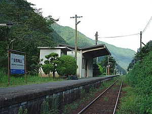
Aki-Kameyama Station (安芸亀山駅, Aki-Kameyama Eki) is a closed railway station on the Kabe Line in Katsugi, Kabe-chō, Asakita-ku, Hiroshima, Hiroshima Prefecture, Japan, formerly operated by West Japan Railway Company (JR West). It closed on 1 December 2003 when operation of the line was discontinued/suspended between Kabe Station and Sandankyō Station.

Kegi Station
Former railway station in Hiroshima Prefecture, Japan
Distance: Approx. 3367 meters
Latitude and longitude: 34.53166667,132.43666667
Kegi Station (毛木駅, Kegi Eki) is a former JR West Kabe Line station located in Iimuro, Asa-machi, Asakita-ku, Hiroshima, Hiroshima Prefecture, Japan. The station is located near Jinshin Bridge, and was going to be named after the bridge. However, when it came time to name the station, the residents in the area wanted it named Kegi, after the area in which it was located.
Tomo Station
Railway station in Hiroshima, Japan
Distance: Approx. 7288 meters
Latitude and longitude: 34.4699,132.4198
Tomo Station is a HRT station on Astram Line, located in 8669-4, Tomo, Numata-cho, Asaminami-ku, Hiroshima.

Aki-Imuro Station
Former railway station in Hiroshima Prefecture, Japan
Distance: Approx. 2993 meters
Latitude and longitude: 34.544525,132.42966111
Aki-Imuro Station (安芸飯室駅, Aki-Imuro-eki) is a former JR West Kabe Line station located in Asakita-ku, Hiroshima, Hiroshima Prefecture, Japan. It closed on December 1, 2003, when operation of the line was discontinued/suspended between Kabe Station and Sandankyō Station.

Nuno Station
Former railway station in Hiroshima Prefecture, Japan
Distance: Approx. 751 meters
Latitude and longitude: 34.53411111,132.40813333
Nuno Station (布駅, Nuno-eki) is a former JR West Kabe Line station located in Asakita-ku, Hiroshima, Hiroshima Prefecture, Japan. It closed on December 1, 2003, when operation of the line was discontinued/suspended between Kabe Station and Sandankyō Station.

Ogauchi Station
Former railway station in Hiroshima Prefecture, Japan
Distance: Approx. 1584 meters
Latitude and longitude: 34.5475,132.40105278
Ogauchi Station (小河内駅, Ogauchi-eki) is a former JR West Kabe Line station located in Asakita-ku, Hiroshima, Hiroshima Prefecture, Japan. It closed on December 1, 2003 when operation of the line was discontinued/suspended between Kabe Station and Sandankyō Station.

Yasuno Station
Former railway station in Hiroshima Prefecture, Japan
Distance: Approx. 2960 meters
Latitude and longitude: 34.55430278,132.38021111
Yasuno Station (安野駅, Yasuno-eki) is a former JR West Kabe Line station located in Kake, Yamagata District, Hiroshima Prefecture, Japan. It closed on December 1, 2003, when operation of the line was discontinued/suspended between Kabe Station and Sandankyō Station.
Minochi Station
Former railway station in Hiroshima Prefecture, Japan
Distance: Approx. 5432 meters
Latitude and longitude: 34.55223056,132.34539722
Minochi Station (水内駅, Minochi-eki) is a former JR West Kabe Line station located in Yuki, Saeki District, Hiroshima Prefecture, Japan. It closed on December 1, 2003, when operation of the line was discontinued/suspended between Kabe Station and Sandankyō Station.

Tsubono Station
Former railway station in Hiroshima Prefecture, Japan
Distance: Approx. 6279 meters
Latitude and longitude: 34.55724167,132.338
Tsubono Station (坪野駅, Tsubono-eki) is a former JR West Kabe Line station located in Yuki, Saeki District, Hiroshima Prefecture, Japan. It closed on December 1, 2003, when operation of the line was discontinued/suspended between Kabe Station and Sandankyō Station.
Aratani-ike Dam
Dam in Hiroshima Prefecture, Japan
Distance: Approx. 5608 meters
Latitude and longitude: 34.49333333,132.43722222
Aratani-ike Dam (Japanese: 荒谷池) is an earthfill dam located in Hiroshima Prefecture in Japan. The dam is used for irrigation. The catchment area of the dam is 0.2 km2.
Uga Dam
Dam in Hiroshima Prefecture, Japan
Distance: Approx. 1364 meters
Latitude and longitude: 34.54027778,132.38777778
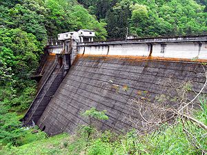
Uga Dam (Japanese: 宇賀ダム) is a gravity dam located in Hiroshima Prefecture in Japan. The dam is used for power production. The catchment area of the dam is 489.5 km2.
Weather in this IP's area
clear sky
1 Celsius
1 Celsius
1 Celsius
1 Celsius
1023 hPa
74 %
1023 hPa
988 hPa
10000 meters
1 m/s
1.22 m/s
282 degree
4 %

