Country:
 Egypt
EgyptRegion:
City:
Latitude and Longitude:
Time Zone:
Postal Code:
IP information under different IP Channel
ip-api
Country
Region
City
ASN
Time Zone
ISP
Blacklist
Proxy
Latitude
Longitude
Postal
Route
IPinfo
Country
Region
City
ASN
Time Zone
ISP
Blacklist
Proxy
Latitude
Longitude
Postal
Route
MaxMind
Country
Region
City
ASN
Time Zone
ISP
Blacklist
Proxy
Latitude
Longitude
Postal
Route
Luminati
Country
EGRegion
c
ASN
Time Zone
Africa/Cairo
ISP
HUAWEI CLOUDS
Latitude
Longitude
Postal
db-ip
Country
Region
City
ASN
Time Zone
ISP
Blacklist
Proxy
Latitude
Longitude
Postal
Route
ipdata
Country
Region
City
ASN
Time Zone
ISP
Blacklist
Proxy
Latitude
Longitude
Postal
Route
Popular places and events near this IP address

Cairo
Capital city of Egypt
Distance: Approx. 14 meters
Latitude and longitude: 30.04444444,31.23583333
Cairo ( KY-roh; Arabic: القاهرة, romanized: al-Qāhirah, Egyptian Arabic pronunciation: [el.qɑ(ː)ˈheɾɑ] ) is the capital of Egypt and the Cairo Governorate, and is the country's largest city, being home to more than 10 million people. It is also part of the largest urban agglomeration in Africa, the Arab world and the Middle East. The Greater Cairo metropolitan area is the 12th-largest in the world by population with over 22.1 million people.

Headquarters of the Arab League
Distance: Approx. 98 meters
Latitude and longitude: 30.04416667,31.23472222
The Headquarters of the Arab League is located in Tahrir Square and near the downtown business district of Cairo, Egypt. The headquarters building has views of the Nile River and Qasr al-Nil Bridge just to the west.

Dubara Palace
Palace in Cairo
Distance: Approx. 315 meters
Latitude and longitude: 30.04222222,31.23361111
The Dubara Palace is located at the Simon Bolivar square in the north part of the Garden City district in downtown Cairo, Egypt. It is used for an evangelical church school. It is known as Villa Casdagli or Kasr EL-Dobara Experimental Language School, too.

Khairy Pasha Palace
Neo-Mameluk building in Cairo, Egypt
Distance: Approx. 233 meters
Latitude and longitude: 30.04277778,31.23722222
Khairy Pasha Palace is a neo-Mameluk building and former palace of Khairy Pasha, located on 113 Qasr El Eyni Street, in Tahrir Square, Cairo. It served as the American University in Cairo's Tahrir Square campus (AUC Downtown) since 1920 until 2008 when the new campus was inaugurated in New Cairo (AUC New Cairo). The building in the photograph on the right was originally the Girls' School of the Greek Community of Cairo.

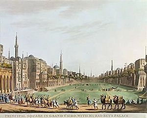
Tahrir Square
Town square in Downtown Cairo, Egypt
Distance: Approx. 14 meters
Latitude and longitude: 30.04444444,31.23583333
Tahrir Square (Arabic: ميدان التحرير, romanized: Maydān at-Taḥrīr, Egyptian Arabic pronunciation: [meˈdæːn ettæħˈɾiːɾ]; English: "Liberation Square"), also known as Martyr Square, is a public town square in downtown Cairo, Egypt. The square has been the location and focus for political demonstrations. The 2011 Egyptian revolution and the resignation of President Hosni Mubarak occurred at the Tahrir Square.

Institut d'Égypte
Distance: Approx. 250 meters
Latitude and longitude: 30.042164,31.235928
The Institut d'Égypte or Egyptian Scientific Institute is a learned society in Cairo specializing in Egyptology. It was established in 1798 by Napoleon Bonaparte to carry out research during his Egyptian campaign and is the oldest scientific institute in Egypt. The building in which it was housed was burnt down, with the loss of many documents, during the Arab Spring unrest of 2011.

The Mogamma
Building in Cairo, Egypt
Distance: Approx. 159 meters
Latitude and longitude: 30.04310539,31.23499444
Mogamma el Tahrir (Egyptians name it: مجمع التحرير and is translated as : Complex of Liberation ) is a government building in Cairo, Egypt. The Mogamma was the result of a series of master plans for Esamailiyya Square (now Tahrir Square), which used to be occupied by the British barracks. In 1945 when King Farouk ordered the demolition of the barracks upon the departure of British troops from the area, a series of urban planning proposals ensued.
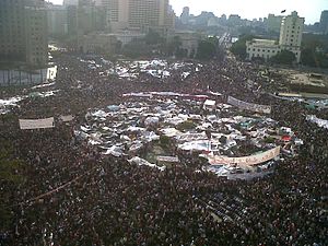
2011 Egyptian revolution
Political upheaval in Egypt
Distance: Approx. 15 meters
Latitude and longitude: 30.04444444,31.23555556
The 2011 Egyptian revolution, also known as the 25 January Revolution (Arabic: ثورة ٢٥ يناير, romanized: Thawrat khamsa wa-ʿišrūn yanāyir;), began on 25 January 2011 and spread across Egypt. The date was set by various youth groups to coincide with the annual Egyptian "Police holiday" as a statement against increasing police brutality during the last few years of Hosni Mubarak's presidency. It consisted of demonstrations, marches, occupations of plazas, non-violent civil resistance, acts of civil disobedience and strikes.

June 2013 Egyptian protests
Demonstrations against President Mohamed Morsi
Distance: Approx. 15 meters
Latitude and longitude: 30.04444444,31.23555556
The 30 June revolution occurred in Egypt on 30 June 2013, marking the one-year anniversary of Mohamed Morsi's inauguration as president. The events ended with the 2013 Egyptian coup d'état after mass protests across Egypt demanding the immediate resignation of the president. The rallies were partly a response to Tamarod, an ostensibly grassroots movement that launched a petition in April 2013, calling for Morsi and his government to step down.

Semiramis InterContinental Hotel
Complex located in Garden City, Cairo, Egypt
Distance: Approx. 343 meters
Latitude and longitude: 30.04301,31.23252
Semiramis InterContinental Hotel is a skyscraper and hotel complex located in Garden City, Cairo, Egypt. The 32-story building completed in 1987, and houses an InterContinental hotel. The modernist building replaced the historic Semiramis hotel, and contains 726 rooms and suites, restaurants, bars, a cafe, outdoor Nile view terraces, a Spa, a gym, ballrooms, conference and meeting rooms, a shopping arcade and a casino.
Siege of Cairo
1801 siege during the French Campaign in Egypt and Syria
Distance: Approx. 14 meters
Latitude and longitude: 30.04444444,31.23583333
The siege of Cairo, also known as the Cairo campaign, was a siege that took place during the French Revolutionary Wars, between French and British with Ottoman forces and was the penultimate action of the Egyptian Campaign. British commander John Hely-Hutchinson advanced to Cairo, where he arrived after a few skirmishes in mid June. Joined by a sizeable Ottoman force Hutchinson invested Cairo and on 27 June the surrounded 13,000-strong French garrison under General Augustin Daniel Belliard, out-manned and out-gunned then surrendered.

The GrEEK Campus
Technology and innovation park in Cairo, Egypt
Distance: Approx. 306 meters
Latitude and longitude: 30.04399,31.23884
The GrEEK Campus, also GEEK Campus, is a technology park in Cairo, Egypt. The campus provides workspaces for rent, for startups, as well as established local and multinational companies. Located in Downtown Cairo, The GrEEK Campus consists of five office buildings with a total space of 25,000 m2.
Weather in this IP's area
scattered clouds
26 Celsius
26 Celsius
26 Celsius
26 Celsius
1010 hPa
83 %
1010 hPa
1006 hPa
6000 meters
2.06 m/s
300 degree
40 %
06:36:04
19:09:38