Country:
 Chile
ChileRegion:
City:
Latitude and Longitude:
Time Zone:
Postal Code:
IP information under different IP Channel
ip-api
Country
Region
City
ASN
Time Zone
ISP
Blacklist
Proxy
Latitude
Longitude
Postal
Route
IPinfo
Country
Region
City
ASN
Time Zone
ISP
Blacklist
Proxy
Latitude
Longitude
Postal
Route
MaxMind
Country
Region
City
ASN
Time Zone
ISP
Blacklist
Proxy
Latitude
Longitude
Postal
Route
Luminati
Country
CLRegion
rm
City
santiago
ASN
Time Zone
America/Santiago
ISP
HUAWEI CLOUDS
Latitude
Longitude
Postal
db-ip
Country
Region
City
ASN
Time Zone
ISP
Blacklist
Proxy
Latitude
Longitude
Postal
Route
ipdata
Country
Region
City
ASN
Time Zone
ISP
Blacklist
Proxy
Latitude
Longitude
Postal
Route
Popular places and events near this IP address

Diego Portales University
University in Chile
Distance: Approx. 710 meters
Latitude and longitude: -33.44995,-70.66168
Diego Portales University (Spanish: Universidad Diego Portales, UDP) is one of the first private universities founded in Chile and is named after the Chilean statesman Diego Portales. UDP has campuses in the Barrio Universitario de Santiago and Huechuraba.

Alberto Hurtado University
Jesuit university in Santiago
Distance: Approx. 799 meters
Latitude and longitude: -33.44481667,-70.66204444
Alberto Hurtado University (Spanish: Universidad Alberto Hurtado – UAH) is a Jesuit university located in Santiago, Chile. Established in 1997, the university was created from the merger of three separate institutes: Instituto Latinoamericano de Doctrina y Estudios Sociales (ILADES), the Centro de Investigación, Desarrollo de la Educación (CIDE), and the Fundación Educacional Roberto Bellarmino. The university is named after a famous Chilean Jesuit Saint, Father Alberto Hurtado.

Captaincy General of Chile
1541–1818 territory of the Spanish Empire
Distance: Approx. 271 meters
Latitude and longitude: -33.45,-70.666667
The General Captaincy of Chile (Capitanía General de Chile [kapitaˈni.a xeneˈɾal de ˈtʃile]), Governorate of Chile, or Kingdom of Chile, was a territory of the Spanish Empire from 1541 to 1818 that was, initially, part of the Viceroyalty of Peru. It comprised most of modern-day Chile and southern parts of Argentina in the Patagonia region. Its capital was Santiago de Chile.
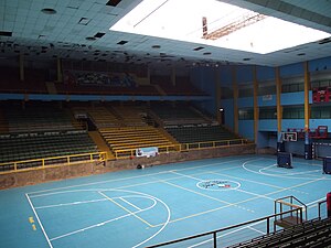
Víctor Jara Stadium
Distance: Approx. 548 meters
Latitude and longitude: -33.45077222,-70.67460556
Estadio Víctor Jara is an indoor multi-use sports complex located in the western part of Santiago, Chile, near the Estación Central and Alameda Avenue. It has a total capacity for an audience of 6,500 people. After the Chilean coup of 1973, it was used as a detention centre; about 3,000 people were killed there, including singer and songwriter Victor Jara.

Alameda (Santiago)
Avenue in Santiago, Chile
Distance: Approx. 128 meters
Latitude and longitude: -33.44861111,-70.67055556
Avenida Libertador General Bernardo O'Higgins (English: General Liberator Bernardo O'Higgins Avenue), popularly known as 'La Alameda' (meaning, a street bordered by poplar trees), is the main avenue of Santiago, Chile. It runs east-west in the centre of the greater urban area and is 7.77 km (4.83 mi) long, and it has up to 5 lanes in each direction. It was named after Chile's founding father Bernardo O'Higgins.

Andrés Bello National University
Private university in Chile
Distance: Approx. 354 meters
Latitude and longitude: -33.4514,-70.667
The Andrés Bello National University (Spanish: Universidad Andrés Bello or Universidad Nacional Andrés Bello; UNAB) is a Chilean private university founded in 1988. UNAB is ranked 56th among Latin American universities in 2022, and Andrés Bello University currently ranked 8th among Chilean universities according to the CSIC webometric.
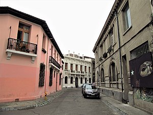
Barrio Concha y Toro
Distance: Approx. 471 meters
Latitude and longitude: -33.44557778,-70.66591667
Barrio Concha y Toro is a barrio in Santiago, Chile, with a medieval-like street plan influenced by the ideas of Camillo Sitte. The houses are built on the former site of the Díaz Gana Palace's park, which was divided into lots in 1915. The barrio's boundaries are defined by Brasil Avenue, Avenida Libertador General Bernardo O'Higgins, Cumming Avenue, Romero Street, Maturana Street and Erasmo Escala Street.
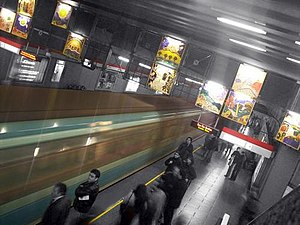
República metro station (Santiago)
Santiago metro station
Distance: Approx. 195 meters
Latitude and longitude: -33.44777778,-70.6675
República is an underground metro station on the Line 1 of the Santiago Metro, in Santiago, Chile. This station is named for República Avenue. The station was opened on 15 September 1975 as part of the inaugural section of the line between San Pablo and La Moneda.

Unión Latinoamericana metro station
Santiago metro station
Distance: Approx. 473 meters
Latitude and longitude: -33.44972222,-70.67416667
Unión Latinoamericana, also known as ULA, is an underground metro station on the Line 1 of the Santiago Metro, in Santiago, Chile. It is close to Víctor Jara Stadium. The station was opened on 15 September 1975 as part of the inaugural section of the line between San Pablo and La Moneda.

Venda Sexy
Former torture center in Santiago, Chile
Distance: Approx. 10 meters
Latitude and longitude: -33.44888889,-70.66916667
The Venda Sexy is an estate near Santiago, Chile that was used as a torture center by the DINA secret police during the military dictatorship of Augusto Pinochet.

Conjunto Virginia Opazo
National monument of Chile
Distance: Approx. 56 meters
Latitude and longitude: -33.4493,-70.6691
The Conjunto Virginia Opazo is an architectural ensemble designed by architect Luciano Kulczewski, which is located in the Barrio República, in downtown Santiago, Chile. It consists of 33 two-story terraced houses. The residential subdivision was inaugurated in 1944, and was declared as a National Monument of Chile on November 10, 1992, within the category of Zona Típica (Heritage District).

Museo de la Solidaridad Salvador Allende
Contemporary art museum in Santiago, Chile
Distance: Approx. 613 meters
Latitude and longitude: -33.45413,-70.66755
The Museum of Solidarity Salvador Allende (MSSA) (Spanish: Museo de la Solidaridad Salvador Allende) is a contemporary art museum located in Santiago, Chile, named after Salvador Allende, president of Chile between 1970 and 1973.
Weather in this IP's area
overcast clouds
10 Celsius
9 Celsius
8 Celsius
12 Celsius
1018 hPa
70 %
1018 hPa
954 hPa
10000 meters
0.79 m/s
1.06 m/s
129 degree
100 %
07:50:50
19:29:54