Country:
 Mexico
Region:
City:
Latitude and Longitude:
Time Zone:
Postal Code:
IP information under different IP Channel
ip-api
Country
Region
City
ASN
Time Zone
ISP
Blacklist
Proxy
Latitude
Longitude
Postal
Route
IPinfo
Country
Region
City
ASN
Time Zone
ISP
Blacklist
Proxy
Latitude
Longitude
Postal
Route
MaxMind
Country
Region
City
ASN
Time Zone
ISP
Blacklist
Proxy
Latitude
Longitude
Postal
Route
Luminati
Country
MXRegion
cmx
City
mexicocity
ASN
Time Zone
America/Mexico_City
ISP
HUAWEI CLOUDS
Latitude
Longitude
Postal
db-ip
Country
Region
City
ASN
Time Zone
ISP
Blacklist
Proxy
Latitude
Longitude
Postal
Route
ipdata
Country
Region
City
ASN
Time Zone
ISP
Blacklist
Proxy
Latitude
Longitude
Postal
Route
Popular places and events near this IP address

Mexico City
Capital and largest city of Mexico
Distance: Approx. 83 meters
Latitude and longitude: 19.43333333,-99.13333333
Mexico City (Spanish: Ciudad de México, locally [sjuˈða(ð) ðe ˈmexiko] ; abbr.: CDMX; Central Nahuatl: Mexihco Hueyaltepetl, Nahuatl pronunciation: [meːˈʃiʔko wejaːlˈtepeːt͡ɬ]; Otomi: 'Monda) is the capital and largest city of Mexico, and the most populous city in North America. Mexico City is one of the most important cultural and financial centers in the world. It is located in the Valley of Mexico within the high Mexican central plateau, at an altitude of 2,240 meters (7,350 ft).

Tenochtitlan
Former city-state in the Valley of Mexico
Distance: Approx. 83 meters
Latitude and longitude: 19.43333333,-99.13333333
Tenochtitlan, also known as Mexico-Tenochtitlan, was a large Mexican altepetl in what is now the historic center of Mexico City. The exact date of the founding of the city is unclear, but the date 13 March 1325 was chosen in 1925 to celebrate the 600th anniversary of the city. The city was built on an island in what was then Lake Texcoco in the Valley of Mexico.
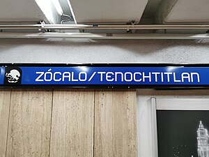
Zócalo/Tenochtitlan metro station
Mexico City Metro station
Distance: Approx. 79 meters
Latitude and longitude: 19.433248,-99.1329
Zócalo/Tenochtitlan metro station is a station of the Mexico City Metro in the historic center of the city, in the Cuauhtémoc borough. It is an underground station with two side platforms, serving Line 2 (the Blue Line) between Allende and Pino Suárez metro stations. Zócalo/Tenochtitlan metro station is located at the heart of the city's downtown, within the vicinity of the National Palace, the Metropolitan Cathedral, and the archaeological remains of Tenochtitlan's main temple, Templo Mayor, among other landmarks.
Indice de Precios y Cotizaciones
Mexican stock market index
Distance: Approx. 83 meters
Latitude and longitude: 19.43333333,-99.13333333
The Índice de Precios y Cotizaciones (IPC) is the weighted measurement index of 35 stocks traded on the Bolsa Mexicana de Valores. The recomposition of the index has its methodology originating and exposing on the BMV, and may change every quarter.

Zócalo
Plaza de la Constitución, Mexico City
Distance: Approx. 25 meters
Latitude and longitude: 19.43277778,-99.13305556
Zócalo (Spanish pronunciation: [ˈsokalo]) is the common name of the main square in central Mexico City. Prior to the colonial period, it was the main ceremonial center in the Aztec city of Tenochtitlan. The plaza used to be known simply as the "Main Square" (Plaza Mayor) or "Arms Square" (Plaza de Armas), and today its formal name is Plaza de la Constitución (Constitution Square).

Greater Mexico City
Conurbation centered around Mexico City
Distance: Approx. 10 meters
Latitude and longitude: 19.43251944,-99.13315833
Greater Mexico City is the conurbation around Mexico City, officially called the Metropolitan Area of the Valley of Mexico (Spanish: Zona metropolitana del Valle de México). It encompasses Mexico City itself and 60 adjacent municipalities of the State of Mexico and Hidalgo. Mexico City's metropolitan area is the economic, political, and cultural hub of Mexico.
Mexico City (former administrative division)
Distance: Approx. 83 meters
Latitude and longitude: 19.43333333,-99.13333333
Mexico City (Spanish: Ciudad de México) was the name of an administrative subdivision of the Mexican Federal District that existed from 1941 to 1970. Mexico City was formed by merging the Central Department (itself formed from the municipalities of Mexico, Tacuba, Tacubaya and Mixcoac) and the delegación of General Anaya. In 1970, Mexico City was split into the four delegaciones of Miguel Hidalgo, Benito Juárez, Cuauhtémoc and Venustiano Carranza.

First Mexican Republic
Period of Mexican history from 1824 to 1835
Distance: Approx. 83 meters
Latitude and longitude: 19.43333333,-99.13333333
The First Mexican Republic, known also as the First Federal Republic (Spanish: Primera República Federal), existed from 1824 to 1835. It was a federated republic, established by the Constitution of 1824, the first constitution of independent Mexico, and officially designated the United Mexican States (Spanish: Estados Unidos Mexicanos, ). It ended in 1835, when conservatives under Antonio López de Santa Anna transformed it into a unitary state, the Centralist Republic of Mexico.

Trolleybuses in Mexico City
Transit system in Mexico City
Distance: Approx. 83 meters
Latitude and longitude: 19.43333333,-99.13333333
The Mexico City trolleybus system (Spanish: Red de Trolebuses de la Ciudad de México) serves Mexico City, the capital city of Mexico, and is operated by Servicio de Transportes Eléctricos. The system opened on 9 March 1951. As of mid-2014, the system had 8 lines and the operable fleet included around 360 trolleybuses.

Second Federal Republic of Mexico
Period of Mexican history from 1846 to 1863
Distance: Approx. 83 meters
Latitude and longitude: 19.43333333,-99.13333333
The Second Federal Republic of Mexico (Spanish: Segunda República Federal de México) refers to the period of Mexican history involving a second attempt to establish a federal government in Mexico after the fall of the unitary Centralist Republic of Mexico in 1846 at the start of the Mexican-American War. It would last up until the Second French Intervention in Mexico led to the proclamation of the Second Mexican Empire in 1863. The period of the Second Federal Republic prove to be one of the most eventful periods in Mexican history, experiencing two foreign invasions, the loss of half of the national territory, constitutional change, and a civil war.

Mexico City Alebrije Parade
Distance: Approx. 19 meters
Latitude and longitude: 19.43270278,-99.13335
The Mexico City Alebrije Parade is an annual event to honor Mexican handcrafts and folk art, especially a hard kind of papier-mâché called “cartonería” and the creation of fantastic figures with it called “alebrijes.” Alebrijes are chimera-like creatures credited to artisan Pedro Linares painted in bright colors. The alebrijes for the parade are larger than anything Linares created, up to four meters in height and three meters in width. The parade begins on midday on a Saturday in late October in the historic center of Mexico City.

Bust of Cuauhtémoc
Sculpture in Mexico City, Mexico
Distance: Approx. 24 meters
Latitude and longitude: 19.43277778,-99.13333333
The bust of Cuauhtémoc was created by artist Jesús Fructuoso Contreras at the end of the 19th century. It was originally conceived by the artist as part of a set of sculptures of important Mexican historical figures that were installed in the Paseo de la Reforma between the years 1895 and 1899; however, the bust went on to spend many years housed in the atrium of the Mexico City Metropolitan Cathedral and only seen by the public during commemoration ceremonies. In 2007, as part of a remodeling effort in the Centro Histórico, the bust was moved to its current location at the Plaza de la Constitucion in Mexico City, Mexico.
Weather in this IP's area
light rain
14 Celsius
13 Celsius
13 Celsius
14 Celsius
1015 hPa
85 %
1015 hPa
782 hPa
10000 meters
4.12 m/s
340 degree
100 %
06:22:59
18:45:25