Country:
 Chinese mainland
Region:
City:
Latitude and Longitude:
Time Zone:
Postal Code:
IP information under different IP Channel
ip-api
Country
Region
City
ASN
Time Zone
ISP
Blacklist
Proxy
Latitude
Longitude
Postal
Route
IPinfo
Country
Region
City
ASN
Time Zone
ISP
Blacklist
Proxy
Latitude
Longitude
Postal
Route
MaxMind
Country
Region
City
ASN
Time Zone
ISP
Blacklist
Proxy
Latitude
Longitude
Postal
Route
Luminati
Country
CNASN
Time Zone
Asia/Shanghai
ISP
Asia Pacific Broadband Wireless Communications Inc
Latitude
Longitude
Postal
db-ip
Country
Region
City
ASN
Time Zone
ISP
Blacklist
Proxy
Latitude
Longitude
Postal
Route
ipdata
Country
Region
City
ASN
Time Zone
ISP
Blacklist
Proxy
Latitude
Longitude
Postal
Route
Popular places and events near this IP address
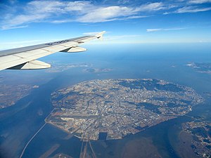
Xiamen Island
Island in Fujian, China
Distance: Approx. 5198 meters
Latitude and longitude: 24.4932,118.1363
Xiamen Island, alternately known as Amoy Island from its Hokkien pronunciation, is an island in southeastern Fujian, China, on the Taiwan Strait. It is administered by the People's Republic of China as the Huli and Siming urban districts of the sub-provincial city of Xiamen. The Gaoji Causeway is to the North, the old Yundang Harbor (now an inclosed lake), is to the West.
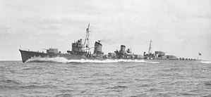
Japanese destroyer Amatsukaze (1939)
Kagerō-class destroyer
Distance: Approx. 2583 meters
Latitude and longitude: 24.5,118.16666667
Amatsukaze (天津風, "Heavenly Wind") was a Kagerō-class destroyer of the Imperial Japanese Navy. Captained by Tameichi Hara throughout 1942, Amatsukaze saw heavy combat. She took part in the capture of several key areas in the Philippines and Dutch East Indies, notably when she captured the port of Davao, bombarding the shores and destroying attempts by machine gunners to halt the landings and destroying a Philippine oil tanker in the process.
Amoy Operation
Distance: Approx. 5203 meters
Latitude and longitude: 24.5,118.138
The Amoy Operation, also known as the Battle of Xiamen (Chinese: 廈門戰鬥) was part of a campaign by Japan during the Second Sino-Japanese War to blockade China to prevent it from communicating with the outside world and importing needed arms and materials. Control of Amoy Island would provide a base to make the blockade of Fujian province more effective. Like the Canton Operation, the Amoy Operation was overseen by Koichi Shiozawa (1881-1943), who was the commander-in-chief of the Fifth Fleet during the Second Sino-Japanese War (1937-1945).

Huli, Xiamen
District in Fujian, China
Distance: Approx. 5862 meters
Latitude and longitude: 24.52055556,118.14333333
Huli (simplified Chinese: 湖里区; traditional Chinese: 湖里區; pinyin: ; Pe̍h-ōe-jī: Ô͘-lí-khu) is one of the administrative districts of the city of Xiamen, Fujian, China.
Xiamen Shuangshi High School
Public school
Distance: Approx. 4594 meters
Latitude and longitude: 24.51586,118.15569
Xiamen Shuangshi High School (Shuangshi; simplified Chinese: 福建省厦门双十中学; traditional Chinese: 福建省廈門雙十中學; Pe̍h-ōe-jī: Hok-kiàn-séng Ē-mn̂g Siang-sip Tiong-o'h), also known as Xiamen No. 8 High School, is a public high school including both junior division (Secondary School, Grades 7-9) and senior division (High School, Grades 10-12). Shuangshi was founded in October 1919 by a group of overseas Chinese individuals residing in the Philippines, along with prominent business figures in Xiamen.

SM City Xiamen
Shopping mall in Xiamen, Fuhian, China
Distance: Approx. 6817 meters
Latitude and longitude: 24.503609,118.122549
SM City Xiamen is a shopping centre in Xiamen city, Fujian province, China. It is owned by SM Prime Holdings, the largest retail and mall operator in the Philippines. It is the first SM Supermall on mainland China, which opened on 13 December 2001.

Xiamen Bay
Distance: Approx. 6570 meters
Latitude and longitude: 24.5,118.25
Xiamen Bay, formerly known as Amoy Bay, is a partially enclosed bay off the coast of Xiamen in China's Fujian Province. It is bound by the Kinmen Islands and the Taiwan Strait.

Xiamen bus fire
Murder-suicide attack in Xiamen, China
Distance: Approx. 2771 meters
Latitude and longitude: 24.49,118.16
On 7 June 2013, a mass murder-suicide attack occurred on a bus in Xiamen, Fujian province, China. A bus operating for the Xiamen BRT caught fire and exploded on an elevated lane near the Jinshan stop; 47 people died and 34 were injured.

Hujingtou Battle Museum
Museum in Lieyu, Kinmen, Taiwan
Distance: Approx. 6279 meters
Latitude and longitude: 24.44638889,118.23111111
The Hujingtou Battle Museum (traditional Chinese: 湖井頭戰史館; simplified Chinese: 湖井头战史馆; pinyin: Hújǐngtóu Zhànshǐguǎn) is a museum in Kinmen National Park, Lieyu Township, Kinmen County, Taiwan.

Wutong Ferry Terminal
Port in People's Republic of China
Distance: Approx. 5267 meters
Latitude and longitude: 24.5333,118.1884
Wutong Ferry Terminal or Wutong Port (simplified Chinese: 五通码头; traditional Chinese: 五通碼頭; pinyin: Wǔtōng Mǎtóu; Pe̍h-ōe-jī: Ngóu-thong Bé-thâu) is located on the North East coastline of Xiamen Island in the city of Xiamen, Fujian, China. It is a modern ferry terminal allowing hourly ferry services to the Taiwanese controlled Kinmen Island. It features immigration facilities and check-in services for Kinmen Airport allowing for seamless transfers between many cities in Taiwan and the Chinese mainland.

Shi Islet
Islet west of Taiwan.
Distance: Approx. 5267 meters
Latitude and longitude: 24.4557079,118.2269356
Shi Islet (Chinese: 獅嶼; pinyin: Shī Yǔ; Pe̍h-ōe-jī: sai-sū; lit. 'Lion Islet'; also Shi Yu, Shih Yü, Shiyu, Shiyu Islet and Lion Islet) is an islet located northwest of Lesser Kinmen (Lieyu) in Lieyu Township, Kinmen County (Quemoy), Fujian Province, Republic of China (Taiwan). Military personnel are stationed on Shi Islet.

Binlang Islet
Islet west of Lesser Kinmen, Taiwan (ROC).
Distance: Approx. 5622 meters
Latitude and longitude: 24.43666667,118.19888889
Binlang Islet (Chinese: 檳榔嶼; pinyin: bīn láng yǔ; Pe̍h-ōe-jī: pin-nn̂g-sū; lit. 'areca nut islet') is an islet located in Lieyu Township, Kinmen County (Quemoy), Taiwan (ROC). The islet can be seen from the shore near Lingshui Lake and from the shore near Shaxi Fort (沙溪堡) in the southwestern part of Lesser Kinmen (Lieyu) as well as from Siming District, Xiamen (Amoy), Fujian, China (PRC).
Weather in this IP's area
scattered clouds
27 Celsius
29 Celsius
27 Celsius
27 Celsius
1017 hPa
78 %
1017 hPa
1015 hPa
10000 meters
8 m/s
50 degree
40 %
06:06:47
17:37:19