Country:
Region:
City:
Latitude and Longitude:
Time Zone:
Postal Code:
IP information under different IP Channel
ip-api
Country
Region
City
ASN
Time Zone
ISP
Blacklist
Proxy
Latitude
Longitude
Postal
Route
Luminati
Country
Region
11
ASN
Time Zone
Asia/Seoul
ISP
DLIVE
Latitude
Longitude
Postal
IPinfo
Country
Region
City
ASN
Time Zone
ISP
Blacklist
Proxy
Latitude
Longitude
Postal
Route
db-ip
Country
Region
City
ASN
Time Zone
ISP
Blacklist
Proxy
Latitude
Longitude
Postal
Route
ipdata
Country
Region
City
ASN
Time Zone
ISP
Blacklist
Proxy
Latitude
Longitude
Postal
Route
Popular places and events near this IP address

Uijeongbu
City in Gyeonggi, South Korea
Distance: Approx. 805 meters
Latitude and longitude: 37.74861111,127.03888889
Uijeongbu (Korean: 의정부; Korean pronunciation: [ɰi.dʑʌŋ.bu]) is a city in Gyeonggi Province, South Korea.

Roman Catholic Diocese of Uijeongbu
Roman Catholic diocese in South Korea
Distance: Approx. 495 meters
Latitude and longitude: 37.73805556,127.03388889
The Diocese of Uijeongbu (Latin: Dioecesis Uijongbunensis), also romanized Uijongbu, is a particular church of the Latin Church of the Roman Catholic Church in South Korea. It is the newest diocese in South Korea, erected from the Archdiocese of Seoul on June 24, 2004 by the orders of Pope John Paul II, and a suffragan diocese of the same. Its mother church is the Cathedral of the Sacred Heart of Mary in Uijeongbu, Gyeonggi-do.

Camp Red Cloud
Former US Army camp in South Korea
Distance: Approx. 1185 meters
Latitude and longitude: 37.75194444,127.02777778
Camp Red Cloud (CRC, Korean: 캠프 레드 클라우드) was a United States Army camp located in the city of Uijeongbu, between Seoul and the Korean Demilitarized Zone (DMZ). CRC was transferred to the South Korean government in February 2022. The installation was renamed after Medal of Honor recipient Corporal Mitchell Red Cloud Jr.

Ganeung Station
Metro station in Uijeongbu, South Korea
Distance: Approx. 1106 meters
Latitude and longitude: 37.74833333,127.04416667
Ganeung Station is a metro station on the Line 1 of the Seoul Metropolitan Subway. The station is located in northern Uijeongbu and previously served as the northern terminus for Line 1 before its extension to Soyosan.
Uijeongbu Station
Metro station in Uijeongbu, South Korea
Distance: Approx. 1175 meters
Latitude and longitude: 37.73805556,127.04611111
Uijeongbu Station is a station on the Gyeongwon Line in South Korea. It is also served by trains on Seoul Subway Line 1.

Battle of Uijeongbu (1951)
Distance: Approx. 85 meters
Latitude and longitude: 37.743164,127.03448
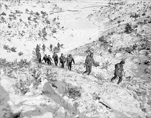
The Battle of Uijeongbu, also known as the Battle of Uijongbu, was fought between 1 and 4 January 1951, at Uijeongbu, South Korea, as part of the United Nations Command (UN) retreat after the third Chinese People's Volunteer Army (PVA) offensive after entering the Korean War. The 3rd Battalion, Royal Australian Regiment (3 RAR) had been defending the approaches north of Seoul, as part of the withdrawal of the United Nations forces and tasked with slowing the Chinese advance to allow the withdrawal of the United States 8th Army.
Uijeongbu High School
Public boarding school in Uijeongbu, Gyeonggi Province, South Korea
Distance: Approx. 1362 meters
Latitude and longitude: 37.75455,127.03131
Uijeongbu High School (Korean: 의정부고등학교, Hanja: 議政府高等學校), also known as "'UIGO'", is a public boarding high school located in Ganeung-dong, Uijeongbu, South Korea. The school was established on January 5, 1974, and opened its doors on March 6, 1974. Uijeongbu High School requires the completion of an application and admissions test by applicant students.

Beomgol station
Metro station in Uijeongbu, South Korea
Distance: Approx. 1753 meters
Latitude and longitude: 37.7287,127.0436
Beomgol Station (Korean: 범골역) is a station of the U Line in Shingok-dong, Uijeongbu, Gyeonggi Province, South Korea.

LRT Uijeongbu station
Metro station in Uijeongbu, South Korea
Distance: Approx. 1003 meters
Latitude and longitude: 37.7373,127.0433
LRT Uijeongbu Station (Korean: 경전철의정부역; Hanja: 輕電鐵議政府驛) is a station of the U Line in Uijeongbu-dong, Uijeongbu, Gyeonggi-do, South Korea. The station is unrelated to the Uijeongbu Station of Korail.

Uijeongbu City Hall station
Metro station in Uijeongbu, South Korea
Distance: Approx. 385 meters
Latitude and longitude: 37.7391,127.0348
Uijeongbu City Hall Station (Korean: 의정부시청역; Hanja: 議政府市廳驛) is a station of the U Line in Uijeongbu-dong, Uijeongbu, Gyeonggi-do, South Korea.

Heungseon station
Metro station in Uijeongbu, South Korea
Distance: Approx. 275 meters
Latitude and longitude: 37.7432,127.037
Heungseon Station (Korean: 흥선역) is a station of the U Line in Uijeongbu-dong, Uijeongbu, Gyeonggi-do, South Korea.

Uijeongbujungang station
Metro station in Uijeongbu, South Korea
Distance: Approx. 1379 meters
Latitude and longitude: 37.7436,127.0496
Uijeongbujungang Station (Korean: 의정부중앙역; Hanja: 議政府中央驛) is a station of the U Line in Uijeongbu-dong, Uijeongbu, Gyeonggi-do, South Korea.
Weather in this IP's area
overcast clouds
-1 Celsius
-1 Celsius
-1 Celsius
-0 Celsius
1033 hPa
47 %
1033 hPa
1025 hPa
10000 meters
1.22 m/s
1.73 m/s
80 degree
90 %
07:16:20
17:18:28
