Country:
 South Korea
Region:
City:
Latitude and Longitude:
Time Zone:
Postal Code:
IP information under different IP Channel
ip-api
Country
Region
City
ASN
Time Zone
ISP
Blacklist
Proxy
Latitude
Longitude
Postal
Route
IPinfo
Country
Region
City
ASN
Time Zone
ISP
Blacklist
Proxy
Latitude
Longitude
Postal
Route
MaxMind
Country
Region
City
ASN
Time Zone
ISP
Blacklist
Proxy
Latitude
Longitude
Postal
Route
Luminati
Country
KRRegion
11
ASN
Time Zone
Asia/Seoul
ISP
DLIVE
Latitude
Longitude
Postal
db-ip
Country
Region
City
ASN
Time Zone
ISP
Blacklist
Proxy
Latitude
Longitude
Postal
Route
ipdata
Country
Region
City
ASN
Time Zone
ISP
Blacklist
Proxy
Latitude
Longitude
Postal
Route
Popular places and events near this IP address

Gil-dong station
Metro station in South Korea
Distance: Approx. 2209 meters
Latitude and longitude: 37.53777778,127.14
Gil-dong Station is a subway station on Seoul Subway Line 5 in Gangdong District, Seoul. There is a connecting track from this station to Dunchon-dong Station on the Macheonji Line of Line 5, but it is a return train track for the arrival and departure of the Godeok Vehicle Business Office and has nothing to do with passenger operations.

Sangil-dong station
Metro station in South Korea
Distance: Approx. 1273 meters
Latitude and longitude: 37.55666667,127.16583333
Sangil-dong station is the subway station of Line 5 in Gangdong-gu, Seoul. Seoul Metro have extended the subway line from this station to Hanam Geomdansan in the nearby city of Hanam. The South Korean government plans to build a new apartment complex roughly 2 million pyeong in size.

Amsa-dong
Place in South Korea
Distance: Approx. 1962 meters
Latitude and longitude: 37.56049444,127.13021389
Amsa-dong is a dong (neighbourhood) of Gangdong District in Seoul, South Korea. The dong is well known for the Amsa-dong Prehistoric Settlement Site, in which Neolithic remains were excavated after a large amount of diagonal-line patterned earthenware(빗살무늬토기) was exposed by a flood in 1925. It is thought to be a Jomonic settlement which existed prior to the spread of Songgukri-cultural sphere in Korean peninsula during the Korean bronze age.

Gangil-dong
Place in South Korea
Distance: Approx. 2019 meters
Latitude and longitude: 37.5609,127.1733
Gangil-dong is a dong (neighborhood) of Gangdong District, Seoul, South Korea. Gangil-dong is located on the easternmost side of Seoul. Originally a small farming village where development was prohibited due to its location at Seoul's greenbelt, the city's new developments projects in the 21st century lead to a complete transformation of this neighborhood.

Hanyoung Foreign Language High School
High school in Seoul, South Korea
Distance: Approx. 961 meters
Latitude and longitude: 37.54805556,127.15722222
Hanyoung Foreign Language High School (Korean: 한영외국어고등학교) is a high school in South Korea. Located in southeast Seoul, South Korea, the medium-sized college preparatory school was founded in 1990.
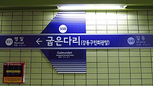
Gubeundari station
Train station in South Korea
Distance: Approx. 1339 meters
Latitude and longitude: 37.54555556,127.14277778
Gubeundari Station is a subway station on Seoul Subway Line 5 in Gangdong District, Seoul.

Myeongil station
Train station in South Korea
Distance: Approx. 807 meters
Latitude and longitude: 37.55138889,127.14388889
Myeongil Station is a subway station on Seoul Subway Line 5 in Gangdong-gu, Seoul.

Godeok station
Train station in South Korea
Distance: Approx. 240 meters
Latitude and longitude: 37.555,127.15416667
Godeok Station is a subway station on Seoul Subway Line 5 in Gangdong District, Seoul. It links to Baejae High School, Myungil High School, Gwangmun High School, Hanyoung High School, and Hanyoung Foreign Language High School. It will be part of Seoul Subway Line 9 in 2028.

Amsa station
Station of the Seoul Metropolitan Subway
Distance: Approx. 2202 meters
Latitude and longitude: 37.55,127.1275
Amsa station (Korean: 암사; Hanja: 岩寺) is a subway station on Line 8 of the Seoul Metropolitan Subway. The station is located in the Amsa and Cheonho neighborhoods in Gangdong District, Seoul. The station is the Northern terminus of the line and is approximately 31 minutes by train from Moran station, the Southern terminus.

Guri–Amsa Bridge
Bridge in Seoul, South Korea
Distance: Approx. 2300 meters
Latitude and longitude: 37.5692,127.1321
The Guri–Amsa Bridge (Korean: 구리암사대교) crosses the Han River in South Korea and connects the city of Guri and Gangdong-gu (district) in Seoul. Construction on the bridge began in September 2006, and there was controversy regarding the naming of the bridge. The Seoul City Naming Committee suggested "Amsa Bridge" in reference to Amsa-dong located in Gangdong, while the city of Guri suggested "Guri Bridge." Eventually, the Naming Committee compromised by naming the bridge "Guri–Amsa Bridge." The bridge was partially opened on November 20, 2014, and opened in its entirety, including all entrances and exits, on June 29, 2015.

Gangil station
Metro station in Seoul, South Korea
Distance: Approx. 2160 meters
Latitude and longitude: 37.5575,127.17583333
Gangil Station (Korean: 강일역) is a subway station on the Hanam Line of Seoul Subway Line 5, located in Gangdong District, Seoul, South Korea.

Amsa History Park station
Station of the Seoul Metropolitan Subway
Distance: Approx. 1396 meters
Latitude and longitude: 37.55679,127.13578
Amsa History Park station (Korean: 암사역사공원) is a subway station on Line 8 of the Seoul Metropolitan Subway system.
Weather in this IP's area
overcast clouds
18 Celsius
18 Celsius
16 Celsius
18 Celsius
1012 hPa
91 %
1012 hPa
1007 hPa
10000 meters
1.62 m/s
3.57 m/s
352 degree
97 %
06:43:05
17:49:18