101.235.134.120 - IP Lookup: Free IP Address Lookup, Postal Code Lookup, IP Location Lookup, IP ASN, Public IP
Country:
Region:
City:
Location:
Time Zone:
Postal Code:
IP information under different IP Channel
ip-api
Country
Region
City
ASN
Time Zone
ISP
Blacklist
Proxy
Latitude
Longitude
Postal
Route
Luminati
Country
Region
11
City
seodaemungu
ASN
Time Zone
Asia/Seoul
ISP
DLIVE
Latitude
Longitude
Postal
IPinfo
Country
Region
City
ASN
Time Zone
ISP
Blacklist
Proxy
Latitude
Longitude
Postal
Route
IP2Location
101.235.134.120Country
Region
gyeonggi-do
City
guri
Time Zone
Asia/Seoul
ISP
Language
User-Agent
Latitude
Longitude
Postal
db-ip
Country
Region
City
ASN
Time Zone
ISP
Blacklist
Proxy
Latitude
Longitude
Postal
Route
ipdata
Country
Region
City
ASN
Time Zone
ISP
Blacklist
Proxy
Latitude
Longitude
Postal
Route
Popular places and events near this IP address

Guri
City in Gyeonggi, South Korea
Distance: Approx. 946 meters
Latitude and longitude: 37.6,127.15
Guri (Korean: 구리; lit. Town of Nine Villages; Korean pronunciation: [ku.ɾi]) is a city in Gyeonggi Province, South Korea. It is located immediately to the east of Seoul, in the heart of the Capital Metropolitan Area.

Jungnang District
Autonomous district in Seoul, South Korea
Distance: Approx. 4216 meters
Latitude and longitude: 37.6064,127.0926
Jungnang District (Korean: 중랑구; RR: Jungnang-gu) is one of the 25 gu, or districts, of Seoul, South Korea. It is located on the north side of the Han River. It is characterized by a typical residential area with many natural green areas such as Yongma, Mangwoo, and Bonghwasan Mountain.

Mangu Station
Train station in Jungnang-gu, Seoul, South Korea
Distance: Approx. 4150 meters
Latitude and longitude: 37.5992,127.09235
Mangu Station is a station on the Gyeongui–Jungang Line, and the Gyeongchun Line since 21 December 2010. The station was Seoul's main distribution center of charcoal briquettes in the 1950s and 1960s, extracted and manufactured in southern Gangwon province. These briquettes were widely used by people to weather harsh winters when Korea was a developing country and recovering from the Korean War.

Yangwon Station
Station of the Seoul Metropolitan Subway
Distance: Approx. 2913 meters
Latitude and longitude: 37.60654,127.10789
Yangwon Station is a station on the Gyeongui–Jungang Line. Geographically, it is the easternmost train/metro station in Seoul north of the Han River.

Guri station
Train station in Guri, South Korea
Distance: Approx. 558 meters
Latitude and longitude: 37.60277778,127.14308889
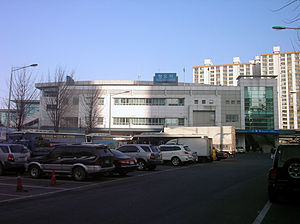
Guri station is a train station on the Gyeongui–Jungang Line. It is located in Inchang-dong, Guri, behind GS Square, a large department store in the central city area. Guri station is in Gyeonggi-do, whereas the previous western station, Yangwon station, is in Seoul.

Amsa-dong
Place in South Korea
Distance: Approx. 4330 meters
Latitude and longitude: 37.56049444,127.13021389
Amsa-dong (Korean: 암사동) is a dong (neighbourhood) of Gangdong District, Seoul, South Korea. The dong is well known for the Amsa-dong Prehistoric Settlement Site, in which Neolithic remains were excavated after a large amount of diagonal-line patterned earthenware(빗살무늬토기) was exposed by a flood in 1925. It is thought to be a Jomonic settlement which existed prior to the spread of Songgukri-cultural sphere in Korean peninsula during the Korean bronze age.
GS Champions Park
Football training center in Guri, South Korea
Distance: Approx. 3904 meters
Latitude and longitude: 37.56748,127.11923
The GS Champions Park is the training center of FC Seoul. It is located in Guri, east of nearby Seoul. In 1983, it was built by GS Sports, then known as Lucky-Goldstar Sports.

Donong Station
Train station in South Korea
Distance: Approx. 2184 meters
Latitude and longitude: 37.6083,127.161
Donong Station is a train station on the Gyeongui–Jungang Line.
Hwarang Archery Field
South Korean archery field
Distance: Approx. 4373 meters
Latitude and longitude: 37.62166667,127.09916667
The Hwarang Archery Field is an archery field constructed between November 1985 and January 1986, and then renovated between May and August 1988. It hosted the archery competitions for the 1988 Summer Olympics in Seoul.
Sinnae Station
Station of the Seoul Metropolitan Subway
Distance: Approx. 3562 meters
Latitude and longitude: 37.6129,127.1032
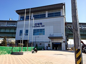
Sinnae station (Korean: 신내역; Hanja: 新內驛) is a railway station on the Gyeongchun Line and Seoul Subway Line 6. The station is located near the Sinnae train depot, which is the depot of Line 6. Line 6 currently only has 1 track and 1 platform, however, in the future, the Line 6 station will be expanded to 2 tracks and 2 platforms.
Donggureung
Royal tomb in South Korea
Distance: Approx. 2739 meters
Latitude and longitude: 37.622608,127.132075
Donggureung (lit. 'The Nine Eastern Royal Tombs'), is a cluster of royal tombs from the Joseon dynasty, the largest of its kind in South Korea. 17 Joseon kings and queens are buried here. The cluster also houses a myo-type tomb (of a royal family member).

Guri–Amsa Bridge
Bridge in Seoul, South Korea
Distance: Approx. 3346 meters
Latitude and longitude: 37.5692,127.1321
The Guri–Amsa Bridge (Korean: 구리암사대교) crosses the Han River in South Korea and connects the city of Guri and Gangdong-gu (district) in Seoul. Construction on the bridge began in September 2006, and there was controversy regarding the naming of the bridge. The Seoul City Naming Committee suggested "Amsa Bridge" in reference to Amsa-dong located in Gangdong, while the city of Guri suggested "Guri Bridge." Eventually, the Naming Committee compromised by naming the bridge "Guri–Amsa Bridge." The bridge was partially opened on November 20, 2014, and opened in its entirety, including all entrances and exits, on June 29, 2015.
Weather in this IP's area
clear sky
3 Celsius
3 Celsius
2 Celsius
4 Celsius
1028 hPa
28 %
1028 hPa
1024 hPa
10000 meters
1.03 m/s
90 degree

