Country:
 South Korea
Region:
City:
Latitude and Longitude:
Time Zone:
Postal Code:
IP information under different IP Channel
ip-api
Country
Region
City
ASN
Time Zone
ISP
Blacklist
Proxy
Latitude
Longitude
Postal
Route
IPinfo
Country
Region
City
ASN
Time Zone
ISP
Blacklist
Proxy
Latitude
Longitude
Postal
Route
MaxMind
Country
Region
City
ASN
Time Zone
ISP
Blacklist
Proxy
Latitude
Longitude
Postal
Route
Luminati
Country
KRRegion
11
City
jungnanggu
ASN
Time Zone
Asia/Seoul
ISP
DLIVE
Latitude
Longitude
Postal
db-ip
Country
Region
City
ASN
Time Zone
ISP
Blacklist
Proxy
Latitude
Longitude
Postal
Route
ipdata
Country
Region
City
ASN
Time Zone
ISP
Blacklist
Proxy
Latitude
Longitude
Postal
Route
Popular places and events near this IP address

Duksung Women's University
Private university in Seoul, South Korea
Distance: Approx. 1364 meters
Latitude and longitude: 37.6509,127.0169
Duksung Women's University is a private university in Seoul, South Korea founded in 1920.

Mia station
Distance: Approx. 2799 meters
Latitude and longitude: 37.6266,127.026
Mia Station is an underground station on the Seoul Subway Line 4. It is located in Mia-dong, Gangbuk-gu, Seoul, South Korea. Its station subname is Seoul Cyber Univ., where said university is nearby.
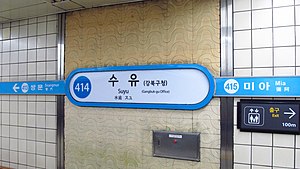
Suyu station
Station of the Seoul Metropolitan Subway
Distance: Approx. 2071 meters
Latitude and longitude: 37.63806,127.02574
Suyu Station (Korean: 수유역; Hanja: 水踰驛) is an underground station on the Seoul Subway Line 4 in Suyu-dong, Gangbuk-gu, Seoul, South Korea.

Ssangmun station
Station of the Seoul Metropolitan Subway
Distance: Approx. 2771 meters
Latitude and longitude: 37.64859,127.03471
Ssangmun Station (Korean: 쌍문역; Hanja: 雙門驛) is an underground station on Seoul Subway Line 4 in Dobong-gu, Seoul, South Korea.

Bukhansan
Highest mountain in Seoul, South Korea
Distance: Approx. 2033 meters
Latitude and longitude: 37.6608,126.9933
Bukhansan (Korean: 북한산, lit. 'North Han Mountain'), or Bukhan Mountain, is a mountain on the northern periphery of Seoul, South Korea. There are three major peaks, Baegundae 836.5 meters (2,744 ft), Insubong 810.5 meters (2,659 ft), Mangyeongdae 787.0 meters (2,582.0 ft). Because of its height and the fact that it borders a considerable portion of the city, Bukhansan is a major landmark visible from most city districts.
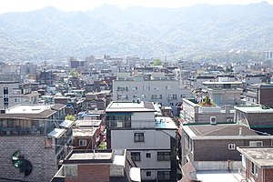
Gangbuk District
Autonomous district in Seoul, South Korea
Distance: Approx. 2010 meters
Latitude and longitude: 37.63961111,127.02565556
Gangbuk District (Gangbuk-gu) is one of the 25 gu which make up the city of Seoul, South Korea. Its name is derived from it being located at the north of Han river. It was created from neighbouring Dobong District (도봉구) in 1995.
Onggi Folk Museum
Private museum specializing in Korean earthenware in Seoul, South Korea
Distance: Approx. 1470 meters
Latitude and longitude: 37.6545,127.0146
The Onggi Folk Museum, located in Seoul, South Korea is a private museum specializing in onggi, Korean earthenware which is used for storage and utilitarian purposes. It was established as the Goryeo Folk Museum (Korean: 고려민속박물관) in 1991 and later was changed to the current name. The museum consists of three-story building and an outdoor exhibition hall where 3,300 items of onggi and other items such as dancheong patterns, Korean traditional decorative coloring used for building are exhibited.

Doseonsa
Buddhist temple in Seoul, South Korea
Distance: Approx. 1720 meters
Latitude and longitude: 37.65527778,126.98972222
Doseonsa (Korean: 도선사) is a Buddhist temple of the Jogye Order in Seoul, South Korea, named after its supposed founder, Doseon. It is located at 264 Ui-dong, in the Gangbuk-gu area of the city and is the largest temple complex on Bukhansan, the most prominent mountain north of Seoul. The temple was dedicated in 862, though none of its original structures survive.
Insu-dong
Place in South Korea
Distance: Approx. 1076 meters
Latitude and longitude: 37.63485,127.00303889
Insu-dong (Korean: 인수동) is a dong, neighbourhood of Gangbuk-gu in Seoul, South Korea. From 30 June 2008, the former Suyu-5 and 6 dong were combined to form this dong.
Shinil High School
High School' in Gangbuk-gu, Seoul, South Korea
Distance: Approx. 2771 meters
Latitude and longitude: 37.628405,127.02768111
Shinil High School is a secondary school in Seoul, South Korea. It was founded in 1966, and has been designated as an autonomous private school by the Ministry of Education since 2009.

Bukhansanseong
Fortress in Gyeonggi, Seoul, South Korea
Distance: Approx. 1694 meters
Latitude and longitude: 37.6451,126.9845
The Bukhansanseong (Korean: 북한산성; lit. fortress of the mountains north of the Han) is a fortress located in Gyeonggi Province and Seoul, South Korea, dating back to the middle Joseon period. The present fort was completed in 1711, though plans for the structure date back to 1659.
Seoul Cyber University
Distance: Approx. 2633 meters
Latitude and longitude: 37.6298,127.0271
Seoul Cyber University (SCU) (Korean: 서울사이버대학교) is a Korean online university. SCU is located in Seoul, South Korea, where it has approximately 11,000 enrolled students and 100 faculty members among 9 schools. It has 19 departments.
Weather in this IP's area
broken clouds
24 Celsius
24 Celsius
24 Celsius
24 Celsius
1016 hPa
83 %
1016 hPa
1005 hPa
10000 meters
0.59 m/s
0.71 m/s
67 degree
67 %
06:15:32
18:37:40