101.128.123.171 - IP Lookup: Free IP Address Lookup, Postal Code Lookup, IP Location Lookup, IP ASN, Public IP
Country:
Region:
City:
Location:
Time Zone:
Postal Code:
IP information under different IP Channel
ip-api
Country
Region
City
ASN
Time Zone
ISP
Blacklist
Proxy
Latitude
Longitude
Postal
Route
Luminati
Country
ASN
Time Zone
Asia/Jakarta
ISP
PT. Cyberindo Aditama
Latitude
Longitude
Postal
IPinfo
Country
Region
City
ASN
Time Zone
ISP
Blacklist
Proxy
Latitude
Longitude
Postal
Route
IP2Location
101.128.123.171Country
Region
jawa timur
City
malang
Time Zone
Asia/Jakarta
ISP
Language
User-Agent
Latitude
Longitude
Postal
db-ip
Country
Region
City
ASN
Time Zone
ISP
Blacklist
Proxy
Latitude
Longitude
Postal
Route
ipdata
Country
Region
City
ASN
Time Zone
ISP
Blacklist
Proxy
Latitude
Longitude
Postal
Route
Popular places and events near this IP address

Malang
City in Java, Indonesia
Distance: Approx. 1124 meters
Latitude and longitude: -7.98,112.62
Malang (; Javanese: ꦏꦸꦛꦩꦭꦁ, romanized: Kutha Malang, Indonesian: Kota Malang), historically known as Tumapel, is an inland city in the Indonesian province of East Java. It has a history dating back to the age of the Singhasari Kingdom. It is the second most populous city in the province, with a population of 820,043 at the 2010 Census and 843,810 at the 2020 Census; the official estimate as of mid-2023 was 847,182 (comprising 421,340 males and 425,842 females).

Gajayana Stadium
Stadium in Indonesia
Distance: Approx. 762 meters
Latitude and longitude: -7.975513,112.624975
Gajayana Stadium (Stadion Gajayana) is a multi-purpose stadium in Malang, East Java, Indonesia. Gajayana Stadium is the oldest stadium in Indonesia. This stadium began to become the center of the city in 1924 until 1926.

Malang Regency
Regency in Indonesia
Distance: Approx. 40 meters
Latitude and longitude: -7.9797,112.6304
Malang Regency (Javanese: ꦏꦧꦸꦥꦠꦼꦤ꧀ꦩꦭꦁ; Pegon: كابوڤاتين مالاڠ; Osob Kiwalan: ngalaM) is the second largest regency in East Java, Indonesia, with a total area of 3,530.65 km (2,193.84 mi). It is rich in potential for agriculture, medicinal plants and tourism. It had a population of 2,446,218 people at the 2010 census and 2,654,448 at the 2020 Census; the official estimate as at mid 2023 was 2,711,103.
Roman Catholic Diocese of Malang
Roman Catholic diocese in East Java, Indonesia
Distance: Approx. 1414 meters
Latitude and longitude: -7.968772,112.624201
The Roman Catholic Diocese of Malang (Latin: Malangen(sis)) is a diocese located in the city of Malang in the ecclesiastical province of Semarang in Indonesia.

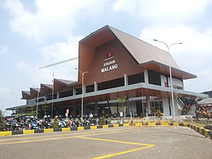
Malang railway station
Railway station in Indonesia
Distance: Approx. 817 meters
Latitude and longitude: -7.9778024,112.6372755
Malang Station is a railway station in Malang City, East Java. The station is located at an altitude of approximately +444 meters amsl. It is the largest train station in Malang City.
SMA Negeri 1 Malang
Distance: Approx. 607 meters
Latitude and longitude: -7.97673611,112.63460833
SMA Negeri 1 Malang, which stands for Sekolah Menengah Atas Negeri, is a state high school that is located at Tugu Utara No. 1, Malang, Jawa Timur, Indonesia. Together with SMA Negeri 4 and SMA Negeri 3, they are usually called SMA Tugu, since they are located at Tugu, one of the most beautiful and famous landscapes in Malang.
State University of Malang
University in Indonesia
Distance: Approx. 2294 meters
Latitude and longitude: -7.962995,112.618447
The State University of Malang (Indonesian: Universitas Negeri Malang, abbreviated as UM), formerly the Institute of Teacher Education and Educational Sciences of Malang (Indonesian: Institut Keguruan dan Ilmu Pendidikan Malang, abbreviated as IKIP Malang), is one of the state universities in Indonesia. Located in Malang and Blitar, East Java, UM was established in October 18, 1954 as PTPG Malang, as School of Education of Airlangga University, making it one of the oldest teaching institutes in Indonesia. UM was separated from Airlangga University on 20 May 1964 to become IKIP Malang.
Cathedral of Our Lady of Mount Carmel, Malang
Catholic church in Indonesia
Distance: Approx. 1488 meters
Latitude and longitude: -7.9684,112.6235
The Cathedral of Our Lady of Mount Carmel (Katedral Santa Maria Bunda Karmel) is a Roman Catholic cathedral in Malang, East Java, Indonesia, and seat of the Roman Catholic Diocese of Malang. The cathedral was built in 1934 in the Art Deco style with some neo-gothic influence by architect L. Estourgie, and is an example of the Dutch colonial architectural heritage in the city. It was originally named for St Teresa but was renamed in 1961.

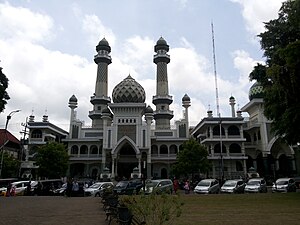
Great Mosque of Malang
Mosque in Malang, East Java, Indonesia
Distance: Approx. 272 meters
Latitude and longitude: -7.9823846,112.6296458
The Great Mosque of Malang is a mosque located in Malang, East Java, Indonesia. The mosque was built in 1890 and completed in 1903. The mosque is square-shaped, constructed with steel, and has a tajug (pyramid shaped rooftop ornament) on top.

Roti Bunz
Distance: Approx. 1772 meters
Latitude and longitude: -7.974185,112.615238
Roti Bunz is an Indonesian bakery, bistro, and coffeehouse chain based in Malang, East Java, Indonesia. The company was founded in 2012 by Yudi Haryanto.

Klojen
District in East Java, Indonesia
Distance: Approx. 410 meters
Latitude and longitude: -7.976408,112.629378
Klojen is a district in city of Malang, East Java, Indonesia.

Jasa Tirta I
Indonesian state owned water supply company
Distance: Approx. 2040 meters
Latitude and longitude: -7.965847,112.61845
Jasa Tirta I is an Indonesian stated-owned water supply company based in Malang, East Java, Indonesia.
Weather in this IP's area
overcast clouds
23 Celsius
24 Celsius
23 Celsius
23 Celsius
1012 hPa
94 %
1012 hPa
928 hPa
10000 meters
1.39 m/s
3.46 m/s
176 degree
100 %
