Country:
 Australia
Region:
City:
Latitude and Longitude:
Time Zone:
Postal Code:
IP information under different IP Channel
ip-api
Country
Region
City
ASN
Time Zone
ISP
Blacklist
Proxy
Latitude
Longitude
Postal
Route
IPinfo
Country
Region
City
ASN
Time Zone
ISP
Blacklist
Proxy
Latitude
Longitude
Postal
Route
MaxMind
Country
Region
City
ASN
Time Zone
ISP
Blacklist
Proxy
Latitude
Longitude
Postal
Route
Luminati
Country
AURegion
nsw
City
sydney
ASN
Time Zone
Australia/Sydney
ISP
Vodafone Australia Pty Ltd
Latitude
Longitude
Postal
db-ip
Country
Region
City
ASN
Time Zone
ISP
Blacklist
Proxy
Latitude
Longitude
Postal
Route
ipdata
Country
Region
City
ASN
Time Zone
ISP
Blacklist
Proxy
Latitude
Longitude
Postal
Route
Popular places and events near this IP address

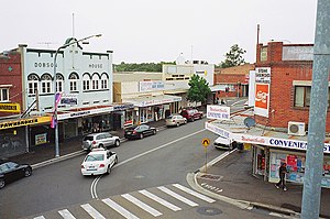
Westmead, New South Wales
Suburb of Sydney, New South Wales, Australia
Distance: Approx. 285 meters
Latitude and longitude: -33.80833333,150.98194444
Westmead is a suburb in Sydney, in the state of New South Wales, Australia. Westmead is located 26 kilometres west of the Sydney central business district in the local government areas of City of Parramatta and Cumberland Council and is part of the Greater Western Sydney region.

The Children's Hospital at Westmead
Hospital in New South Wales, Australia
Distance: Approx. 904 meters
Latitude and longitude: -33.8017,150.992
The Children's Hospital at Westmead (CHW; formerly Royal Alexandra Hospital for Children) is a children's hospital in Western Sydney. The hospital was founded in 1880 as "The Sydney Hospital for Sick Children". Its name was changed to the "Royal Alexandra Hospital for Children" on 4 January 1904 when King Edward VII granted use of the appellation 'Royal' and his consort, Queen Alexandra, consented to the use of her name.
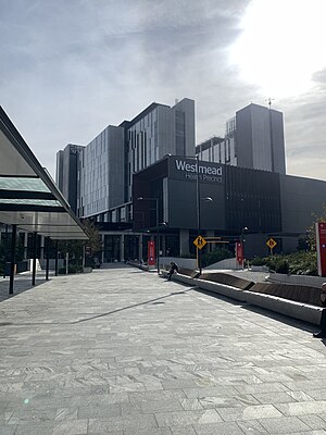
Westmead Hospital
Hospital in New South Wales, Australia
Distance: Approx. 464 meters
Latitude and longitude: -33.8045,150.9886
Westmead Hospital is a major teaching hospital in Sydney, Australia. Opened on 10 November 1978, the 975-bed hospital forms part of the Western Sydney Local Health District, and is a teaching hospital of Sydney Medical School at the University of Sydney. The hospital serves a population of 1.85 million people and is located on one of the largest health and hospital campuses in Australia.
Wentworthville, New South Wales
Suburb of Sydney, New South Wales, Australia
Distance: Approx. 1110 meters
Latitude and longitude: -33.80694444,150.9725
Wentworthville is a suburb in Sydney, in the state of New South Wales, Australia. Wentworthville is located 27 kilometres west of the Sydney central business district and is part of the Greater Western Sydney region. Wentworthville is split between the local government areas of the City of Parramatta and the Cumberland Council.

Wentworthville railway station
Railway station in Sydney, New South Wales, Australia
Distance: Approx. 1099 meters
Latitude and longitude: -33.80723889,150.9726278
Wentworthville railway station is a heritage-listed railway station located on the Main Western line, serving the Sydney suburb of Wentworthville. It is served by Sydney Trains T1 Western and T5 Cumberland line services.

Westmead railway station
Railway station in Sydney, New South Wales, Australia
Distance: Approx. 369 meters
Latitude and longitude: -33.80853056,150.9879722
Westmead railway station is located on the Main Western line, serving the Sydney suburb of Westmead. It is served by Sydney Trains T1 Western Line and T5 Cumberland Line services and NSW TrainLink Blue Mountains Line services.
Cumberland Hospital
Hospital in Sydney, Australia
Distance: Approx. 1123 meters
Latitude and longitude: -33.80187,150.99502
Cumberland Hospital is a public psychiatric hospital located in Westmead, in Sydney's west. Along with Bungarribee House, Blacktown Hospital it serves the mental health needs of Western Sydney. As a public hospital it is part of the Western Sydney Local Health District (WSLHD).
Children's Medical Research Institute
Australian medical research institute
Distance: Approx. 942 meters
Latitude and longitude: -33.80138889,150.99222222
Children's Medical Research Institute (CMRI) is an Australian medical research institute located in Westmead that conducts research into children's genetic diseases. As of 2019, current research is focused on cancer, birth defects, neurological conditions such as epilepsy, and gene therapy. Much of CMRI's cancer research focuses on telomeres (including telomerase) and the Alternative Lengthening of Telomeres (ALT) mechanism, which was discovered at CMRI in 1997.
Parramatta Marist High School
School in Australia
Distance: Approx. 121 meters
Latitude and longitude: -33.80583333,150.98472222
The Parramatta Marist High School is an independent Roman Catholic single-sex secondary day school for boys, located in Westmead, a suburb of the western region of Sydney, New South Wales, Australia. Founded in 1820 by John Therry, it was the first Catholic school in Australia, and is the oldest school in Australia. Parramatta Marist began under the direction of George Morley.

Westmead Institute for Medical Research
Distance: Approx. 715 meters
Latitude and longitude: -33.8033,150.9909
The Westmead Institute for Medical Research is a large medical research institute located at Westmead in the western suburbs of Sydney, Australia. The institute is closely affiliated with Sydney Medical School and Westmead Hospital and comprises approximately 450 medical research and support staff. Originally named the Westmead Millennium Institute for Medical Research, the institute was founded in 1996 through the merging of five research groups at the Westmead health campus, initially comprising just 40 medical researchers, and was renamed on 18 November 2015.
Westmead Medical Research Foundation
Distance: Approx. 464 meters
Latitude and longitude: -33.8045,150.9886
The Westmead Hospital Foundation is an Australian not-for-profit organisation which awards grants, provides fundraising support, and community advocacy for health care and medical research at Westmead in the western suburbs of Sydney.

Dairy Cottage, Parramatta
Building of historical significance in the Sydney suburb of Parramatta
Distance: Approx. 1134 meters
Latitude and longitude: -33.80662,150.99676
Dairy Cottage is a building of historical significance, located in Parramatta Park in the Sydney suburb of Parramatta. Built in 1798, it is one of the earliest residences in Australia and the only 18th Century convict-built cottage. Its history encompasses three distinct phases of occupation: first as the residence of a Second Fleet convict who developed the property into a thriving farm, second as a dairy which supplied milk products to the Governor's household and surrounding population, and third as a ranger's cottage.
Weather in this IP's area
overcast clouds
13 Celsius
13 Celsius
12 Celsius
14 Celsius
1023 hPa
88 %
1023 hPa
1020 hPa
10000 meters
0.45 m/s
0.89 m/s
321 degree
98 %
06:21:00
19:04:52