Country:
 Australia
Region:
City:
Latitude and Longitude:
Time Zone:
Postal Code:
IP information under different IP Channel
ip-api
Country
Region
City
ASN
Time Zone
ISP
Blacklist
Proxy
Latitude
Longitude
Postal
Route
IPinfo
Country
Region
City
ASN
Time Zone
ISP
Blacklist
Proxy
Latitude
Longitude
Postal
Route
MaxMind
Country
Region
City
ASN
Time Zone
ISP
Blacklist
Proxy
Latitude
Longitude
Postal
Route
Luminati
Country
AURegion
nsw
City
sydney
ASN
Time Zone
Australia/Sydney
ISP
Vodafone Australia Pty Ltd
Latitude
Longitude
Postal
db-ip
Country
Region
City
ASN
Time Zone
ISP
Blacklist
Proxy
Latitude
Longitude
Postal
Route
ipdata
Country
Region
City
ASN
Time Zone
ISP
Blacklist
Proxy
Latitude
Longitude
Postal
Route
Popular places and events near this IP address

Yagoona, New South Wales
Suburb of Sydney, New South Wales, Australia
Distance: Approx. 747 meters
Latitude and longitude: -33.9078,151.0251
Yagoona, a suburb of the local government area City of Canterbury-Bankstown, is located 20 kilometres south-west of the Sydney central business district, in the state of New South Wales, Australia. It is a part of the South-western Sydney region. Yagoona is an Aboriginal word meaning 'now' or 'today'.

Birrong railway station
Railway station in Sydney, New South Wales, Australia
Distance: Approx. 896 meters
Latitude and longitude: -33.893282,151.023913
Birrong railway station is located on the Bankstown line, serving the Sydney suburb of Birrong. It is served by Sydney Trains T3 Bankstown line services.

Birrong
Suburb of Sydney, New South Wales, Australia
Distance: Approx. 918 meters
Latitude and longitude: -33.89305556,151.02305556
Birrong, a suburb of local government area City of Canterbury-Bankstown, is located 22 kilometres south-west of the Sydney central business district, in the state of New South Wales, Australia, and is a part of the South-western Sydney region. Birrong shares its postcode of 2143 with neighbouring suburbs Regents Park and Potts Hill.

Yagoona railway station
Railway station in Sydney, New South Wales, Australia
Distance: Approx. 602 meters
Latitude and longitude: -33.90663056,151.0241972
Yagoona railway station is a station serving the Sydney suburb of Yagoona. It is served by Sydney Trains T6 services.

Regents Park, New South Wales
Suburb of Sydney, New South Wales, Australia
Distance: Approx. 1788 meters
Latitude and longitude: -33.88583333,151.02833333
Regents Park is a suburb in western Sydney, in the state of New South Wales, Australia. Regents Park is located 22 kilometres west of the Sydney central business district, in the local government area of Cumberland Council and City of Canterbury-Bankstown. Regents Park shares the postcode of 2143 with neighbouring suburbs Birrong and Potts Hill.

Potts Hill, New South Wales
Suburb of Sydney, New South Wales, Australia
Distance: Approx. 1410 meters
Latitude and longitude: -33.89,151.03
Potts Hill, a suburb of local government area City of Canterbury-Bankstown, is 21 kilometres south-west of the Sydney central business district, in the state of New South Wales, Australia. It is a part of the South-western Sydney region. Potts Hill shares its postcode of 2143 with neighbouring suburbs Regents Park and Birrong.
LaSalle Catholic College, Bankstown
School in Bankstown, New South Wales, Australia
Distance: Approx. 1356 meters
Latitude and longitude: -33.9082,151.0352
LaSalle Catholic College is an independent Roman Catholic comprehensive co-educational secondary day school, located in Bankstown, a south-western suburb of Sydney, New South Wales, Australia. The De La Salle Brothers run the college in the tradition of Saint John Baptist de La Salle. The college provides a Catholic and general education for students from Year 7 to Year 12, with oversight provided by the Sydney Catholic Schools of the Archdiocese of Sydney.

Bankstown Bunker
Historic site in New South Wales, Australia
Distance: Approx. 1905 meters
Latitude and longitude: -33.917,151.0149
The Bankstown Bunker, formerly known as Air Defence Headquarters Sydney (ADHQ Sydney), is a heritage-listed defunct Royal Australian Air Force (RAAF) operations facility, located on the corner of Marion and Edgar Street, in Condell Park, New South Wales, Australia. It was designed by the Allied Works Council and built from 1943 to 1944 by Stuart Bros Pty Ltd of Sydney. It is also known as Air Defence Headquarters Ruin Sydney (former), No.
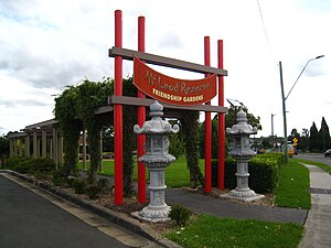
McLeod Reserve
Distance: Approx. 1101 meters
Latitude and longitude: -33.907848,151.032035
McLeod Reserve is a park situated along the Hume Highway in Bankstown, New South Wales, Australia.
Birrong Girls High School
School in Australia
Distance: Approx. 1314 meters
Latitude and longitude: -33.889825,151.02642778
Birrong Girls High School is a government-funded single-sex comprehensive secondary day school for girls, located on Cooper Road, Birrong, a western suburb of Sydney, in New South Wales, Australia. Established in 1957, the school enrolled approximately 790 students in 2018, from Year 7 to Year 12, of whom one percent identified as Indigenous Australians and 94 percent were from a language background other than English. The school is operated by the NSW Department of Education in accordance with a curriculum developed by the New South Wales Education Standards Authority; the principal is Zena Dabaja.

Bankstown Reservoir
Water tower in Bankstown, Sydney, NSW
Distance: Approx. 1599 meters
Latitude and longitude: -33.90549444,151.03965
Bankstown Reservoir is a heritage-protected water tower and a local landmark situated in the Sydney suburb of Bankstown, New South Wales, Australia. Located 22 kilometres (14 mi) west of Sydney CBD, the reservoir is elevated and was built on reinforced concrete piers, which is one of the oldest of this type that is still in use. The reservoir features various decorative attributes, plastered by hand, which lack in other functional reservoirs.

Potts Hill Reservoirs 1 and 2
Historic site in New South Wales, Australia
Distance: Approx. 1234 meters
Latitude and longitude: -33.8936,151.0327
Potts Hill Reservoirs 1 and 2 are heritage-listed reservoirs at Cooper Road, Potts Hill, City of Canterbury-Bankstown, New South Wales, Australia. It was designed by Board of Water Supply and Sewerage and built from 1880. The reservoirs are now maintained by the Board's successor, Sydney Water (a corporation owned by the state government).
Weather in this IP's area
broken clouds
13 Celsius
13 Celsius
12 Celsius
14 Celsius
1023 hPa
86 %
1023 hPa
1017 hPa
10000 meters
5.14 m/s
320 degree
75 %
06:20:46
19:04:47