Country:
 Australia
Region:
City:
Latitude and Longitude:
Time Zone:
Postal Code:
IP information under different IP Channel
ip-api
Country
Region
City
ASN
Time Zone
ISP
Blacklist
Proxy
Latitude
Longitude
Postal
Route
IPinfo
Country
Region
City
ASN
Time Zone
ISP
Blacklist
Proxy
Latitude
Longitude
Postal
Route
MaxMind
Country
Region
City
ASN
Time Zone
ISP
Blacklist
Proxy
Latitude
Longitude
Postal
Route
Luminati
Country
AURegion
nsw
City
sydney
ASN
Time Zone
Australia/Sydney
ISP
Vodafone Australia Pty Ltd
Latitude
Longitude
Postal
db-ip
Country
Region
City
ASN
Time Zone
ISP
Blacklist
Proxy
Latitude
Longitude
Postal
Route
ipdata
Country
Region
City
ASN
Time Zone
ISP
Blacklist
Proxy
Latitude
Longitude
Postal
Route
Popular places and events near this IP address
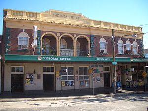
Lakemba, New South Wales
Suburb of City of Canterbury-Bankstown, New South Wales, Australia
Distance: Approx. 1150 meters
Latitude and longitude: -33.93166667,151.08527778
Lakemba () is a suburb in Western Sydney, in the state of New South Wales, Australia. Lakemba is located 12 kilometres south west of the Sydney central business district, in the local government area of the City of Canterbury-Bankstown.

Wiley Park railway station
Railway station in Sydney, New South Wales, Australia
Distance: Approx. 826 meters
Latitude and longitude: -33.923,151.0671
Wiley Park railway station is a heritage-listed railway station located on the Bankstown line, serving the Sydney suburb of Wiley Park. It was previously served by Sydney Trains T3 Bankstown line services and closed on 30 September 2024 as part of the Sydney Metro City & Southwest project where it will be converted to metro services.

Punchbowl railway station
Railway station in Sydney, New South Wales, Australia
Distance: Approx. 1689 meters
Latitude and longitude: -33.9254,151.0556
Punchbowl railway station is a heritage-listed railway station located on the Bankstown line, serving the Sydney suburb of Punchbowl. It was previously served by Sydney Trains T3 Bankstown line services and closed on 30 September 2024 as part of the Sydney Metro City & Southwest project where it will be converted to metro services.

Lakemba railway station
Railway station in Sydney, New South Wales
Distance: Approx. 912 meters
Latitude and longitude: -33.9201,151.0757
Lakemba railway station is a heritage-listed railway station located on the Bankstown line, serving the Sydney suburb of Lakemba. It was previously served by Sydney Trains T3 Bankstown line services and closed on 30 September 2024 as part of the Sydney Metro City & Southwest project where it will be converted to metro services.
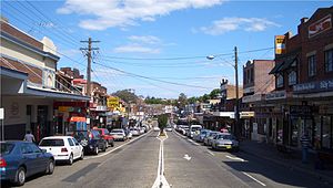
Wiley Park, New South Wales
Suburb of Sydney, New South Wales, Australia
Distance: Approx. 980 meters
Latitude and longitude: -33.92583333,151.06333333
Wiley Park is a suburb in south-western Sydney, in the state of New South Wales, Australia. Wiley Park is located 17 kilometres south-west of the Sydney central business district in the City of Canterbury-Bankstown.

Roselands, New South Wales
Suburb of Sydney, New South Wales, Australia
Distance: Approx. 1150 meters
Latitude and longitude: -33.93166667,151.08527778
Roselands is a suburb to the south-west of the Sydney CBD, in the state of New South Wales, Australia. Roselands is located 16 kilometres south-west of the Sydney central business district in the City of Canterbury-Bankstown. It is one of the easternmost suburbs in the Western Sydney area and is one of the major suburbs in Sydney without a train station.
Belmore, New South Wales
Suburb of Sydney, New South Wales, Australia
Distance: Approx. 1763 meters
Latitude and longitude: -33.9175,151.08777778
Belmore is a suburb of Sydney, in the state of New South Wales, Australia. Belmore is located 11 kilometres south-west of the Sydney central business district, in the local government area of the City of Canterbury-Bankstown.

Lakemba Mosque
Mosque in Australia
Distance: Approx. 1727 meters
Latitude and longitude: -33.912589,151.074074
The Lakemba Mosque, also known as the Masjid Ali Bin Abi Talib and officially the Imam Ali bin Abi Taleb Mosque, is Australia's largest mosque. It is located at 71-75 Wangee Road, Lakemba. Owned and managed by the Lebanese Muslim Association (LMA), Lakemba Mosque and the LMA offices are situated contiguously at the same address.
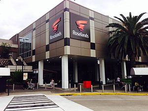
Roselands Shopping Centre
Shopping mall in Sydney, Australia
Distance: Approx. 882 meters
Latitude and longitude: -33.935,151.06888889
Roselands Shopping Centre (previously known as Centro Roselands) is a shopping centre in the suburb of Roselands in South Western Sydney.

Australian National Imams Council
Islamic organization based in Australia
Distance: Approx. 776 meters
Latitude and longitude: -33.922514,151.078617
The Australian National Imams Council (ANIC) was formed in 2006 during a meeting of more than 80 Sunni imams which had gathered to discuss the crisis created by comments made by Taj El-Din Hilaly. In 2011, they requested that the Darulfatwa-supported Muslim Community Radio Incorporated not have its licence renewed due to ties with Al-Ahbash and because of its promotion of "sectarian fringe views".
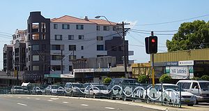
Wiley Park Girls High School
Public, girls, secondary school in Wiley Park, New South Wales, Australia
Distance: Approx. 762 meters
Latitude and longitude: -33.9241,151.0669
Wiley Park Girls High School, (abbreviation WPGHS) is a public girls' government high school located in the Sydney suburb of Wiley Park, New South Wales, Australia. It is the sister school of Belmore Boys High School. Established in 1957, it is operated by the New South Wales Department of Education with girls from years 7 to 12.
Punchbowl Mosque
Mosque in Sydney, Australia
Distance: Approx. 1499 meters
Latitude and longitude: -33.92718,151.0574
Punchbowl Mosque is a mosque located in the Sydney suburb of Punchbowl, in the state of New South Wales, Australia designed by Greek-Australian architect Angelo Candalepas. The building features a large central dome and 102 smaller concrete domes decorated with Islamic calligraphy depicting the 99 names of Allah. The mosque's use of exposed concrete has been likened to Brutalism, although some have pushed back against the distinction.
Weather in this IP's area
broken clouds
13 Celsius
13 Celsius
12 Celsius
14 Celsius
1023 hPa
84 %
1023 hPa
1017 hPa
10000 meters
4.63 m/s
330 degree
75 %
06:20:33
19:04:36