Country:
 Thailand
Region:
City:
Latitude and Longitude:
Time Zone:
Postal Code:
IP information under different IP Channel
ip-api
Country
Region
City
ASN
Time Zone
ISP
Blacklist
Proxy
Latitude
Longitude
Postal
Route
IPinfo
Country
Region
City
ASN
Time Zone
ISP
Blacklist
Proxy
Latitude
Longitude
Postal
Route
MaxMind
Country
Region
City
ASN
Time Zone
ISP
Blacklist
Proxy
Latitude
Longitude
Postal
Route
Luminati
Country
THRegion
73
City
samphran
ASN
Time Zone
Asia/Bangkok
ISP
TOT Public Company Limited
Latitude
Longitude
Postal
db-ip
Country
Region
City
ASN
Time Zone
ISP
Blacklist
Proxy
Latitude
Longitude
Postal
Route
ipdata
Country
Region
City
ASN
Time Zone
ISP
Blacklist
Proxy
Latitude
Longitude
Postal
Route
Popular places and events near this IP address

Sam Phran district
District in Nakhon Pathom, Thailand
Distance: Approx. 380 meters
Latitude and longitude: 13.72416667,100.21666667
Sam Phran (Thai: สามพราน, pronounced [sǎːm pʰrāːn]) is the southernmost district (amphoe) of Nakhon Pathom province, Thailand.

Nakhon Chai Si district
District in Nakhon Pathom, Thailand
Distance: Approx. 9454 meters
Latitude and longitude: 13.80111111,100.18777778
Nakhon Chai Si (Thai: นครชัยศรี, pronounced [ná(ʔ).kʰɔ̄ːn t͡ɕʰāj sǐː]) is a district (amphoe) of Nakhon Pathom province, central Thailand.

Krathum Baen district
District in Samut Sakhon, Thailand
Distance: Approx. 9032 meters
Latitude and longitude: 13.65583333,100.26777778
Krathum Baen (Thai: กระทุ่มแบน, pronounced [krā.tʰûm bɛ̄ːn]) is a district (amphoe) in the northern part of Samut Sakhon province, central Thailand.

Thai Human Imagery Museum
Wax museum in Thailand
Distance: Approx. 5796 meters
Latitude and longitude: 13.7728,100.208
The Thai Human Imagery Museum (Thai: พิพิธภัณฑ์หุ่นขี้ผึ้งไทย) is a wax museum located in Nakhon Pathom Province, Thailand. Due to the tropical climate of Thailand the figures are made of fibreglass instead of the traditional wax.
Joseph Upatham School
Private school in Sam Phran, Nakhon Pathom Province, Thailand
Distance: Approx. 4212 meters
Latitude and longitude: 13.721411,100.258246
Joseph Upatham School (Thai: โรงเรียนยอแซฟอุปถัมภ์), sometimes called "Joseph Upatham School Samphran" (Thai: โรงเรียนยอแซฟอุปถัมภ์ สามพราน) and abbreviated as JS (Thai: ยอ.)), is a private Catholic school in Nakhon Pathom, Thailand under the Education Department of the Archdiocese of Bangkok. Managed by the Archbishop and Pastor of the Archdiocese of Bangkok, the Sisters of the Sacred Heart of Jesus and the Sisters of Saint Paul of Chartres. Founder: Archbishop Joseph Khiamsun Nittayo Co-Founder: Rev.
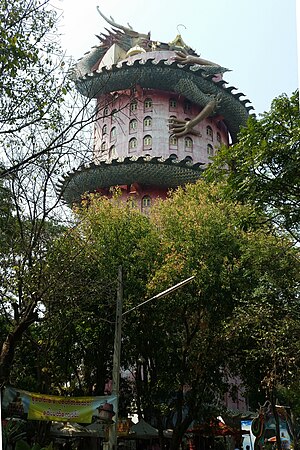
Wat Sam Phran
Buddhist temple
Distance: Approx. 1531 meters
Latitude and longitude: 13.735,100.215
Wat Sam Phran (Thai: วัดสามพราน, pronounced [wát sǎːm pʰrāːn]) is a Buddhist temple (wat) in Amphoe Sam Phran, Nakhon Pathom province, around 40 kilometers to the west of Bangkok. The temple was officially registered in 1985. In English, the wat is sometimes referred to as the "Dragon Temple".
Wat Tha Mai
Buddhist temple in Samut Sakhon province, Thailand
Distance: Approx. 6291 meters
Latitude and longitude: 13.676438,100.253847
Wat Tha Mai (Thai: วัดท่าไม้) is a Buddhist temple in Krathum Baen, Samut Sakhon, Thailand. It was known for sacred objects such as amulets and talismans. Many Thai celebrities visit this temple as part of their philanthropy and benefit from fortune telling by abbot Pra Ar Jan Uten Sirisaro.
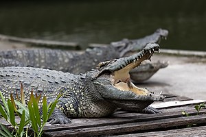
Samphran Elephant Ground & Zoo
Distance: Approx. 6541 meters
Latitude and longitude: 13.77016667,100.25380556
Samphran Elephant Ground & Zoo (Thai: ลานแสดงช้างและฟาร์มจระเข้สามพราน) is a famous tourist places suitable for all ages and located in Tha Kham, Sam Phran, Nakhon Pathom Province, central Thailand.

Wat Rai Khing
Distance: Approx. 4829 meters
Latitude and longitude: 13.7425,100.2586
Wat Rai Khing (Thai: วัดไร่ขิง, pronounced [wát râj kʰǐŋ]; lit. 'temple on ginger farm') is another prominent and notable temple in Nakhon Pathom province in addition to Wat Phra Pathom Chedi, which is the provincial temple. Wat Rai Khing is located along the Tha Chin River (known locally as Nakhon Chai Si River), Tambon Rai Khing, Sam Phran district on Petchkasem Road, west of Bangkok. And not far from other attractions such as Sampran Riverside (Rose Garden), Samphran Elephant Ground & Zoo etc.

Don Wai Market
Distance: Approx. 8923 meters
Latitude and longitude: 13.771732,100.283933
Don Wai Market (Thai: ตลาดน้ำวัดดอนหวาย, ตลาดน้ำดอนหวาย, lit. "(Wat) Don Wai Water Market", but sometimes translated as "floating market") Is a riverside market in Nakhon Pathom Province, Thailand. It is located along the Tha Chin River, behind Wat Don Wai in Bang Krathuek Subdistrict, Sam Phran District.

Wat Klang Bang Kaeo
Distance: Approx. 8652 meters
Latitude and longitude: 13.7953,100.193
Wat Klang Bang Kaeo is a temple in Nakhon Chai Si District, Central Thailand. Located on the Tha Chin River, the temple was established during the Ayutthaya period.
Don Kai Di
Distance: Approx. 9488 meters
Latitude and longitude: 13.643499,100.253707
Don Kai Di (Thai: ดอนไก่ดี, pronounced [dɔ̄ːn kàj dīː]) is a tambon (sub-district) in Krathum Baen District, Samut Sakhon Province, outskirts Bangkok.
Weather in this IP's area
light rain
28 Celsius
34 Celsius
28 Celsius
28 Celsius
1009 hPa
89 %
1009 hPa
1008 hPa
10000 meters
1.76 m/s
2.12 m/s
263 degree
94 %
06:09:18
18:01:33