Country:
Region:
City:
Latitude and Longitude:
Time Zone:
Postal Code:
IP information under different IP Channel
ip-api
Country
Region
City
ASN
Time Zone
ISP
Blacklist
Proxy
Latitude
Longitude
Postal
Route
Luminati
Country
Region
mi
ASN
Time Zone
America/Detroit
ISP
T-MOBILE-AS21928
Latitude
Longitude
Postal
IPinfo
Country
Region
City
ASN
Time Zone
ISP
Blacklist
Proxy
Latitude
Longitude
Postal
Route
db-ip
Country
Region
City
ASN
Time Zone
ISP
Blacklist
Proxy
Latitude
Longitude
Postal
Route
ipdata
Country
Region
City
ASN
Time Zone
ISP
Blacklist
Proxy
Latitude
Longitude
Postal
Route
Popular places and events near this IP address

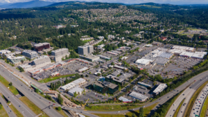
Factoria, Bellevue
Distance: Approx. 86 meters
Latitude and longitude: 47.57611111,-122.16888889
Factoria is a mixed-use suburban neighborhood in south Bellevue, Washington and is one of the city's significant commercial districts. Originally timberland from the 1890s to 1920s and later envisioned as an industrial center, Factoria has since the 1960s evolved into commercial and residential development. Factoria was annexed into Bellevue in 1993.

KIXI
Adult standards/oldies radio station in Mercer Island/Seattle, Washington
Distance: Approx. 1219 meters
Latitude and longitude: 47.58305556,-122.18111111
KIXI (880 AM) is a radio station licensed to Mercer Island/Seattle, Washington. It operates 24 hours a day with a daytime power of 50,000 watts and a nighttime power of 10,000 watts from a transmitter in Mercer Slough Nature Park in Bellevue, where studios are also located (although in a separate location).
Bellevue College
Community college in Bellevue, Washington, US
Distance: Approx. 1685 meters
Latitude and longitude: 47.584964,-122.149304
Bellevue College (BC) is a public college in Bellevue, Washington. Created in 1966, the school is the largest of the 34 institutions that make up the Washington Community and Technical Colleges (SBCTC) system and the third-largest institution of higher education in the state (behind the University of Washington and Washington State University).
Newport High School (Bellevue, Washington)
Public, coeducational school in Bellevue, Washington, United States
Distance: Approx. 996 meters
Latitude and longitude: 47.56805556,-122.17194444
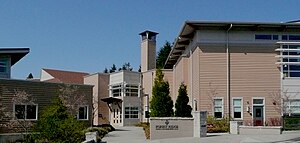
Newport High School (NHS) is a public high school in Bellevue, Washington. It serves students in grades 9–12 in the southern part of the Bellevue School District, including the neighborhoods of Eastgate, Factoria, Newport Hills, Newport Shores, Somerset, The Summit, and Sunset. As of the 2022–23 school year, the principal is Dion Yahoudy.
KXPA
American radio station in Bellevue, Washington
Distance: Approx. 1962 meters
Latitude and longitude: 47.59138889,-122.18222222
KXPA (1540 kHz) is a commercial AM radio station licensed to Bellevue, Washington, United States, serving the Seattle metropolitan area. It is part of the nationwide Multicultural Radio Broadcasting network, one of 30 stations owned by Arthur Liu, which cater to minority and immigrant communities with programs in their native languages. The transmitter is located off 118th Avenue SE in Bellevue, near Kelsey Creek.
KKNW
Talk radio station in Seattle
Distance: Approx. 1759 meters
Latitude and longitude: 47.58638889,-122.18638889
KKNW (1150 AM) is a commercial radio station licensed to serve Seattle, Washington. The station is owned by Hubbard Broadcasting, Inc., and features a talk radio format. KKNW mostly airs call-in and discussion shows where the host pays the station for the air time, known in the radio industry as "brokered time".

Forest Ridge School of the Sacred Heart
Private, girls school in Bellevue, Washington, US
Distance: Approx. 2191 meters
Latitude and longitude: 47.55888889,-122.15527778
Forest Ridge School of the Sacred Heart is a private, Roman Catholic, all-girls middle school and high school in Bellevue, Washington, United States, with a student population of around 260. The school is a member of the Society of the Sacred Heart schools and is part of the global Network of Sacred Heart Schools. Forest Ridge educates girls in grades 5 through 12.
BizX
Distance: Approx. 1076 meters
Latitude and longitude: 47.57863889,-122.154
BizX is an American financial technology company that operates a digital private currency (the BizX dollar) that facilitates business-to-business exchange of goods and services. The company is headquartered in Seattle, Washington, with offices in Oakland, California and Dubai, United Arab Emirates. BizX was founded in 2002 by Bob Bagga, Chris Haddawy, and Raj Kapoor.

South Bellevue station
Light rail station in Bellevue, Washington
Distance: Approx. 1996 meters
Latitude and longitude: 47.58638889,-122.19027778
South Bellevue station is an elevated light rail station located in Bellevue, Washington, United States, an eastern suburb of Seattle. It opened on April 27, 2024, as the western terminus of the 2 Line of Sound Transit's Link light rail system. The station has a park and ride garage with 1,500 stalls and bus service from King County Metro and Sound Transit Express.

Music Works Northwest
Distance: Approx. 1481 meters
Latitude and longitude: 47.58055556,-122.14916667
Music Works Northwest is the non-profit community music school located in Bellevue, Washington, USA. Music Works Northwest is one of the largest non-profit community music schools in the Pacific Northwest. It is a member of the Washington Music Educators Association, the Eastside Arts Coalition, and the Bellevue Arts Commission. The school also has partnerships with Northwest Pianos, 4Culture of King County, United Way of King County, the Bellevue Youth Symphony Orchestra, and the Boys & Girls Clubs of King County.
Bellevue murders
1997 mass murder in Bellevue, Washington
Distance: Approx. 1902 meters
Latitude and longitude: 47.5932,-122.174
The Bellevue murders, also known as the Bellevue massacre, occurred on the night of January 3, and the early morning of January 4, 1997. Alex Kevin Baranyi and David Carpenter Anderson, both 17 years old, lured Kimberly Ann Wilson, 20, to a park in Bellevue, Washington, US, and murdered her. Afterwards, they entered her family home and murdered her father Bill Wilson, his wife, Rose Wilson, and their other daughter, Julia Wilson.

Bannerwood Park
Baseball park in Bellevue, Washington, US
Distance: Approx. 2192 meters
Latitude and longitude: 47.596,-122.163
Bannerwood Park is a baseball park in the northwest United States, located in Bellevue, Washington, a suburb east of Seattle. It is the home field of Seattle University, a member of the NCAA Division I Western Athletic Conference. The venue features lighting, bleacher seating, concessions, and restrooms.
Weather in this IP's area
light rain
5 Celsius
1 Celsius
4 Celsius
6 Celsius
1006 hPa
87 %
1006 hPa
998 hPa
10000 meters
7.15 m/s
11.18 m/s
212 degree
100 %
07:17:44
16:30:06