1.179.48.183 - IP Lookup: Free IP Address Lookup, Postal Code Lookup, IP Location Lookup, IP ASN, Public IP
Country:
Region:
City:
Location:
Time Zone:
Postal Code:
IP information under different IP Channel
ip-api
Country
Region
City
ASN
Time Zone
ISP
Blacklist
Proxy
Latitude
Longitude
Postal
Route
Luminati
Country
Region
nsw
City
sydney
ASN
Time Zone
Australia/Sydney
ISP
iseek Communications Pty Ltd
Latitude
Longitude
Postal
IPinfo
Country
Region
City
ASN
Time Zone
ISP
Blacklist
Proxy
Latitude
Longitude
Postal
Route
IP2Location
1.179.48.183Country
Region
queensland
City
woolloongabba
Time Zone
Australia/Brisbane
ISP
Language
User-Agent
Latitude
Longitude
Postal
db-ip
Country
Region
City
ASN
Time Zone
ISP
Blacklist
Proxy
Latitude
Longitude
Postal
Route
ipdata
Country
Region
City
ASN
Time Zone
ISP
Blacklist
Proxy
Latitude
Longitude
Postal
Route
Popular places and events near this IP address

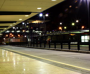
Woolloongabba busway station
Public transport station in Australia
Distance: Approx. 281 meters
Latitude and longitude: -27.48611111,153.03480556
Woolloongabba busway station is located in Brisbane, Australia serving the suburb of Woolloongabba. It opened on 13 September 2000 when the first section of the South East Busway opened from Melbourne Street, South Brisbane to coincide with the start of the 2000 Olympic football tournament, for which some matches were held in Brisbane. It initially opened for outbound services only, with inbound services commencing on 23 October 2000.
2009 Brisbane Lions season
Australian rules football club season
Distance: Approx. 350 meters
Latitude and longitude: -27.48583333,153.03805556
This article covers the 2009 AFL season results for AFL team, the Brisbane Lions.
2008 Brisbane Lions season
Brisbane Lions 2008 football season
Distance: Approx. 350 meters
Latitude and longitude: -27.48583333,153.03805556
This article covers the 2008 AFL season results for the Brisbane Lions.
2010 Brisbane Lions season
Australian rules football club season
Distance: Approx. 350 meters
Latitude and longitude: -27.48583333,153.03805556
This covers all the results and statistics for the Brisbane Lions in the 2010 AFL season.
2011 Brisbane Lions season
Australian rules football club season
Distance: Approx. 350 meters
Latitude and longitude: -27.48583333,153.03805556
The 2011 season was the Brisbane Lions' 15th season in the Australian Football League. The club also participated in the pre-season NAB Cup and, after getting knocked out in the first round, the NAB Challenge. The club finished 15th in the regular season, recording only 4 wins, their worst result since 1998.
Woolloongabba Post Office
Historic site in Queensland, Australia
Distance: Approx. 283 meters
Latitude and longitude: -27.4865,153.0341
Woolloongaba Post Office is a heritage-listed former post office at 765 Stanley Street, Woolloongabba, City of Brisbane, Queensland, Australia. It was designed by Thomas Pye and built in 1905 by Thomas Rees. It is also known as Woolloongabba Post & Telegraph Office.

Broadway Hotel, Woolloongabba
Historic site in Queensland, Australia
Distance: Approx. 290 meters
Latitude and longitude: -27.4899,153.0384
Broadway Hotel is a heritage-listed hotel at 93 Logan Road, Woolloongabba, City of Brisbane, Queensland, Australia. It was designed by John Hall & Son and constructed from 1889 to c. 1942 by Wooley & Whyte. It was added to the Queensland Heritage Register on 21 October 1992.

Woolloongabba Police Station
Historic site in Queensland, Australia
Distance: Approx. 335 meters
Latitude and longitude: -27.4854,153.0362
Woolloongabba Police Station is a heritage-listed former police station at 842–848 Main Street, Woolloongabba, City of Brisbane, Queensland, Australia. It was designed by the Queensland Department of Public Works and built from 1913 to 1936. It is also known as South Coast District Headquarters and Woolloongabba Police Station.

Taylor–Heaslop Building
Historic site in Queensland, Australia
Distance: Approx. 181 meters
Latitude and longitude: -27.4869,153.0367
Taylor–Heaslop Building is a heritage-listed commercial building at 10–14 Logan Road, Woolloongabba, City of Brisbane, Queensland, Australia. It was designed by John Beauchamp Nicholson and built from 1889 to 1890. It is also known as Ernest Reid (draper), John Evan's Cash Draper, George Logan Draper, Johns & Co Draper, People's Cash Store (grocers), JR Blane (grocer & hardware merchant), and Moreton Rubber Works.
Woolloongabba Fiveways
Distance: Approx. 223 meters
Latitude and longitude: -27.4864,153.036
The Woolloongabba Fiveways is the intersection of 5 major roads at Woolloongabba, Brisbane, Queensland, Australia. The intersection gives its name to the surrounding commercial area.
2013 Brisbane Lions season
Brisbane Lions 2013 football season
Distance: Approx. 350 meters
Latitude and longitude: -27.48583333,153.03805556
This article covers the 2013 AFL season results for the Brisbane Lions.
2012 Brisbane Lions season
Brisbane Lions 2012 football season
Distance: Approx. 350 meters
Latitude and longitude: -27.48583333,153.03805556
This article covers the 2012 AFL season results for the Brisbane Lions.
Weather in this IP's area
broken clouds
29 Celsius
32 Celsius
27 Celsius
30 Celsius
1010 hPa
62 %
1010 hPa
1005 hPa
10000 meters
1.79 m/s
5.81 m/s
85 degree
64 %

