Country:
 Thailand
Region:
City:
Latitude and Longitude:
Time Zone:
Postal Code:
IP information under different IP Channel
ip-api
Country
Region
City
ASN
Time Zone
ISP
Blacklist
Proxy
Latitude
Longitude
Postal
Route
IPinfo
Country
Region
City
ASN
Time Zone
ISP
Blacklist
Proxy
Latitude
Longitude
Postal
Route
MaxMind
Country
Region
City
ASN
Time Zone
ISP
Blacklist
Proxy
Latitude
Longitude
Postal
Route
Luminati
Country
THRegion
73
City
nakhonpathom
ASN
Time Zone
Asia/Bangkok
ISP
TOT Public Company Limited
Latitude
Longitude
Postal
db-ip
Country
Region
City
ASN
Time Zone
ISP
Blacklist
Proxy
Latitude
Longitude
Postal
Route
ipdata
Country
Region
City
ASN
Time Zone
ISP
Blacklist
Proxy
Latitude
Longitude
Postal
Route
Popular places and events near this IP address

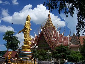
Nakhon Pathom province
Province of Thailand
Distance: Approx. 9833 meters
Latitude and longitude: 13.91666667,100.11666667
Nakhon Pathom (Thai: จังหวัดนครปฐม, pronounced [náʔkʰɔ̄ːn pā.tʰǒm], (Pronunciation)) is one of the central provinces (changwat) of Thailand. Neighbouring provinces are (from north clockwise) Suphan Buri, Ayutthaya, Nonthaburi, Bangkok, Samut Sakhon, Ratchaburi, and Kanchanaburi. The capital city of Nakhon Pathom province is Nakhon Pathom.

Nakhon Chai Si district
District in Nakhon Pathom, Thailand
Distance: Approx. 7314 meters
Latitude and longitude: 13.80111111,100.18777778
Nakhon Chai Si (Thai: นครชัยศรี, pronounced [ná(ʔ).kʰɔ̄ːn t͡ɕʰāj sǐː]) is a district (amphoe) of Nakhon Pathom province, central Thailand.
Wat Bang Phra
Distance: Approx. 4115 meters
Latitude and longitude: 13.8976,100.2126
Wat Bang Phra (Thai: วัดบางพระ) is a Buddhist monastery (wat) in Nakhon Chaisi district, Nakhon Pathom Province, Thailand, about 50 km west of Bangkok. Wat Bang Phra translates into English as the "Monastery of the Riverbank Buddha Image," a reference to the temple's history as a spot where a revered Buddha image from Ayuthaya was recovered from a boat which sank in the Nakhon Chaisi River alongside where the monastery was founded.
Thailand Circuit
Distance: Approx. 5647 meters
Latitude and longitude: 13.91184444,100.16786944
Nakhonchaisri Motor Sport Complex (Thailand Circuit) was established in 1989 aiming for Motorsports Entertainment in Thailand. Thongchai Wongsawan, President and Founder of Thailand Circuit's has had a passion and faith in Motorsport since his childhood and he became a Motorsports Connoisseur in 1978 by developing a small partnership to organise Motosports and today his firm has become the leading one in Motorsport, Media & Music Marketing in Thailand as well as International Criteria. To celebrate the 30th Anniversary of FM:T Thailand Road Racing and Top Gear Group in 2008, Thailand Circuit, Motorsports Complex made another move and renovation of Motorsports Facilities to support Motorcycles, Cars Manufactures and Automotive Industrial Business firms.
Suan Sunandha Rajabhat University Salaya Campus Stadium
Distance: Approx. 8506 meters
Latitude and longitude: 13.867954,100.270395
Suan Sunandha Rajabhat University Salaya Campus Stadium (Thai: สนาม มรภ.สวนสุนันทา ศาลายา) is a multi-purpose stadium in Nakhon Pathom Province, Thailand. The stadium holds 3,000 people.
Khlong Maha Sawat railway halt
Railway stop in Maha Sawat, Thailand
Distance: Approx. 9801 meters
Latitude and longitude: 13.8077,100.259
Khlong Maha Sawat Railway Halt is a railway halt in Maha Sawat Subdistrict, Phutthamonthon District, Nakhon Pathom. It is 27.053 km (16.8 mi) from Thon Buri railway station.

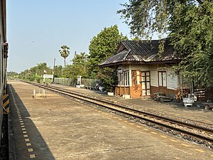
Wat Ngiu Rai railway station
Railway station in Ngio Rai, Thailand
Distance: Approx. 7063 meters
Latitude and longitude: 13.8078,100.216
Wat Ngiu Rai railway station is a railway station located in Ngiu Rai Subdistrict, Nakhon Chai Si District, Nakhon Pathom. It is a class 2 railway station located 30.8 km (19.1 mi) from Thon Buri railway station.
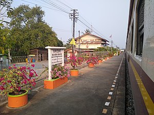
Nakhon Chai Si railway station
Rail station in Thailand
Distance: Approx. 6924 meters
Latitude and longitude: 13.8064,100.176
Nakhon Chai Si railway station is a railway station located in Wat Khae Subdistrict, Nakhon Chai Si District, Nakhon Pathom, Thailand. It is a class 2 railway station located 35.134 km (21.8 mi) from Thon Buri railway station.

Tha Chalaep railway station
Railway station in Thammasala, Thailand
Distance: Approx. 8849 meters
Latitude and longitude: 13.8123,100.132
Tha Chalaep railway station is a railway station located in Sisa Thong Subdistrict, Nakhon Chai Si District, Nakhon Pathom. It is a class 3 railway station located 40.025 km (24.9 mi) from Thon Buri railway station.

Wat Klang Bang Kaeo
Distance: Approx. 7949 meters
Latitude and longitude: 13.7953,100.193
Wat Klang Bang Kaeo is a temple in Nakhon Chai Si District, Central Thailand. Located on the Tha Chin River, the temple was established during the Ayutthaya period.
Weather in this IP's area
light rain
29 Celsius
36 Celsius
29 Celsius
29 Celsius
1003 hPa
90 %
1003 hPa
1003 hPa
10000 meters
2.6 m/s
4.88 m/s
222 degree
100 %
06:08:16
18:17:09