Country:
Region:
City:
Latitude and Longitude:
Time Zone:
Postal Code:
IP information under different IP Channel
ip-api
Country
Region
City
ASN
Time Zone
ISP
Blacklist
Proxy
Latitude
Longitude
Postal
Route
Luminati
Country
Region
73
City
nakhonpathom
ASN
Time Zone
Asia/Bangkok
ISP
TOT Public Company Limited
Latitude
Longitude
Postal
IPinfo
Country
Region
City
ASN
Time Zone
ISP
Blacklist
Proxy
Latitude
Longitude
Postal
Route
db-ip
Country
Region
City
ASN
Time Zone
ISP
Blacklist
Proxy
Latitude
Longitude
Postal
Route
ipdata
Country
Region
City
ASN
Time Zone
ISP
Blacklist
Proxy
Latitude
Longitude
Postal
Route
Popular places and events near this IP address

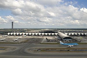
Suvarnabhumi Airport
Main airport serving Bangkok, Thailand
Distance: Approx. 5035 meters
Latitude and longitude: 13.6925,100.75
Suvarnabhumi Airport (IATA: BKK, ICAO: VTBS) is the main international airport serving Bangkok, the capital of Thailand. Located mostly in Racha Thewa subdistrict, Bang Phli district, Samut Prakan province, it covers an area of 3,240 ha (32.4 km2; 8,000 acres), making it one of the biggest international airports in Southeast Asia and a regional hub for aviation. The airport is also a major Cargo Air Freight Hub (20th busiest in 2019), which has a designated Airport Free Zone, as well as road links to the Eastern Economic Corridor (EEC) on Motorway 7.

King Mongkut's Institute of Technology Ladkrabang
University in Bangkok, Thailand
Distance: Approx. 559 meters
Latitude and longitude: 13.726725,100.780125
King Mongkut's Institute of Technology Ladkrabang (KMITL or KMIT Ladkrabang for short) is a research and educational institution in Thailand. It is situated in Lat Krabang District, Bangkok approximately 30 km east of the city center. The university consists of nine faculties: engineering, architecture, science, industrial education and technology, agricultural technology, information technology, food industry, liberal arts, and medicine.

Lat Krabang district
Khet in Bangkok, Thailand
Distance: Approx. 2634 meters
Latitude and longitude: 13.72231667,100.75966944
Lat Krabang (Thai: ลาดกระบัง, pronounced [lâːt krā.bāŋ]) is one of the eastern districts of Bangkok.
Protpittayapayat School
School in Bangkok, Thailand
Distance: Approx. 349 meters
Latitude and longitude: 13.7265,100.7845
The Protpittayapayat School is a public high school in Bangkok, Thailand.

Lad Krabang 54 Stadium
Football stadium in Thailand
Distance: Approx. 1912 meters
Latitude and longitude: 13.706226,100.783876
Lad Krabang 54 Stadium or Customs Department Stadium (Thai: สนามลาดกระบัง 54) หรือ (Thai: สนามกีฬากรมศุลกากร) is a football stadium in Bang Phli, Samut Prakan, Thailand. It used as the home ground of Customs United F.C. and Samut Prakan F.C. The stadium has a total capacity of 2,000. The main stand has a capacity of 1,500 and the away stand has a capacity of 500.

Suvarnabhumi station
Rapid transit station on the Airport Rail Link, serving Suvarnabhumi Airport in Thailand
Distance: Approx. 4819 meters
Latitude and longitude: 13.6942,100.7511
Suvarnabhumi Station (Thai: สถานีสุวรรณภูมิ, RTGS: Sathani Suwannaphum) is a rapid transit station on the Airport Rail Link. It serves the Suvarnabhumi Airport, Thailand, and is integrated with the passenger terminal. The station was opened in August 2010.
Hua Takhe railway station
Railway station in Thailand
Distance: Approx. 558 meters
Latitude and longitude: 13.7281,100.7822
Hua Takhe railway station is a railway station located in Lat Krabang Subdistrict, Lat Krabang District, Bangkok. It is a class 1 railway station located 30.911 km (19.2 mi) from Bangkok railway station. This station is the nearest station to Suvarnabhumi Airport, as well as the nearest large railway station to King Mongkut's Institute of Technology Ladkrabang.
Faculty of Medicine, King Mongkut's Institute of Technology Ladkrabang
Distance: Approx. 1240 meters
Latitude and longitude: 13.731061,100.775674
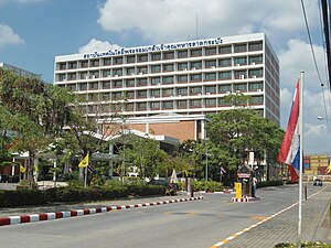
The Faculty of Medicine, King Mongkut's Institute of Technology Ladkrabang (Thai: คณะแพทยศาสตร์ สถาบันเทคโนโลยีพระจอมเกล้าเจ้าคุณทหารลาดกระบัง) is a medical school in Lat Krabang District, Bangkok.

Hua Takhe
Community and marketplace in Thailand
Distance: Approx. 530 meters
Latitude and longitude: 13.72447222,100.78877778
Hua Takhe (Thai: หัวตะเข้, pronounced [hǔa̯ tā.kʰêː]) is a community and marketplace in Lat Krabang District, and the name of the surrounding its location in eastern Bangkok. It is located on the tripoint between Thap Yao, Lat Krabang and Lam Pla Thio Subdistricts Hua Takhe is in an old community along the Khlong Prawet Burirom, where is a confluence of three khlongs (canals) Prawet Burirom, Lam Pla Thio, and Hua Takhe. Its name meaning "crocodile's head".

Phra Chom Klao railway halt
Railway stop in Lat Krabang, Thailand
Distance: Approx. 1005 meters
Latitude and longitude: 13.728,100.776
Phra Chom Klao Railway Halt (Thai: ป้ายหยุดรถไฟพระจอมเกล้า) is a railway halt of the eastern railway line located in the campus of King Mongkut's Institute of Technology Ladkrabang (KMITL), Lat Krabang Subdistrict, Lat Krabang District, eastern Bangkok. It is 30.33km (18 mi) from Hua Lamphong (Bangkok railway station) and is 830m (2,723 ft) away from the next station, Hua Takhe. The halt bisects a university and a Faculty of Engineering.

Lat Krabang subdistrict
Khwaeng in Thailand
Distance: Approx. 3552 meters
Latitude and longitude: 13.715953,100.752059
Lat Krabang (Thai: ลาดกระบัง, pronounced [lâːt krā.bāŋ]) is a khwaeng (subdistrict) of Lat Krabang District, in Bangkok, Thailand. In 2019, it had a total population of 30,353 people.

CMKL University
Higher Education and Research Institution
Distance: Approx. 1193 meters
Latitude and longitude: 13.7275957,100.7738506
CMKL University (CMKL, Thai: มหาวิทยาลัยซีเอ็มเคแอล) is a joint collaboration between Carnegie Mellon University and King Mongkut's Institute of Technology Ladkrabang a leading engineering university in Thailand, for the dual-degree graduate programs in Electrical & Computer Engineering (ECE).
Weather in this IP's area
moderate rain
31 Celsius
35 Celsius
30 Celsius
32 Celsius
1010 hPa
62 %
1010 hPa
1009 hPa
10000 meters
4.12 m/s
60 degree
20 %
06:12:39
17:48:14
