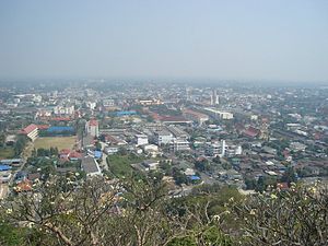
Country:
Region:
City:
Latitude and Longitude:
Time Zone:
Postal Code:
IP information under different IP Channel
ip-api
Country
Region
City
ASN
Time Zone
ISP
Blacklist
Proxy
Latitude
Longitude
Postal
Route
Luminati
Country
Region
73
City
nakhonpathom
ASN
Time Zone
Asia/Bangkok
ISP
TOT Public Company Limited
Latitude
Longitude
Postal
IPinfo
Country
Region
City
ASN
Time Zone
ISP
Blacklist
Proxy
Latitude
Longitude
Postal
Route
db-ip
Country
Region
City
ASN
Time Zone
ISP
Blacklist
Proxy
Latitude
Longitude
Postal
Route
ipdata
Country
Region
City
ASN
Time Zone
ISP
Blacklist
Proxy
Latitude
Longitude
Postal
Route
Popular places and events near this IP address

Phetchaburi province
Province of Thailand
Distance: Approx. 695 meters
Latitude and longitude: 13.11055556,99.94638889
Phetchaburi (Thai: เพชรบุรี, pronounced [pʰét.tɕʰā.bū.rīː]) or Phet Buri (pronounced [pʰét bū.rīː]) is one of the western or central provinces (changwat) of Thailand. Neighboring provinces are (from north clockwise) Ratchaburi, Samut Songkhram, and Prachuap Khiri Khan. In the west it borders the Tanintharyi Division of Myanmar.
Phetchaburi
Town in Phetchaburi Province, Thailand
Distance: Approx. 822 meters
Latitude and longitude: 13.11194444,99.94583333
Phetchaburi (Thai: เพชรบุรี, pronounced [pʰét.t͡ɕʰā.bū.rīː]) or Phet Buri (pronounced [pʰét bū.rīː]) is a town (thesaban mueang) in southern Thailand, capital of Phetchaburi Province. In Thai, Phetchaburi means "city of diamonds" (buri meaning "city" in Sanskrit). It is approximately 160 km south of Bangkok, at the northern end of the Thai peninsula.
Phra Nakhon Khiri Historical Park
Historical park on a hill in Thailand
Distance: Approx. 923 meters
Latitude and longitude: 13.1089,99.9365
Phra Nakhon Khiri (Thai: อุทยานประวัติศาสตร์พระนครคีรี) is a historical park in Phetchaburi, Thailand on a hill overlooking the city. The name Phra Nakhon Khiri means 'holy city hill', but locals know it better as Khao Wang, meaning 'hill with palace'. The park consists of three building groups on the three peaks of the 95 m hill.

Mueang Phetchaburi district
District in Phetchaburi, Thailand
Distance: Approx. 795 meters
Latitude and longitude: 13.11194444,99.94388889
Mueang Phetchaburi (Thai: เมืองเพชรบุรี, pronounced [mɯ̄aŋ pʰét.tɕʰā.bū.rīː]) is the capital district (amphoe mueang) of Phetchaburi province, western Thailand.
Phetchaburi railway station
Railway station in Thailand
Distance: Approx. 1276 meters
Latitude and longitude: 13.116,99.9414
Phetchaburi railway station is a railway station located in Khlong Krachaeng Subdistrict, Phetchaburi City. It is a class 1 railway station.
Phetchaburi Province Stadium
Multi-purpose stadium in Phetchaburi, Thailand
Distance: Approx. 2399 meters
Latitude and longitude: 13.125031,99.936277
Phetchaburi Province Stadium (Thai: สนามกีฬาจังหวัดเพชรบุรี) is a multi-purpose stadium in Phetchaburi Province, Thailand. It is currently used mostly for football matches and is the home stadium of Phetchaburi F.C. The stadium holds 3,500 people.
Prommanusorn Phetchaburi School
Distance: Approx. 642 meters
Latitude and longitude: 13.1043,99.938
Prommanusorn Phetchaburi School (abbreviated "PB") is located in Thailand. It is located on 278 Bandaiit Road, Moung, Phetchaburi. It consists of two level of education, lower secondary education and higher secondary education, in a coeducational system.
Benchamatheputhit School
Public school (government funded) school in Mueang Phetchaburi District, Phetchaburi, Thailand
Distance: Approx. 1210 meters
Latitude and longitude: 13.114436,99.938743
Benchamatheputhit School (BMP) (Thai:โรงเรียนเบญจมเทพอุทิศ) is a high school in Phetchaburi Province, Thailand. It is a large secondary school that receives co-education students and open from grade 7 to grade 12.
Samo Phlue
Subdistrict in Thailand
Distance: Approx. 4950 meters
Latitude and longitude: 13.06180556,99.95555556
Samo Phlue (Thai: สมอพลือ, pronounced [sā.mɔ̌ː pʰlɯ̄ː]) is a tambon (sub-district) of Ban Lat District, Phetchaburi Province, western Thailand.
Khlong Krachaeng
Distance: Approx. 704 meters
Latitude and longitude: 13.111116,99.943632
Khlong Krachaeng is a tambon (subdistrict) and neighbourhood in Mueang Phetchaburi District, Phetchaburi Province, Thailand.
Wat Phlapphla Chai, Phetchaburi
Distance: Approx. 501 meters
Latitude and longitude: 13.10709967,99.9478745
Wat Phlapphla Chai (Thai: วัดพลับพลาชัย; pronounced [wát pʰláp.pʰlāː t͡ɕʰāj]) is an ancient Buddhist temple in Mueang Phetchaburi District, Phetchaburi Province, western Thailand.

Wat Khao Bandai It
Distance: Approx. 1075 meters
Latitude and longitude: 13.09773,99.95066
Wat Khao Bandai It is an ancient temple사원 in Phetchaburi province펫차부리 주, western Thailand. It is one of the most famous temples in Phetchaburi, with its history dating back to the Sukhothai수코타이 or Ayutthaya periods아유타야 시대. The temple is located within the "Khao Bandai It" (temple of brick stair mountain) area, southwest of Phra Nakhon KhiriPhra Nakhon Khiri (also known as Khao Wang).
Weather in this IP's area
light rain
26 Celsius
27 Celsius
26 Celsius
26 Celsius
1010 hPa
86 %
1010 hPa
1009 hPa
10000 meters
1.54 m/s
2.03 m/s
318 degree
100 %
06:15:17
17:52:19


