Country:
 Thailand
Region:
City:
Latitude and Longitude:
Time Zone:
Postal Code:
IP information under different IP Channel
ip-api
Country
Region
City
ASN
Time Zone
ISP
Blacklist
Proxy
Latitude
Longitude
Postal
Route
IPinfo
Country
Region
City
ASN
Time Zone
ISP
Blacklist
Proxy
Latitude
Longitude
Postal
Route
MaxMind
Country
Region
City
ASN
Time Zone
ISP
Blacklist
Proxy
Latitude
Longitude
Postal
Route
Luminati
Country
THRegion
10
City
bangkok
ASN
Time Zone
Asia/Bangkok
ISP
TOT Public Company Limited
Latitude
Longitude
Postal
db-ip
Country
Region
City
ASN
Time Zone
ISP
Blacklist
Proxy
Latitude
Longitude
Postal
Route
ipdata
Country
Region
City
ASN
Time Zone
ISP
Blacklist
Proxy
Latitude
Longitude
Postal
Route
Popular places and events near this IP address

Bangkok Noi district
Khet in Bangkok, Thailand
Distance: Approx. 1669 meters
Latitude and longitude: 13.77086667,100.46793333
Bangkok Noi (Thai: บางกอกน้อย, pronounced [bāːŋ.kɔ̀ːk nɔ́ːj]) is one of the 50 districts (khet) of Bangkok, Thailand. Neighboring districts are (from north clockwise) Bang Phlat, Phra Nakhon (across Chao Phraya River), Bangkok Yai, Phasi Charoen, and Taling Chan.

Taling Chan district
Khet in Bangkok, Thailand
Distance: Approx. 1338 meters
Latitude and longitude: 13.77694444,100.45666667
Taling Chan (Thai: ตลิ่งชัน, pronounced [tā.lìŋ tɕʰān]) is one of the 50 districts (khet) of Bangkok, Thailand. Its neighbours, clockwise from the north, are Bang Kruai district of Nonthaburi province and Bang Phlat, Bangkok Noi, Bangkok Yai, Phasi Charoen, Bang Khae, and Thawi Watthana Districts of Bangkok.

Bang Ramat railway halt
Railway halt in Bangkok, Thailand
Distance: Approx. 1470 meters
Latitude and longitude: 13.778509,100.453515
Bang Ramat railway halt (Thai: บางระมาด) is a railway halt located in Chimphli Subdistrict, Taling Chan District, Bangkok, Thailand. It is 4.29 km (2.7 mi) from Thon Buri railway station.

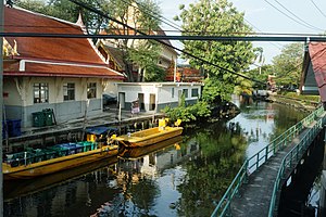
Khlong Bangkok Yai
Distance: Approx. 1853 meters
Latitude and longitude: 13.77925,100.46294444
Khlong Bangkok Yai (Thai: คลองบางกอกใหญ่, pronounced [kʰlɔ̄ːŋ bāːŋ.kɔ̀ːk jàj]; lit: 'Big Bangkok Canal') is a historic khlong (คลอง; canal) of Bangkok. The current length is 6 km (about 3 mi), through various canals as far as it terminates when it meets Khlong Mon near the confluence of three canals, Khlong Chak Phra, Khlong Mon and Khlong Bang Chueak Nang. In total, the canal passes through three districts, namely Bangkok Yai, Thon Buri and Phasi Charoen.

Bang Khun Non subdistrict
Khwaeng in Thailand
Distance: Approx. 1718 meters
Latitude and longitude: 13.77319444,100.46725
Bang Khun Non (Thai: บางขุนนนท์, pronounced [bāːŋ kʰǔn nōn]) is a khwaeng (subdistrict) of Bangkok Noi District, in Bangkok, Thailand. In 2018, it had a total population of 9,549 people.

Khlong Chak Phra
Canal in Bangkok, Thailand
Distance: Approx. 1359 meters
Latitude and longitude: 13.77685833,100.45765833
Khlong Chak Phra (Thai: คลองชักพระ, pronounced [kʰlɔ̄ːŋ t͡ɕʰák pʰráʔ]) is a khlong (canal) in Bangkok's Thonburi area. It separates from Khlong Bangkok Noi at front of Wat Suwan Keree and terminates at the confluence of khlongs Mon and Bangkok Yai. It serves as a demarcation line between Bangkok Noi and Taling Chan Districts all the length.

Khlong Chak Phra subdistrict
Sub-district in Bangkok, Thailand
Distance: Approx. 1303 meters
Latitude and longitude: 13.77665556,100.45653056
Khlong Chak Phra (Thai: คลองชักพระ, pronounced [kʰlɔ̄ːŋ t͡ɕʰák pʰráʔ]) is one of the six khwaengs (sub-districts) of Taling Chan District in Bangkok's Thonburi side. It is the location of the district office.
Bang Phrom subdistrict, Bangkok
Khwaeng in Thailand
Distance: Approx. 1937 meters
Latitude and longitude: 13.75222222,100.44177778
Bang Phrom (Thai: บางพรม, pronounced [bāːŋ pʰrōm]) is a khwaeng (subdistrict) of Taling Chan district, Bangkok's Thonburi side.

Charan Sanit Wong Road
Road in Bangkok, Thailand
Distance: Approx. 1965 meters
Latitude and longitude: 13.76057222,100.47110556
Charan Sanit Wong Road (Thai: ถนนจรัญสนิทวงศ์, pronounced [tʰā.nǒn t͡ɕā.rān sā.nìt wōŋ]) is a main road in Bangkok's Thonburi side (west bank of Chao Phraya River), it is named in honour of Luang Charan Sanit Wong (ML Charan Sanitwong), the former Permanent Secretary, Ministry of Transport. Its name has been misspelled as จรัลสนิทวงศ์ in Thai according to the 1999 Royal Institute Dictionary. Charan Sanit Wong Road runs through the three districts of Bangkok, namely Bangkok Yai, Bangkok Noi and Bang Phlat.

Fai Chai MRT station
Metro station in Bangkok, Thailand
Distance: Approx. 2006 meters
Latitude and longitude: 13.7557,100.4693
Fai Chai station (Thai: สถานีไฟฉาย), is an elevated railway station on MRT Blue Line in Bangkok, Thailand. The station opened on 23 December 2019. The station is one of the nine stations of phase 3 of MRT Blue Line.
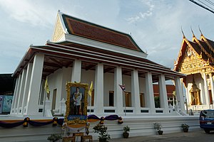
Wat Ratchada Thitthan
Distance: Approx. 745 meters
Latitude and longitude: 13.758611,100.453917
Wat Ratchada Thitthan Ratchaworawihan (Thai: วัดรัชฎาธิษฐานราชวรวิหาร) is a Thai Buddhist temple in Bangkok.
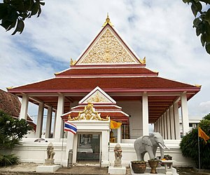
Wat Kanchana Singhat
Distance: Approx. 576 meters
Latitude and longitude: 13.760129,100.453883
Wat Kanchana Singhat Worawiharn (Thai: วัดกาญจนสิงหาสน์วรวิหาร) formerly and still colloquially known as Wat Thong (วัดทอง) or Wat Thong Bang Phrom (วัดทองบางพรม) is an ancient temple in Bangkok.
Weather in this IP's area
moderate rain
28 Celsius
33 Celsius
28 Celsius
28 Celsius
1002 hPa
88 %
1002 hPa
1001 hPa
10000 meters
1.86 m/s
4 m/s
278 degree
100 %
06:07:14
18:16:06