Country:
Region:
City:
Latitude and Longitude:
Time Zone:
Postal Code:
IP information under different IP Channel
ip-api
Country
Region
City
ASN
Time Zone
ISP
Blacklist
Proxy
Latitude
Longitude
Postal
Route
Luminati
Country
Region
vc
City
benicassim
ASN
Time Zone
Europe/Madrid
ISP
Orange Espagne SA
Latitude
Longitude
Postal
IPinfo
Country
Region
City
ASN
Time Zone
ISP
Blacklist
Proxy
Latitude
Longitude
Postal
Route
db-ip
Country
Region
City
ASN
Time Zone
ISP
Blacklist
Proxy
Latitude
Longitude
Postal
Route
ipdata
Country
Region
City
ASN
Time Zone
ISP
Blacklist
Proxy
Latitude
Longitude
Postal
Route
Popular places and events near this IP address
Festival Internacional de Benicàssim
Distance: Approx. 312 meters
Latitude and longitude: 40.0472,0.069444
The Festival Internacional de Benicàssim (Valencian pronunciation: [festiˈval inteɾnasi.oˈnal de beniˈkasim]), commonly abbreviated as FIB, is an annual music festival that takes place in the town of Benicàssim, in the Valencian Community, Spain. It focuses mainly on pop, rock, and electronica artists, as well as short films, fashion shows and art. The festival begins on the second Tuesday of July, which is when the camping grounds open - although music officially commences Thursday afternoon.

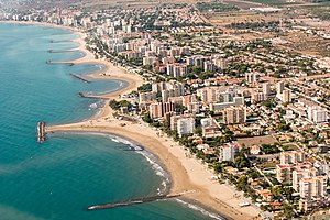
Benicàssim
Municipality in Valencian Community, Spain
Distance: Approx. 1290 meters
Latitude and longitude: 40.05527778,0.06416667
Benicàssim (Valencian: [beniˈkasim]; Spanish: Benicasim [benikaˈsin]); officially Benicasim / Benicàssim; Arabic: بنو قاسم, romanized: banū qāsim, or بني قاسم, banī qāsim, according to numismatic findings) is a municipality and beach resort located in the province of Castellón, on the Costa del Azahar in Spain. The Desert de les Palmes mountain range further inland shelters the town from the north wind. The name is derived from the Banu Qasim tribe, a segment of the Kutama Berbers that settled the area during the 8th century Arab conquest of Spain.

Plana Alta
Comarca in Valencian Community, Spain
Distance: Approx. 9269 meters
Latitude and longitude: 40.00657778,-0.02746389
Plana Alta (Valencian: [ˈplana ˈalta]; Spanish: [ˈplana ˈalta]) is a comarca in the province of Castellón in the Valencian Community, Spain. The largest town in the comarca is Castellón de la Plana, which is also the capital and largest town in the province.

Oropesa del Mar
Municipality in Valencian Community, Spain
Distance: Approx. 7650 meters
Latitude and longitude: 40.09222222,0.13388889
Oropesa del Mar (Valencian: Orpesa) is a municipality in the comarca of Plana Alta in the Valencian Community, Spain.
Desert de les Palmes Range
Mountain range in Spain
Distance: Approx. 5025 meters
Latitude and longitude: 40.08388889,0.04083333
Desert de les Palmes (Valencian pronunciation: [deˈzɛɾd de les ˈpalmes], Spanish: Desierto de las Palmas), also known as Serra del Desert de les Palmes is an 18.8 km long mountain range in the Plana Alta comarca, Valencian Community, Spain. Its highest point is Bartolo (729 m). The Ermita de La Magdalena 40°02′04″N 0°00′20″W, an important church for Castellonenc people, is located on a hill at the southern end of the range.

Castellón Aerodrome
Airport in km , WNW of Castellón de la Plana
Distance: Approx. 6263 meters
Latitude and longitude: 39.999,0.026
Castellón Airport (ICAO: LECN) is a small general aviation airport in Castelló de la Plana, on the mid-east coast of Spain, about 68 km (42 mi) north of Valencia.

Aquarama (water park)
Spanish water park
Distance: Approx. 1586 meters
Latitude and longitude: 40.04799,0.05139
Aquarama is a water park, located in Benicàssim, Castelló, Spain. The park has the eleventh-highest slide in the world named The Devil's Drop together with The Beast in Western Water Park.

Desert de les Palmes Natural Park
Nature preserve in Spain
Distance: Approx. 4921 meters
Latitude and longitude: 40.081,0.037
The Desert de les Palmes Nature Reserve (Spanish: Parque Natural del Desierto de Las Palmas, Valencian: Desert de les Palmes) is a nature preserve in the province of Castellón, in the Valencian Community, Spain.

Bartolo (peak)
Mountain in Spain
Distance: Approx. 5624 meters
Latitude and longitude: 40.08555556,0.03111111
Bartolo or Pic de Bartolo is the highest peak of the Desert de les Palmes range, Valencian Community, Spain. It reaches an elevation of 729 metres (2,392 ft) above sea level. There are antennas at the top.
Weather in this IP's area
scattered clouds
18 Celsius
18 Celsius
18 Celsius
18 Celsius
1022 hPa
78 %
1022 hPa
1022 hPa
10000 meters
1.22 m/s
1.24 m/s
350 degree
41 %
07:33:44
17:52:53
