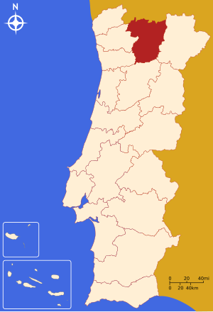
Country:
 Portugal
Region:
City:
Latitude and Longitude:
Time Zone:
Postal Code:
IP information under different IP Channel
ip-api
Country
Region
City
ASN
Time Zone
ISP
Blacklist
Proxy
Latitude
Longitude
Postal
Route
IPinfo
Country
Region
City
ASN
Time Zone
ISP
Blacklist
Proxy
Latitude
Longitude
Postal
Route
MaxMind
Country
Region
City
ASN
Time Zone
ISP
Blacklist
Proxy
Latitude
Longitude
Postal
Route
Luminati
Country
PTRegion
10
City
santarem
ASN
Time Zone
Europe/Lisbon
ISP
Servicos De Comunicacoes E Multimedia S.A.
Latitude
Longitude
Postal
db-ip
Country
Region
City
ASN
Time Zone
ISP
Blacklist
Proxy
Latitude
Longitude
Postal
Route
ipdata
Country
Region
City
ASN
Time Zone
ISP
Blacklist
Proxy
Latitude
Longitude
Postal
Route
Popular places and events near this IP address

University of Trás-os-Montes and Alto Douro
Public university in Vila Real, Portugal
Distance: Approx. 1534 meters
Latitude and longitude: 41.28738056,-7.73893889
The University of Trás-os-Montes and Alto Douro (UTAD; Portuguese: Universidade de Trás-os-Montes e Alto Douro) is a public university located in the north-eastern city of Vila Real, Portugal. It became a public university in 1986, although its history also includes a heritage received from its predecessor, the Polytechnic Institute of Vila Real, created in 1973. This Institute took on a relevant role in the development of the region, and in September 1979, it was converted into the University Institute of Trás-os-Montes and Alto Douro.

Trás-os-Montes e Alto Douro Province
Distance: Approx. 598 meters
Latitude and longitude: 41.29547111,-7.74626389
Trás-os-Montes e Alto Douro (Portuguese pronunciation: [ˌtɾaz uʒ ˈmõtɨz i ˈaltu ˈðoɾu]) is a historical province of Portugal located in the northeastern corner of the country, known for its scenery, which includes plateaux, river valleys, mountains, and castles.
Vila Real District
District of Portugal
Distance: Approx. 526 meters
Latitude and longitude: 41.29611111,-7.74611111
The District of Vila Real (Portuguese: Distrito de Vila Real [ˈvilɐ ʁiˈal] ) is a district of northern Portugal. With an area of 4,239 km2 (1,637 sq mi), the district is located east of the port city of Porto and north of the Douro River. Vila Real has always belonged to the historical province of Trás-os-Montes.

Douro (intermunicipal community)
Intermunicipal community in Norte, Portugal
Distance: Approx. 495 meters
Latitude and longitude: 41.3,-7.75
The Comunidade Intermunicipal do Douro (European Portuguese pronunciation: [ˈdoɾu]) is an administrative division in Portugal. It replaced the Comunidade Urbana do Douro, created in 2004. It takes its name from the Douro River.
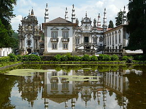
Mateus Palace
House in Vila Real, Portugal
Distance: Approx. 2676 meters
Latitude and longitude: 41.29694444,-7.7125
The Mateus Palace (Portuguese: Palácio de Mateus, Solar de Mateus or Casa de Mateus) is a palace located in the civil parish of Mateus, municipality of Vila Real, Portugal. The three primary buildings are the manor, the winery and the chapel. The winery buildings date from the 16th century and were modified in the 1800s.

Vila Real
Municipality in Norte, Portugal
Distance: Approx. 556 meters
Latitude and longitude: 41.29583333,-7.74611111
Vila Real (Portuguese pronunciation: [ˈvilɐ ʁiˈal] ) is the capital and largest city of the Vila Real District, in the North region, Portugal. It is also the seat of the Douro intermunicipal community and of the Trás-os-Montes e Alto Douro historical province. The Vila Real municipality covers an area of 378.80 square kilometres (146.26 sq mi) and is home to an estimated population of 49,574 (2021), of which about 30,000 live in the urban area (2021).
Cumieira
Civil parish in Norte, Portugal
Distance: Approx. 5421 meters
Latitude and longitude: 41.257,-7.773
Cumieira is a civil parish in the municipality of Santa Marta de Penaguião, Portugal. The population in 2011 was 1,146, in an area of 11.07 km2.

Cathedral of Vila Real
Distance: Approx. 521 meters
Latitude and longitude: 41.2963,-7.7466
The Cathedral of Vila Real (Portuguese: Sé de Vila Real), also known as the Church of St. Dominic (Portuguese: Igreja de São Domingos) is a Roman Catholic cathedral in Vila Real, Portugal. It is the seat of the Diocese of Vila Real.
Vila Real Airport
Airport in Vila Real, Portugal
Distance: Approx. 3283 meters
Latitude and longitude: 41.2775,-7.71972222
Vila Real Airport (IATA: VRL, ICAO: LPVR) is an airport located 4 km (2.5 mi) southeast of Vila Real, Portugal. As of May 2023, a new terminal building is being constructed. This will allow the fire service, police, customs and airclub to have space in a single building.

Vila Real Bridge
Bridge in Vila Real District
Distance: Approx. 2552 meters
Latitude and longitude: 41.2783,-7.7512
The Corgo Viaduct (Portuguese: Viaduto do Corgo) is a viaduct in Portugal. It is located in the Vila Real District, crossing the Corgo River. It is part of the A4 highway.
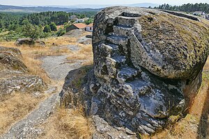
Panoias Sanctuary
Cultural heritage monument in Vila Real, Portugal
Distance: Approx. 5545 meters
Latitude and longitude: 41.28333333,-7.68194444
The Panóias Sanctuary, also called "Fragas de Panóias", is located in Vale de Nogueiras, in the municipality of Vila Real, Portugal, a few kilometres from the city
Botanical Garden of the University of Trás-os-Montes e Alto Douro
Botanic garden in Portugal
Distance: Approx. 1498 meters
Latitude and longitude: 41.2873,-7.7414
The Botanical Garden of University of Trás-os-Montes and Alto Douro (Portuguese: Jardim Botânico da Universidade de Trás-os-Montes e Alto Douro) is a botanical garden established in 1988. It is located within the campus of the University of Trás-os-Montes and Alto Douro (UTAD), in Vila Real, Portugal, and has an interpretive centre for visitors.
Weather in this IP's area
scattered clouds
19 Celsius
18 Celsius
19 Celsius
21 Celsius
1022 hPa
27 %
1022 hPa
971 hPa
10000 meters
1.1 m/s
2.09 m/s
228 degree
42 %
07:25:47
19:16:27