Country:
 Great Britain
Region:
City:
Latitude and Longitude:
Time Zone:
Postal Code:
IP information under different IP Channel
ip-api
Country
Region
City
ASN
Time Zone
ISP
Blacklist
Proxy
Latitude
Longitude
Postal
Route
IPinfo
Country
Region
City
ASN
Time Zone
ISP
Blacklist
Proxy
Latitude
Longitude
Postal
Route
MaxMind
Country
Region
City
ASN
Time Zone
ISP
Blacklist
Proxy
Latitude
Longitude
Postal
Route
Luminati
Country
GBRegion
eng
City
sevenoaks
ASN
Time Zone
Europe/London
ISP
EE Limited
Latitude
Longitude
Postal
db-ip
Country
Region
City
ASN
Time Zone
ISP
Blacklist
Proxy
Latitude
Longitude
Postal
Route
ipdata
Country
Region
City
ASN
Time Zone
ISP
Blacklist
Proxy
Latitude
Longitude
Postal
Route
Popular places and events near this IP address

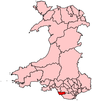
Bridgend
Town in South Wales
Distance: Approx. 145 meters
Latitude and longitude: 51.507,-3.578
Bridgend (English: ; Welsh: Pen-y-bont ar Ogwr or just Pen-y-bont, meaning "the end of the bridge on the Ogmore") is a town in the Bridgend County Borough of Wales, 20 miles (32 km) west of Cardiff and 20 miles (32 km) east of Swansea. The town is named after the medieval bridge over the River Ogmore. The River Ewenny also flows through the town.

Ogwr
Former district of Mid Glamorgan, Wales
Distance: Approx. 330 meters
Latitude and longitude: 51.5087,-3.5782
The Borough of Ogwr was one of six districts of Mid Glamorgan in Wales, which existed from 1974 to 1996.

Bridgend railway station
Railway station in Bridgend, Wales
Distance: Approx. 199 meters
Latitude and longitude: 51.50694444,-3.575
Bridgend railway station (Welsh: Gorsaf Pen-y-bont) is a main line station serving the town of Bridgend, south Wales. It is located approximately halfway between Cardiff Central and Swansea stations, at the point where the Maesteg Line diverges from the South Wales Main Line; it is also the western terminus of the Vale of Glamorgan Line from Cardiff. It is 190 miles 45 chains (306.7 km) measured from the zero point at London Paddington, via Stroud.

Brewery Field
Stadium in Bridgend, Wales
Distance: Approx. 561 meters
Latitude and longitude: 51.51,-3.58166667
Dunraven Brewery Field (Welsh: Cae'r Bragdy Dunraven) is an 8,000 (1,100 seated) capacity sports stadium in Bridgend, Wales. It is the home ground of the rugby union team Bridgend Ravens. Bridgend Athletic RFC often use the ground for their home matches, as well as the Ospreys who sometimes play at the ground, including their age grade teams.

Bridge FM (Wales)
Radio station in Bridgend
Distance: Approx. 498 meters
Latitude and longitude: 51.504665,-3.570254
Bridge FM is an Independent Local Radio station broadcasting to Bridgend County Borough and the surrounding areas. It is owned and operated by Nation Broadcasting and broadcasts on 106.3 FM from studios at the St Hilary transmitter in the Vale of Glamorgan. The station plays chart music from the 1980s to the present day, alongside local news, travel and community information.

Bridgend College
Further education college in Bridgend, Bridgend, Wales
Distance: Approx. 766 meters
Latitude and longitude: 51.4997,-3.5721
Bridgend College (Welsh: Coleg Penybont) is a further education college based in Bridgend, Wales. Founded in 1928 as the Bridgend Mining and Technical Institute, the college today has four campuses in Bridgend, Pencoed, Queens Road and Maesteg. The college currently delivers provision for over 6,000 students and employing over 700 members of staff across its four campuses.
Bridgend (Senedd constituency)
Constituency of the Senedd
Distance: Approx. 295 meters
Latitude and longitude: 51.507,-3.581
Bridgend (Welsh: Pen-y-bont ar Ogwr) is a constituency of the Senedd. It elects one Member of the Senedd by the first past the post method of election. Also, however, it is one of seven constituencies in the South Wales West electoral region, which elects four additional members, in addition to seven constituency members, to produce a degree of proportional representation for the region as a whole.

Newcastle Castle, Bridgend
Distance: Approx. 532 meters
Latitude and longitude: 51.50888889,-3.58305556
Newcastle Castle (Welsh: Y Castell Newydd) is a medieval castle located on Newcastle Hill, Newcastle, overlooking the town centre of Bridgend in Glamorgan, South Wales. It was originally believed to date from 1106 when a ringwork was created at the site by the Norman baron Robert Fitzhamon. Some of the fine stonework survives, but today the castle is ruinous.

Newcastle, Bridgend
Distance: Approx. 593 meters
Latitude and longitude: 51.508,-3.585
Newcastle is an area and electoral ward of the town of Bridgend, Wales. The area includes the medieval Newcastle Castle. The ward elects councillors to Bridgend Town Council and Bridgend County Borough Council.
Bridgend (community)
Human settlement in Wales
Distance: Approx. 367 meters
Latitude and longitude: 51.508663,-3.57457
Bridgend is a community in Bridgend County Borough, south Wales. Along with the communities of Brackla, Coychurch Lower and Laleston it makes up the town of Bridgend. Bridgend is the western district of Bridgend town, and takes in the town centre, Newcastle Hill, Tremains and to the north Wild Mill.
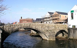
Old Bridge, Bridgend
Bridge in Bridgend, Wales
Distance: Approx. 248 meters
Latitude and longitude: 51.506789,-3.5804087
The Old Bridge (Welsh: Yr Hen Bont) is a medieval two arched stone footbridge that spans the River Ogmore at Bridgend in Wales. It is not known who designed or built the bridge, however it was built in approximately 1425. The bridge was repaired in 1775 and restored both in 2005 and 2011.
Oldcastle, Bridgend
Distance: Approx. 347 meters
Latitude and longitude: 51.503,-3.575
Oldcastle is an area and electoral ward of the town of Bridgend, Wales, to the south of the town centre. The ward elects councillors to Bridgend Town Council and Bridgend County Borough Council.
Weather in this IP's area
scattered clouds
20 Celsius
20 Celsius
19 Celsius
21 Celsius
1017 hPa
61 %
1017 hPa
1014 hPa
10000 meters
5.79 m/s
6.58 m/s
260 degree
28 %
05:31:04
21:10:19