Country:
 Great Britain
Region:
City:
Latitude and Longitude:
Time Zone:
Postal Code:
IP information under different IP Channel
ip-api
Country
Region
City
ASN
Time Zone
ISP
Blacklist
Proxy
Latitude
Longitude
Postal
Route
IPinfo
Country
Region
City
ASN
Time Zone
ISP
Blacklist
Proxy
Latitude
Longitude
Postal
Route
MaxMind
Country
Region
City
ASN
Time Zone
ISP
Blacklist
Proxy
Latitude
Longitude
Postal
Route
Luminati
Country
GBRegion
eng
City
littlehampton
ASN
Time Zone
Europe/London
ISP
EE Limited
Latitude
Longitude
Postal
db-ip
Country
Region
City
ASN
Time Zone
ISP
Blacklist
Proxy
Latitude
Longitude
Postal
Route
ipdata
Country
Region
City
ASN
Time Zone
ISP
Blacklist
Proxy
Latitude
Longitude
Postal
Route
Popular places and events near this IP address
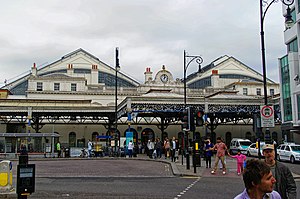
Brighton railway station
Railway station in Brighton, East Sussex, England
Distance: Approx. 121 meters
Latitude and longitude: 50.8288,-0.1411
Brighton railway station is the southern terminus of the Brighton Main Line, the western terminus of the East Coastway Line and the eastern terminus of the West Coastway Line in England, and the principal station serving the city of Brighton, East Sussex. It is 50 miles 49 chains (50.61 miles, 81.45 km) from London Bridge via Redhill. The station is managed by Govia Thameslink Railway, which operates all of the services.

Brighton railway works
Railway workshops in Brighton, Sussex, England
Distance: Approx. 399 meters
Latitude and longitude: 50.83194444,-0.13861111
Brighton railway works (also known as Brighton locomotive works, or just the Brighton works) was one of the earliest railway-owned locomotive repair works, founded in 1840 by the London and Brighton Railway in Brighton, England, and thus pre-dating the more famous railway works at Crewe, Doncaster and Swindon. The works grew steadily between 1841 and 1900 but efficient operation was always hampered by the restricted site, and there were several plans to close it and move the facility elsewhere. Nevertheless, between 1852 and 1957 more than 1200 steam locomotives as well as prototype diesel electric and electric locomotives were constructed there, before the eventual closure of the facility in 1962.

North Laine
Shopping and residential district in Brighton, England
Distance: Approx. 225 meters
Latitude and longitude: 50.82638889,-0.13916667
North Laine is a shopping and residential district of Brighton, on the English south coast. Once a slum area, it is now seen as Brighton's bohemian and cultural quarter, with many pubs, cafés, theatres and museums.

Brighton MET College
Further education college in Brighton
Distance: Approx. 191 meters
Latitude and longitude: 50.8292,-0.1371
Brighton MET is a large general further education college located in Brighton and Hove, It is now part of the Chichester College Group after Greater Brighton Metropolitan College merged with CCG on 1 August 2021. It has two campus: Central Brighton Campus, Pelham Street, Brighton and East Brighton Campus, Wilson Avenue, Brighton. It had previously been named City College Brighton & Hove, Brighton College of Technology, Brighton Technical College and Brighton College of Arts and Technology.
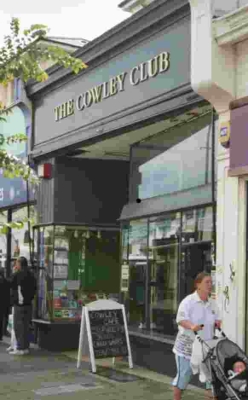
Cowley Club
Self-managed social centre in Brighton, England
Distance: Approx. 328 meters
Latitude and longitude: 50.83034722,-0.13599167
The Cowley Club is a libertarian self-managed social centre in Brighton, England. It opened in 2003, providing resources and meeting spaces for groups and individuals active in areas such as workplace and unemployed struggles, international solidarity, animal liberation, ecological defence, feminist and queer activism and opposing the arms trade. Its political identity is close to anarchism or libertarian socialism.

St Peter's Church, Brighton
Church
Distance: Approx. 317 meters
Latitude and longitude: 50.82836389,-0.13499444
St Peter's Church is a church in Brighton in the English city of Brighton and Hove. It is near the centre of the city, on an island between two major roads, the A23 London Road and A270 Lewes Road. Built from 1824–28 to a design by Sir Charles Barry, it is arguably the finest example of the pre-Victorian Gothic Revival style.

New England Quarter
Mixed-use development in Brighton and Hove, England
Distance: Approx. 399 meters
Latitude and longitude: 50.83194444,-0.13861111
The New England Quarter is a mixed-use development in the city of Brighton and Hove, England. It was built between 2004 and 2008 on the largest brownfield site in the city, adjacent to Brighton railway station. Most parts of the scheme have been finished, but other sections are still being built and one major aspect of the original plan was refused planning permission.

St Bartholomew's Church, Brighton
Church
Distance: Approx. 315 meters
Latitude and longitude: 50.83083333,-0.13722222
St Bartholomew's Church, dedicated to the apostle Bartholomew, is an Anglican church in Brighton, England. The neo-gothic building is located on Ann Street, on a sloping site between Brighton railway station and the A23 London Road, adjacent to the New England Quarter development. It is notable for its height – dominating the streets around it and being visible from many parts of the city – and its distinctive red-brick construction.

Brighton Toy and Model Museum
Toy museum, Model museum in East Sussex, England
Distance: Approx. 97 meters
Latitude and longitude: 50.828611,-0.140833
Brighton Toy and Model Museum (sometimes referred to as Brighton Toy Museum) is an independent toy museum situated in Brighton, East Sussex (registered charity no. 1001560). Its collection focuses on toys and models produced in the UK and Europe up until the mid-Twentieth Century, and occupies four thousand square feet of floor space within four of the early Victorian arches supporting the forecourt of Brighton railway station.

Jubilee Library, Brighton
Public library in Brighton and Hove, UK
Distance: Approx. 366 meters
Latitude and longitude: 50.8252,-0.1383
The Jubilee Library is the largest running public library in the English city of Brighton and Hove. The Jubilee Library forms part of the Jubilee Square development in central Brighton, as a £50 million endeavour to regenerate a 40-year-old brownfield site. Opened in 2005 by the Princess Royal, the library has won several architectural design awards, and on one occasion dubbed, "A triumph" by the Pevsner Architectural Guides.

Astoria Theatre, Brighton
Historic site in Brighton, England
Distance: Approx. 346 meters
Latitude and longitude: 50.8261,-0.1362
The Astoria Theatre was a former cinema in Brighton, part of the English coastal city of Brighton and Hove. Built in 1933 in the Art Deco style for a local entertainment magnate who opened one of Brighton's first cinemas many years earlier, it was the first and most important expansion of the Astoria brand outside London. It initially struggled against the town's other "super-cinemas", but enjoyed a period of success in the 1950s and 1960s before rapid decline set in, culminating in its closure in 1977.

Hanover Chapel, Brighton
Distance: Approx. 338 meters
Latitude and longitude: 50.82579,-0.14197
Hanover Chapel, Brighton was originally a congregationalist chapel built in Brighton, East Sussex in 1825. It was built on land located beside Church Street and North Road for Rev. James Edwards, a local presbyterian minister.
Weather in this IP's area
few clouds
22 Celsius
22 Celsius
21 Celsius
24 Celsius
1015 hPa
59 %
1015 hPa
1013 hPa
10000 meters
7.72 m/s
250 degree
20 %
05:20:04
20:53:49