Country:
 Romania
Region:
City:
Latitude and Longitude:
Time Zone:
Postal Code:
IP information under different IP Channel
ip-api
Country
IPinfo
Country
MaxMind
Country
Luminati
Country
RORegion
bv
City
brasov
ASN
Time Zone
Europe/Bucharest
ISP
Orange Romania S.A.
Latitude
Longitude
Postal
db-ip
Country
ipdata
Country
Popular places and events near this IP address
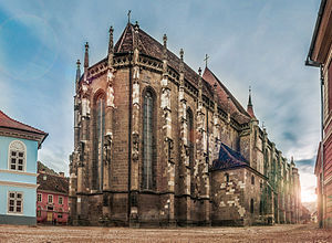
Biserica Neagră
Cathedral in Transylvania, Romania
Distance: Approx. 1638 meters
Latitude and longitude: 45.64101,25.58803
The Black Church (Romanian: Biserica Neagră, German: Die Schwarze Kirche, Hungarian: Fekete templom), stands in the city of Brașov in south-eastern Transylvania, Romania. It was built by the local Transylvanian Saxon (German) community of the city during medieval times and represents the main Gothic-style monument in the country, as well as being the largest and one of the most important houses of worship in the region which belong to the Lutheran, i.e., Evangelical Church of Augustan Confession in Romania. Author Judit Petki contends that, contrary to a widely held view, the Black Church received its dark appearance not as a result of the fire which affected much of the city in 1689, but only in recent times due to pollution.
Valea Cetății (Brașov)
River in Brașov County, Romania
Distance: Approx. 1175 meters
Latitude and longitude: 45.642,25.617
The Valea Cetății is a small river in the city of Brașov, Romania. It is intercepted by the Canalul Timiș (Timiș Canal). Its source is in the Postăvarul Massif.

Brașov railway station
Distance: Approx. 1484 meters
Latitude and longitude: 45.66116111,25.61350556
The Brașov railway station is the main station in Brașov, Romania. The building on the current location was opened to traffic in 1962. The station's bell chimes preceding the announcements represent a few notes from Ciprian Porumbescu's operetta Crai Nou.

Battle of Brașov
Battle during the Long Turkish War
Distance: Approx. 457 meters
Latitude and longitude: 45.65,25.6
The Battle of Brașov (German: Schlacht bei Kronstadt; Hungarian: Brassói csata) was fought on July 17, 1603, between the troops of Wallachia led by Radu Șerban and the Habsburg monarchy on one side and the Transylvanian troops led by Mózes Székely on the other side. Mózes Székely was killed on the battlefield, and the Wallachian lord Radu Șerban became ruler of Transylvania until September 1603, when Giorgio Basta and the imperial commissioners took control of the country in the name of the emperor.
Ioan Meșotă National College
Distance: Approx. 613 meters
Latitude and longitude: 45.654,25.609
Ioan Meșotă National College (Romanian: Colegiul National "Dr. Ioan Meşotă") bears a prestigious name in the history of Romanian education, the name of one of the founders of the educational system in Transylvania, doctor in philosophy Ioan Meșotă, a corresponding member of the Romanian Academy. Located in the civic center of Brașov, the college is one of the oldest and most prestigious in the municipality and the county, being founded in 1869.

Sala Sporturilor Dumitru Popescu Colibași
Indoor arena located in Brașov, Romania
Distance: Approx. 1544 meters
Latitude and longitude: 45.66,25.61777778
Dumitru Popescu Colibași Sports Hall is an indoor arena located in Brașov, Romania, with a total capacity of 1,700 seats. It is primarily used by the women's handball team Corona Brașov. It also hosts cultural events, such as concerts.

Áprily Lajos National College
State school in Brașov, Romania
Distance: Approx. 1469 meters
Latitude and longitude: 45.6446,25.5879
Áprily Lajos High School (Romanian: Colegiul Național "Áprily Lajos"; Hungarian: Áprily Lajos Főgimnázium) is a Romanian state school located in Centrul Vechi, a neighborhood of Brașov, Romania. The school educates children aged between 5 (grade 0) and 19 years old (grade 12). Named after Hungarian poet Lajos Áprily, the school is the only Hungarian-language high school in Brașov.

Museum of Urban Civilization
Museum in Brașov, Romania
Distance: Approx. 1538 meters
Latitude and longitude: 45.6415,25.5891
The Museum of Urban Civilization (in Romanian: Muzeul Civilizației Urbane) is a museum in Brașov, Romania. The museum is located on the south side of the Piața Sfatului, the main historic square of the city. To the north in the centre of the square is the Brașov County Museum of History and to the southwest is the Black Church.

Saint George's Church, Brașov
Church in Brașov, Romania
Distance: Approx. 253 meters
Latitude and longitude: 45.64784,25.60291
Saint George's church (Romanian: Biserica Sfântul Gheorghe, Hungarian: Szent György-templom) is a church in Brașov. Originally it was as a residential building, and it was dedicated as an Orthodox church in 1934. It acquired its present look in the 1980s.

Brașovechi Church
Heritage site in Brașov County, Romania
Distance: Approx. 1411 meters
Latitude and longitude: 45.6544,25.5893
The Brașovechi Church, also known as "The Dormition of the Mother of God" Church (Brașovechi)" is a Romanian Orthodox church located at 47 Bisericii Române Street, Brașov, Romania. Located in the Brașovechi district, it is dedicated to the Dormition of the Theotokos. After the Patent of Toleration was issued in 1782, the Romanians of Brașov sent a number of petitions to the local and Viennese authorities, asking to build a church.
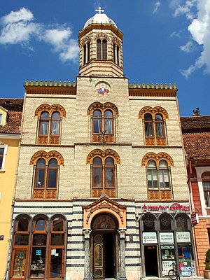
Piața Sfatului Orthodox Church
Heritage site in Braşov County, Romania
Distance: Approx. 1446 meters
Latitude and longitude: 45.64281,25.58937
The Piața Sfatului Orthodox Church is a Romanian Orthodox church located at 3 Piața Sfatului, Brașov, Romania. It is dedicated to the Dormition of the Theotokos. A small one-room chapel opened inside the Brașov Citadel in 1829.

Greek Church (Brașov)
Orthodox church in Brasov, Romania
Distance: Approx. 1645 meters
Latitude and longitude: 45.64148,25.58751
The Greek Church (Romanian: Biserica Grecilor) is a Romanian Orthodox church located at 12 Gheorghe Barițiu Street, Brașov, Romania. It is dedicated to the Holy Trinity.
Weather in this IP's area
few clouds
31 Celsius
31 Celsius
30 Celsius
32 Celsius
1017 hPa
36 %
1017 hPa
954 hPa
10000 meters
3.13 m/s
70 degree
18 %
05:38:27
21:07:05