Country:
 Netherlands
Region:
City:
Latitude and Longitude:
Time Zone:
Postal Code:
IP information under different IP Channel
ip-api
Country
Region
City
ASN
Time Zone
ISP
Blacklist
Proxy
Latitude
Longitude
Postal
Route
IPinfo
Country
Region
City
ASN
Time Zone
ISP
Blacklist
Proxy
Latitude
Longitude
Postal
Route
MaxMind
Country
Region
City
ASN
Time Zone
ISP
Blacklist
Proxy
Latitude
Longitude
Postal
Route
Luminati
Country
NLASN
Time Zone
Europe/Amsterdam
ISP
Stichting Internet Domeinregistratie Nederland
Latitude
Longitude
Postal
db-ip
Country
Region
City
ASN
Time Zone
ISP
Blacklist
Proxy
Latitude
Longitude
Postal
Route
ipdata
Country
Region
City
ASN
Time Zone
ISP
Blacklist
Proxy
Latitude
Longitude
Postal
Route
Popular places and events near this IP address
Arnhem
City and municipality in Gelderland, Netherlands
Distance: Approx. 532 meters
Latitude and longitude: 51.98333333,5.91666667
Arnhem (Dutch: [ˈɑrnɛm] or [ˈɑr(ə)nɦɛm] ; German: Arnheim [ˈaʁnˌhaɪ̯m] ; Ernems: Èrnem) is a city and municipality situated in the eastern part of the Netherlands, near the German border. It is the capital of the province of Gelderland, located on both banks of the rivers Nederrijn and Sint-Jansbeek, which was the source of the city's development. Arnhem is home to the Hogeschool van Arnhem en Nijmegen, ArtEZ Institute of the Arts, Netherlands Open Air Museum, Airborne Museum 'Hartenstein', Royal Burgers' Zoo, NOC*NSF and National Sports Centre Papendal.
Battle of Arnhem
Failed British airborne operation in Arnhem, Netherlands. Part of Operation Market Garden
Distance: Approx. 743 meters
Latitude and longitude: 51.98027778,5.90027778
The Battle of Arnhem was fought during the Second World War,as part of the Allied Operation Market Garden. It took place around the Dutch city of Arnhem and vicinity from 17 to 26 September 1944. The Allies had swept through France and Belgium in August 1944, after the Battle of Normandy.

Yssel-Supérieur
Department of the First French Empire
Distance: Approx. 530 meters
Latitude and longitude: 51.9833,5.91667
Yssel-Supérieur (French: [i.sɛl.sy.pe.ʁjœʁ]; "Upper IJssel"; Dutch: Boven IJssel) was a department of the First French Empire in the present-day Netherlands. It was named after the river IJssel. It was formed in 1810 (1810), when the Kingdom of Holland was annexed by France.

Liberation of Arnhem
WWII expulsion of military of Nazi Germany from Arnhem, Netherlands
Distance: Approx. 500 meters
Latitude and longitude: 51.98444444,5.91
Operation Anger (sometimes known as Operation Quick Anger) was a military operation to seize the city of Arnhem in April 1945, during the closing stages of the Second World War. It is also known as the Second Battle of Arnhem or the Liberation of Arnhem. The operation was part of the Canadian First Army's liberation of the Netherlands and was led by the 49th British Infantry Division, supported by armour of the 5th Canadian Armoured Division, Royal Air Force air strikes and boats of the Royal Navy.

St Eusebius' Church, Arnhem
Distance: Approx. 127 meters
Latitude and longitude: 51.979,5.9102
St. Eusebius church also known as the Eusebiuskerk or the Grote Kerk, at 93 metres is the largest church, and the largest building in Arnhem, The Netherlands. Notably the building contains an elevator that was added to the church in 1994, which allows visitors to travel to the top of the spire and view the city of Arnhem from its highest point.

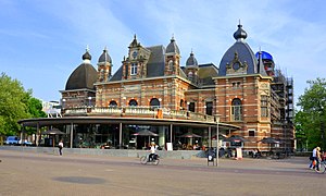
Arnhem Centraal railway station
Railway station in Arnhem, Netherlands
Distance: Approx. 879 meters
Latitude and longitude: 51.98472222,5.90083333
Arnhem Centraal railway station is the largest railway station in the city of Arnhem in Gelderland, Netherlands. It was opened on 14 May 1845 and is located on the Amsterdam–Arnhem railway, the Arnhem–Leeuwarden railway and the Arnhem–Nijmegen railway. The station opened at the same time as the Amsterdam–Arnhem railway, that continues into Germany via the Oberhausen–Arnhem railway.

Arnhem Velperpoort railway station
Railway station located in Arnhem, Netherlands
Distance: Approx. 826 meters
Latitude and longitude: 51.985,5.92
Arnhem Velperpoort is a railway station located in Arnhem, Netherlands. The station was opened on 1 October 1893, closed on 3 June 1918 and reopened on 5 January 1953. It is located on the Arnhem–Leeuwarden railway and the Oberhausen–Arnhem railway.
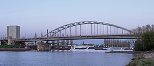
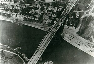
John Frost Bridge
Bridge over the Lower Rhine at Arnhem
Distance: Approx. 590 meters
Latitude and longitude: 51.97472222,5.91194444
John Frost Bridge (John Frostbrug in Dutch) is the road bridge over the Lower Rhine at Arnhem, in the Netherlands. The bridge was inaugurated after the end of World War II, and is named after Major-General John Dutton Frost (1912–1993), who commanded the British forces that reached and temporarily defended the pre-existing Rijnbrug ("Rhine Bridge") at the same location during the Battle of Arnhem in September 1944. This was the bridge referenced in the 1977 Anglo-American film A Bridge Too Far, although the IJssel bridge in Deventer was used for the actual shooting of the film.

Rijnhal
Indoor arena in Arnhem, Netherlands
Distance: Approx. 1978 meters
Latitude and longitude: 51.96333333,5.90111111
Rijnhal is a 5,000-capacity indoor arena located in Arnhem, Netherlands. The arena opened in 1972 and is primarily used for sports and concerts. Past notable artists that have performed at Rijnhal include AC/DC, Bon Jovi, Alice Cooper, Scorpions and Aerosmith.

Museum Arnhem
Distance: Approx. 1421 meters
Latitude and longitude: 51.98527778,5.89222222
Museum Arnhem (formerly known as Gemeentemuseum Arnhem and then Museum voor Moderne Kunst Arnhem) is a museum of modern art, contemporary art, applied art and design in Arnhem, Netherlands, with art from the 20th century. The museum reopened its doors on 13 May 2022 after a major renovation that lasted more than four years. Previous directors have included Liesbeth Brandt Corstius.

Battle of Arnhem (1813)
1813 battle during the War of the Sixth Coalition
Distance: Approx. 532 meters
Latitude and longitude: 51.98333333,5.91666667
The Battle of Arnhem (30 November 1813) saw Friedrich Wilhelm Freiherr von Bülow's Prussian corps fight an Imperial French division under Henri François Marie Charpentier at Arnhem. Attacking under the cover of fog, the Prussians broke into the city at several points and forced the French to retreat to Nijmegen after hard fighting in this War of the Sixth Coalition clash. Arnhem is a city in the Netherlands located on the Rhine River 100 kilometres (62 mi) southeast of Amsterdam.
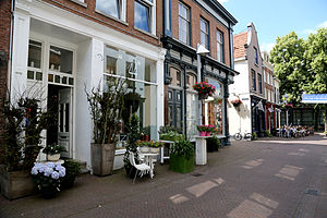
De 7 straatjes
Neighbourhood in Arnhem, Netherlands
Distance: Approx. 202 meters
Latitude and longitude: 51.98091667,5.90855556
De 7straatjes (Dutch for "the 7 little streets") is a neighbourhood in the historical centre of Arnhem, in the Netherlands. The alternative name is the Stegenkwartier. The neighbourhood is famous for its small cafes, wine bars, restaurants and the diverse design and art shops.
Weather in this IP's area
broken clouds
15 Celsius
15 Celsius
15 Celsius
17 Celsius
1018 hPa
89 %
1018 hPa
1016 hPa
10000 meters
2.24 m/s
280 degree
75 %
05:52:34
21:32:54