Country:
 Romania
Region:
City:
Latitude and Longitude:
Time Zone:
Postal Code:
IP information under different IP Channel
ip-api
Country
Region
City
ASN
Time Zone
ISP
Blacklist
Proxy
Latitude
Longitude
Postal
Route
IPinfo
Country
Region
City
ASN
Time Zone
ISP
Blacklist
Proxy
Latitude
Longitude
Postal
Route
MaxMind
Country
Region
City
ASN
Time Zone
ISP
Blacklist
Proxy
Latitude
Longitude
Postal
Route
Luminati
Country
RORegion
bv
City
racos
ASN
Time Zone
Europe/Bucharest
ISP
Attifiber Srl
Latitude
Longitude
Postal
db-ip
Country
Region
City
ASN
Time Zone
ISP
Blacklist
Proxy
Latitude
Longitude
Postal
Route
ipdata
Country
Region
City
ASN
Time Zone
ISP
Blacklist
Proxy
Latitude
Longitude
Postal
Route
Popular places and events near this IP address
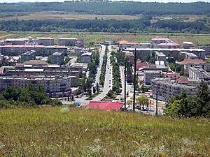
Motru
Municipality in Gorj, Romania
Distance: Approx. 91 meters
Latitude and longitude: 44.80361111,22.97083333
Motru (Romanian pronunciation: [ˈmotru]) is a city in Romania, Gorj County. It is situated on the river Motru and its tributary, the river Ploștina, in western Oltenia. The county capital Târgu Jiu is located about 35 km (22 mi) northeast.
Ploștina (river)
River in Gorj County, Romania
Distance: Approx. 1963 meters
Latitude and longitude: 44.7863,22.9785
The Ploștina is a left tributary of the river Motru in Romania. It discharges into the Motru in the town Motru. Its length is 13 km (8.1 mi) and its basin size is 26 km2 (10 sq mi).
Lupoaia (Motru)
River in Gorj County, Romania
Distance: Approx. 1805 meters
Latitude and longitude: 44.8022,22.9491
The Lupoaia is a left tributary of the river Motru in Romania. It flows into the Motru near the village Lupoaia. Its length is 10 km (6.2 mi) and its basin size is 16 km2 (6.2 sq mi).
Coșuștea Mică
River in Mehedinți County, Romania
Distance: Approx. 9854 meters
Latitude and longitude: 44.7492,22.8732
The Coșuștea Mică is a right tributary of the river Coșuștea in Romania. It flows into the Coșuștea in Ciovârnășani. Its length is 25 km (16 mi) and its basin size is 64 km2 (25 sq mi).
Peșteana (Motru)
Tributary of the river Motru in Romania
Distance: Approx. 6179 meters
Latitude and longitude: 44.7524,23.0031
The Peșteana is a right tributary of the river Motru in Romania. It flows into the Motru near Broșteni. Its length is 22 km (14 mi) and its basin size is 85 km2 (33 sq mi).
Crainici
River in Mehedinți County, Romania
Distance: Approx. 7450 meters
Latitude and longitude: 44.844,22.897
The Crainici is a right tributary of the river Motru in Romania. It discharges into the Motru in Dealu Viilor. Its length is 19 km (12 mi) and its basin size is 198 km2 (76 sq mi).

Cătunele
Commune in Gorj, Romania
Distance: Approx. 3390 meters
Latitude and longitude: 44.81666667,22.93333333
Cătunele is a commune in Gorj County, Oltenia, Romania. It is composed of six villages: Cătunele, Dealu Viilor, Lupoaia, Steic, Valea Mănăstirii and Valea Perilor.
Samarinești
Commune in Gorj, Romania
Distance: Approx. 8561 meters
Latitude and longitude: 44.75,23.05
Samarinești is a commune in Gorj County, Oltenia, Romania. It is composed of nine villages: Băzăvani, Boca, Duculești, Larga, Samarinești, Țirioi, Valea Bisericii, Valea Mică, Valea Poienii.

Broșteni, Mehedinți
Commune in Mehedinți, Romania
Distance: Approx. 4177 meters
Latitude and longitude: 44.76666667,22.98333333
Broșteni is a commune located in Mehedinți County, Oltenia, Romania. It is composed of six villages: Broșteni, Căpățânești, Luncșoara, Lupșa de Jos, Lupșa de Sus and Meriș.

Florești, Mehedinți
Commune in Mehedinți, Romania
Distance: Approx. 4091 meters
Latitude and longitude: 44.77,22.95
Florești is a commune located in Mehedinți County, Oltenia, Romania. It is composed of nine villages: Copăcioasa, Florești, Gârdoaia, Livezi, Moșneni, Peșteana, Peștenuța, Stroești and Zegujani.
Amutria
Distance: Approx. 5721 meters
Latitude and longitude: 44.83,22.91
Amutria (Amutrion, Amutrium, Admutrium, Ad Mutrium, Ad Mutriam, Ancient Greek: Ἀμούτριον) was a Dacian town close to the Danube and included in the Roman road network, after the conquest of Dacia. The name is homonymous with the ancient name of the nearby Motru River. Its possible position at this river's junction gives a certain importance.
Weather in this IP's area
clear sky
21 Celsius
21 Celsius
21 Celsius
21 Celsius
1016 hPa
54 %
1016 hPa
995 hPa
10000 meters
1.41 m/s
1.39 m/s
318 degree
06:10:49
20:58:08