Country:
 Romania
Region:
City:
Latitude and Longitude:
Time Zone:
Postal Code:
IP information under different IP Channel
ip-api
Country
IPinfo
Country
MaxMind
Country
Luminati
Country
RORegion
gr
City
crevediamare
ASN
Time Zone
Europe/Bucharest
ISP
Orange Romania S.A.
Latitude
Longitude
Postal
db-ip
Country
ipdata
Country
Popular places and events near this IP address
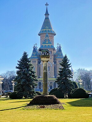
Timișoara Orthodox Cathedral
Distance: Approx. 268 meters
Latitude and longitude: 45.75055556,21.22416667
The Orthodox Cathedral (Romanian: Catedrala Ortodoxă), also known as the Metropolitan Cathedral (Romanian: Catedrala Mitropolitană), is a Romanian Orthodox church in Timișoara. The cathedral is the seat of the Archbishopric of Timișoara and the Metropolis of Banat. It is dedicated to the Three Holy Hierarchs, Basil the Great, Gregory the Theologian and John Chrysostom.

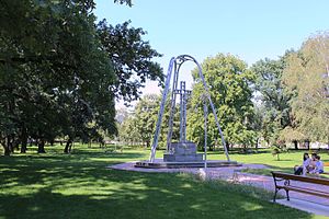
Roses Park, Timișoara
Distance: Approx. 375 meters
Latitude and longitude: 45.75,21.23194444
Roses Park (Romanian: Parcul Rozelor), previously known as Rosarium or Ștefan Plavăț Park of Culture and Leisure, is an urban park in Timișoara, located north of the Bega River.
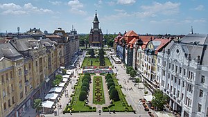
Victory Square, Timișoara
Square in Timișoara, Romania
Distance: Approx. 377 meters
Latitude and longitude: 45.75246667,21.22513056
The Victory Square (Romanian: Piața Victoriei), known until 1990 as the Opera Square (Romanian: Piața Operei), is the central square of Timișoara. It is the place where Timișoara was proclaimed on 20 December 1989 the first city free of communism in Romania. It was a main boulevard, transformed into a square after the closure of the southern side by the construction of the Metropolitan Cathedral.
Justice Park, Timișoara
Distance: Approx. 20 meters
Latitude and longitude: 45.74944444,21.22694444
The Justice Park (Romanian: Parcul Justiției), previously known as the People's Council Park, is an urban park in central Timișoara.

Alpinet Park
Distance: Approx. 355 meters
Latitude and longitude: 45.74861111,21.22277778
Alpinet Park (Romanian: Parcul Alpinet), also known in the past as the Arboretum, is an urban park along the Bega River in Timișoara. Alpinet Park is one of the young parks of the city, being arranged in the 20th century.

Cathedral Park, Timișoara
Distance: Approx. 308 meters
Latitude and longitude: 45.75,21.22333333
The Cathedral Park (Romanian: Parcul Catedralei) is an urban park in Timișoara. It is located behind the Metropolitan Cathedral, across the Anton Scudier Central Park and covers an area of 45,400 m2.

Capitoline Wolf, Timișoara
Heritage site in Timiș County, Romania
Distance: Approx. 358 meters
Latitude and longitude: 45.75222222,21.225
Capitoline Wolf is a statue located in Timișoara's Victory Square, between the Metropolitan Cathedral and the Palace of Culture. Copy of the famous Capitoline Wolf, the statue was donated by the municipality of Rome in 1926 as a symbol of Latinity that unites the Romanian and Italian peoples. The statue depicts the legend of the founders of Rome, the brothers Romulus and Remus, suckled by a she-wolf.

Central Library of Politehnica University of Timișoara
Library in Timișoara, Romania
Distance: Approx. 295 meters
Latitude and longitude: 45.74694444,21.22861111
The Central Library of Politehnica University is the library of the Politehnica University of Timișoara. Between 1947 and 2014 it functioned in the Piarist High School ensemble.

Israelite High School (Timișoara)
Jewish school in Romania
Distance: Approx. 196 meters
Latitude and longitude: 45.75111111,21.22777778
The Israelite High School was a school of the Jewish community of Timișoara. The high school operated between 1919 and 1948, with a number of about 700 students. It had four middle school classes for girls, eight theoretical high school classes for boys and eight commercial high school classes for boys.

Dauerbach Palace
Building in Victory Square, Timișoara
Distance: Approx. 406 meters
Latitude and longitude: 45.7525,21.22444444
The Dauerbach Palace (Romanian: Palatul Dauerbach), or simply Palace (from the restaurant of the same name housed on the ground floor), is a historic building in the center of Timișoara, Romania in Victory Square, built in 1913 in Art Nouveau style for Georg Dauerbach and designed by the architect László Székely. It is located in the part of the square known as Corso.

Hilt-Vogel Palace
Building in Victory Square, Timișoara
Distance: Approx. 368 meters
Latitude and longitude: 45.75194444,21.22416667
The Hilt-Vogel Palace (Romanian: Palatul Hilt-Vogel) is a historic building in Victory Square in Timișoara, Romania. It was built between 1911 and 1913, according to the plans of Hungarian architect László Székely. The building is attached to the Széchényi Palace, designed by the same architect.

Széchényi Palace
Building in Victory Square, Timișoara
Distance: Approx. 360 meters
Latitude and longitude: 45.75166667,21.22388889
The Széchényi Palace (Romanian: Palatul Széchényi) is a historical building in the center of Timișoara, Romania in Victory Square. It is the last building on the Corso, at the end towards the cathedral.
Weather in this IP's area
clear sky
28 Celsius
29 Celsius
27 Celsius
29 Celsius
1014 hPa
56 %
1014 hPa
1004 hPa
10000 meters
3.09 m/s
80 degree
05:55:36
21:24:58