Country:
 Portugal
Region:
City:
Latitude and Longitude:
Time Zone:
Postal Code:
IP information under different IP Channel
ip-api
Country
Region
City
ASN
Time Zone
ISP
Blacklist
Proxy
Latitude
Longitude
Postal
Route
IPinfo
Country
Region
City
ASN
Time Zone
ISP
Blacklist
Proxy
Latitude
Longitude
Postal
Route
MaxMind
Country
Region
City
ASN
Time Zone
ISP
Blacklist
Proxy
Latitude
Longitude
Postal
Route
Luminati
Country
PTRegion
11
City
lisbon
ASN
Time Zone
Europe/Lisbon
ISP
Servicos De Comunicacoes E Multimedia S.A.
Latitude
Longitude
Postal
db-ip
Country
Region
City
ASN
Time Zone
ISP
Blacklist
Proxy
Latitude
Longitude
Postal
Route
ipdata
Country
Region
City
ASN
Time Zone
ISP
Blacklist
Proxy
Latitude
Longitude
Postal
Route
Popular places and events near this IP address

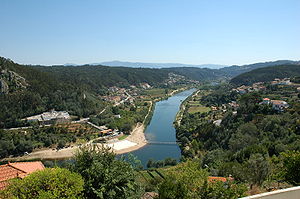
Mondego River
River in northern Portugal
Distance: Approx. 7431 meters
Latitude and longitude: 40.21316944,-8.34479167
The Rio Mondego (European Portuguese: [ˈʁi.u mõˈdeɣu]) or Mondego River is the longest river entirely within Portuguese territory. It has its source in Serra da Estrela, the highest mountain range in mainland Portugal (i.e. excluding the Portuguese islands).
Penacova
Municipality in Centro, Portugal
Distance: Approx. 7059 meters
Latitude and longitude: 40.27055556,-8.28333333
Penacova (Portuguese pronunciation: [pɨnɐˈkɔvɐ] or [ˌpen-]) is a town and a municipality in the Coimbra District, in Portugal. The population in 2011 was 15,251, in an area of 216.73 km2.
Vila Nova de Poiares
Municipality in Centro, Portugal
Distance: Approx. 59 meters
Latitude and longitude: 40.21083333,-8.2575
Vila Nova de Poiares (Portuguese pronunciation: [ˈvilɐ ˈnɔvɐ ðɨ poˈjaɾɨʃ] ) is a municipality in the Coimbra district, in Portugal. The population in 2011 was 7,281, in an area of 84.45 km².
Arrifana (Vila Nova de Poiares)
Civil parish in Centro, Portugal
Distance: Approx. 2980 meters
Latitude and longitude: 40.232,-8.278
Arrifana (Portuguese pronunciation: [ɐʁiˈfɐnɐ]) is a civil parish in the municipality of Vila Nova de Poiares, Portugal. The population in 2011 was 1,440, in an area of 23.84 km².
Vila Nova do Ceira
Civil parish in Centro, Portugal
Distance: Approx. 9782 meters
Latitude and longitude: 40.181,-8.149
Vila Nova do Ceira is a Portuguese parish in the municipality of Góis. The population in 2011 was 929, in an area of 19.70 km².

Alva River
River in northern Portugal
Distance: Approx. 9570 meters
Latitude and longitude: 40.29583333,-8.24611111
Alva River (Portuguese: Rio Alva, Portuguese pronunciation: [ˈalvɐ]) is a river in Portugal. It flows into the Mondego River. The river Alva is a mountain river, a tributary of the Mondego, rising on the southwest slope of the Serra da Estrela and running about 110 kilometres (68 mi) until draining into the river Mondego, which occurs in the town of Porto de Raiva, parish of Oliveira do Mondego, Municipality of Penacova In the District of Coimbra after the Mondego is interrupted by the Aguieira Dam.
Friúmes e Paradela
Civil parish in Centro, Portugal
Distance: Approx. 7798 meters
Latitude and longitude: 40.272,-8.214
Friúmes e Paradela is a civil parish in the municipality of Penacova, Portugal. It was formed in 2013 by the merger of the former parishes Friúmes and Paradela. The population in 2011 was 870, in an area of 22.18 km².
Lorvão
Civil parish in Centro, Portugal
Distance: Approx. 7523 meters
Latitude and longitude: 40.261,-8.316
Lorvão is a parish in Penacova Municipality, Portugal. The population in 2011 was 3,898, in an area of 26.95 km². Within the Parish of Lorvão are the following places and towns: Foz do Caneiro, Caneiro, São Mamede, Aveleira, Roxo, Paradela do Lorvão, Chelo, Rebordosa.
Penacova (parish)
Civil parish in Centro, Portugal
Distance: Approx. 7072 meters
Latitude and longitude: 40.271,-8.282
Penacova is a parish in Penacova Municipality, Portugal. The population in 2011 was 3,254, in an area of 32.42 km2.
Coiço
Distance: Approx. 10005 meters
Latitude and longitude: 40.3,-8.25
Coiço is situated in Penacova, Baixo Mondego, Centre Portugal. Coiço is integrated in the council of Penacova.
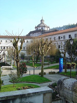
Lorvão Abbey
Distance: Approx. 7462 meters
Latitude and longitude: 40.25924,-8.31747
The Abbey of Our Lady of Lorvão (Portuguese: Mosteiro de Santa Maria de Lorvão), known simply as Lorvão Abbey, was a monastery in the civil parish of Lorvão in the Coimbra District of Portugal. According to tradition, it was founded in the 6th century, but no documentation of the foundation exists until the late 9th century, the period of the Christian Reconquest of the lands, which had then been held by Muslim conquerors for over 150 years. It served a monastic community for a thousand years.
Weather in this IP's area
few clouds
27 Celsius
27 Celsius
25 Celsius
27 Celsius
1022 hPa
34 %
1022 hPa
1005 hPa
10000 meters
0.94 m/s
1.66 m/s
287 degree
13 %
07:27:34
19:18:47